By flying over atmospheric rivers, scientists aim to improve forecasts

These drenching storms are pummeling the U.S. West Coast, bringing dangerous flooding and snow

A flooded street with stormy skies overhead

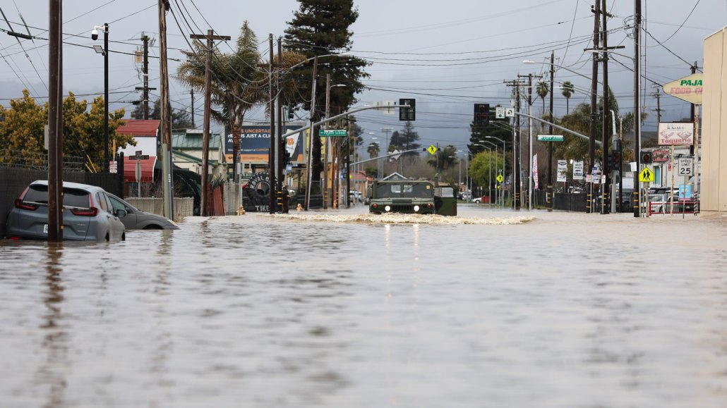
Floodwaters fill the streets of Pajaro, Calif., on March 14 in the wake of an atmospheric river that dumped heavy rain and breached a levee on the Pajaro River.

Justin Sullivan/Getty Images

The term “atmospheric river” may sound airy and ethereal, but these massive, fast-moving, drenching storms can hit as hard as a freight train. Since December, the U.S. West has been slammed with back-to-back-to-back atmospheric rivers, the most recent one deluging the state March 15 and another forecast to hit the state in the coming week. These powerful streams of water vapor arrive with strong winds, heavy rains and thick snow, spawning flooding, landslides and avalanches.

Big as they are, these storms are surprisingly tough to see coming. A week’s warning is about the best forecasters can do now.

A team of scientists is trying to change that. In just the past few months, they’ve flown more than three dozen reconnaissance missions into the storms. They’ve launched dozens of weather balloons high into the stratosphere, each carrying instruments to measure temperature, moisture, air pressure and wind. And the scientists have crunched reams of data and run hundreds of computer simulations, all to forecast when the next atmospheric river is going to arrive and how intense it’s likely to be.

The goal of this effort, the team says, is to improve predictions, to give the people in the storms’ path more time to prepare for flooding, and ultimately to find ways to manage the water for the region’s drier months.

It’s a big task, particularly during this year’s seemingly relentless barrage of storms. “We have been hammered here: December, January, February, March,” says meteorologist Marty Ralph. “It has been a long and active season.”

In just December and January, nine atmospheric rivers hammered western United States and Canada relentlessly, dumping record rain and snow across the region. Over 121 billion metric tons of water fell on California alone, according to the U.S. National Environmental Satellite Data and Information Service.

And this task is likely to become even more challenging, given lingering uncertainty over how atmospheric rivers will shift in intensity and frequency as the planet continues to warm.

Rivers in the sky

Atmospheric rivers are long, narrow bands of condensed water vapor, typically around 1,500 kilometers long and 500 kilometers across (SN: 2/11/11). The streams form over warm ocean waters, often in the tropics, and snake through the sky, transporting huge amounts of water. One atmospheric river, on average, can transport up to 15 times the volume of water at the mouth of the Mississippi River. When these storms arrive over land, they can release that water as rain or snow.

While atmospheric rivers can bring welcome water to a parched region, they also are “the primary, almost the exclusive” cause of floods on the U.S. West Coast, says Ralph.

In 2013, he and colleagues created the Center for Western Weather and Water Extremes, or CW3E, at the Scripps Institution of Oceanography in La Jolla, Calif. The group then created the first weather model tailored to predicting atmospheric rivers on the U.S. West Coast. This year, the team also created an atmospheric river intensity scale, ranking the events based on size and how much water they’re carrying.

To improve their forecasts of landfall and intensity, the team collects data from drifting ocean buoys, weather balloons and airplanes. The group even enlisted the aid of the U.S. Air Force’s hurricane hunters — most famous for flying into the eyes of tropical cyclones from June to November — to do aerial reconnaissance (SN: 5/18/12).

The data collected by the planes fill an important information gap, says Anna Wilson. She’s a Scripps atmospheric scientist who also manages field research for CW3E. Weather balloons are the workhorses of weather prediction, but they’re launched over land, and “it’s important to see what happens before [an atmospheric river] makes landfall,” Wilson says.

Satellites can provide valuable atmospheric data over the ocean, but they generally can’t see through clouds and heavy precipitation, both characteristic features of atmospheric rivers. And atmospheric rivers hang low in the troposphere, the lowest part of Earth’s atmosphere, making it even harder for satellites to spy on them.

During each flight mission, the planes drop instruments called dropsondes that collect temperature, moisture, wind and other data as they fall. Since November 1, the hunters have flown 39 missions into the atmospheric rivers, Wilson says.

In the U.S. West, atmospheric rivers tend to arrive from January through March. But that’s not really the start of atmospheric river season in this region: Atmospheric rivers make landfall in the Pacific Northwest earlier in the year, in the late fall. One such storm devastated that region in November 2021, spawning a deadly series of floods and landslides.

“That storm not only hurt people, it hurt the economy,” Ralph says, causing “thousand-year flooding that destroyed rail lines right in the middle of a serious supply chain issue.”

In the aftermath of that event, CW3E and their partners received funding to begin the airplane reconnaissance flights on November 1, two months earlier than these missions have begun in the past.

How will climate change affect atmospheric rivers?

Aside from the data-gathering challenges in predicting these storms, it’s also hard to disentangle the many factors that feed into them, from warm tropical waters to large-scale weather patterns such as the El Niño Southern Oscillation. How a warming world will influence on these storms is uncertain too, Ralph says.

“One thing to keep in mind is that the fuel of an atmospheric river is water vapor. It’s pushed along by the wind, formed by the temperature gradient between the poles and the equator,” he says.

Atmospheric rivers are also often associated with extratropical cyclones, mid-latitude storms formed by the collision of cold and warm water masses. Such cyclones can interact with an atmospheric river, perhaps pulling it along. One such fast-forming “bomb cyclone” helped spur on an atmospheric river that drenched California in January.

A map illustrating an atmospheric river swirling around dry air off the west coast of the U.S. The 'river' runs from the Pacific Ocean up to around Oregon then abruptly down toward Mexico.
A water vapor-laden atmospheric river (dark blue-green) swirls around drier (brown) air as it streams toward the U.S. West Coast on January 4. The storm brought high winds and heavy rain, and caused flooding and downed power lines. Bluer colors indicate more water vapor per area of the atmosphere.Lauren Dauphin/NASA Earth ObservatoryA water vapor-laden atmospheric river (dark blue-green) swirls around drier (brown) air as it streams toward the U.S. West Coast on January 4. The storm brought high winds and heavy rain, and caused flooding and downed power lines. Bluer colors indicate more water vapor per area of the atmosphere.Lauren Dauphin/NASA Earth Observatory

Global warming may be having two possibly offsetting effects on atmospheric rivers: Warmer air can hold more water vapor, which means more fuel for the storms. But the poles are also warming faster than the equatorial regions, which reduces the temperature difference between the regions, and that can weaken the winds.

“But what we’re finding is that even with that reduced gradient, there are still times when cyclones can form,” Ralph says. And those storms are feeding off the increase in water vapor. That, he says, could mean bigger and longer-lasting atmospheric rivers in the future.

Some studies suggest climate change won’t necessarily increase the number of atmospheric rivers, but it might increase their variability, Wilson says. “We may have more frequent shifts between very, very, very wet seasons and very, very, very dry seasons.” A warmer climate in general can mean that water is sucked up out of the soil more quickly.

That seesaw scenario is likely to make water management even more of a challenge in the U.S. West, where atmospheric rivers are already both a blessing and a curse. Still, “we’re very hopeful,” Wilson says, that the data will ultimately aid in the region’s complicated water management, such as by giving planners enough time to safely let water out of reservoirs before they’re flooded.

The events also provide as much as half of the region’s annual precipitation, bringing much-needed water to parched lands and topping off the snowpack in the high mountains, another reservoir of freshwater. This year’s storms “have done a lot to restore the landscape drought,” Ralph says, “greening up” the landscape and refilling many smaller reservoirs.

But “drought is a complicated thing,” Ralph says (SN: 4/16/20). The historically low water levels in larger reservoirs in the West, such as Lake Powell and Lake Mead, isn’t so quickly replaced. “It will take more wet years like this one to recover.”

Carolyn Gramling is the earth & climate writer. She has bachelor’s degrees in geology and European history and a Ph.D. in marine geochemistry from MIT and the Woods Hole Oceanographic Institution.

More Stories from Science News on Climate

From the Nature Index

Paid Content