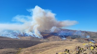
When Hurricane Ike struck the Gulf Coast in the early hours of September 13, 2008, Texas’ Bolivar Peninsula was ground zero. Before the category 2 storm made landfall, large stretches of beachfront on this narrow, low-lying spit of land were chockablock with homes standing on stilts behind dunes up to 2 meters tall.
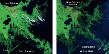
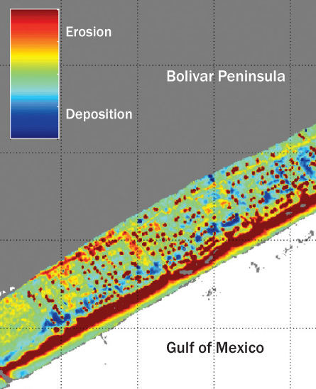
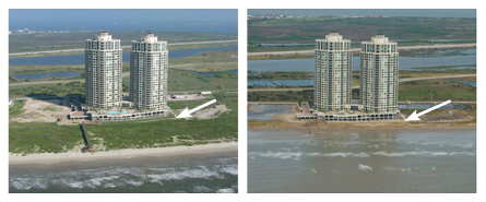
But those stilts — and the dunes — were too short: Most of the homes that didn’t get blown away by Ike’s 175-kilometer-per-hour winds were battered by waves and then swept off pilings by a 5-meter-deep, debris-filled storm surge. Terrain was swept clean, and dunes were decapitated. Across some stretches of shore, the ocean chewed inland more than 50 meters, while other sections of beach actually gained ground as storm water draining from marshes and bays carried sediment toward the sea, dropping the material at the water’s edge.
Such resculpting of shorelines by storms has become a popular research topic lately, thanks to the availability of high-tech data collection equipment ranging from sonar-equipped ships to GPS-carrying all-terrain vehicles and small aircraft with laser altimeters. As few as a dozen years ago, field studies assessing storm-induced shoreline changes required an army of surveyors and hordes of graduate students, says Asbury “Abby” Sallenger, head of the U.S. Geological Survey’s storm impacts research group in St. Petersburg, Fla.
Today, a single flight can collect high-resolution elevation data for a 300-meter-wide swath of coast stretching as far as from New York City to Boston. “It’s just no comparison,” Sallenger says. “I don’t care how many grad students are out there; you could never reproduce that.”
With these new, broader surveys, scientists are seeing better than ever how much land storms chisel from the edges of continents — not just in populated areas, where homes and infrastructure are damaged or demolished, but in the kinds of remote areas that previously went unsurveyed after storms. Along with improving damage estimates right after a major storm strike, researchers hope to do a better job of predicting future shoreline locations and assessing prospects for shore recovery after a storm.
The degree of earthmoving these studies are finding is impressive. A major storm can essentially pick up and relocate entire barrier islands, such as those that help protect Atlantic and Gulf coasts. Yet the analytical models that coastal planners use to estimate where coasts will lie in the future rely mainly on gradual, persistent rates of erosion in the past, not the effects of occasional large storms. Those transient effects have, until recently, been hard to estimate, since any given location is rarely hit by a big storm.
Backwash
The churning of sediments beneath a storm has always been hard to see. But by using shipboard sonar to map the underwater landscape, scientists got an in-depth view of massive movements of seafloor material by Hurricane Ike.
Beneath a storm’s winds, rushing water can reshape the underwater landscape, especially when a storm surge blasts onto land and then recedes across barrier islands or through narrow inlets. Besides dramatically rearranging features in navigated areas such as shipping lanes, storms leave clues in the sediments that can help scientists interpret ancient sediments long since turned to stone.
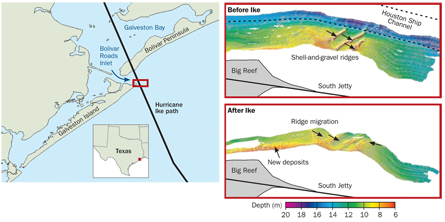
When Ike’s eye reached the eastern end of Galveston Island, just southwest of Bolivar Peninsula, hurricane-force winds — those measuring 119 km/hr or greater — covered a 180-kilometer-long stretch of coast. West of the eye, winds blew away from land and water was pushed offshore. But east of the eye, water surged inland across the Bolivar Peninsula and piled up in Galveston Bay to heights up to 5 meters.
As the storm passed and winds abated, that water returned to sea, says John A. Goff, a marine geologist at the University of Texas at Austin. As water levels in the bay dropped, flow was channeled through the inlet separating Bolivar Peninsula and Galveston Island. Buoys marking the shipping channel through the inlet, the main route leading to and from the port of Houston, were swept seaward as much as 13 kilometers — quite a feat considering the buoys’ anchors weighed more than 5 metric tons each.
By comparing sonar data gathered in the inlet a week and a half after Ike made landfall with data gathered just four months earlier, Goff and his colleagues could readily assess the storm’s erosive effects. Before the hurricane, several broad, 3-meter-tall ridges of shells and loose gravel, sculpted by the normal flow of tides in and out of the inlet, stretched across the inlet’s floor, the researchers reported in the April Geology. Those ridges had been stable for decades, Goff says.
Flow rushing through the inlet after the storm pushed the ridges seaward 40 to 50 meters and scoured away as much as two-thirds of the ridges’ height. Data gathered in May 2010, more than a year and a half after the hurricane, show that the shells and gravel are again being pushed into heaps, but those nascent ridges are accumulating where the post-Ike remnants were dropped, not where the ridges stood before the storm.
Finer material, such as sand and silt, was probably carried even farther out to sea, Goff notes. By analyzing sediment samples taken from the seafloor at varying distances from the Bolivar Peninsula, the researchers were able to estimate the amount of material stripped from shore.
The team estimates that fresh deposits of sand and mud stretched up to 15 kilometers offshore. Goff says that the piles include about 300,000 cubic meters — or about 37,500 large dump truck loads — of sand from each kilometer of coastline. And because previous studies of the seafloor in this area have suggested that material at water depths greater than 5 meters typically stays put under normal conditions, much of that sand probably won’t be coming back to shore.
But scientists are still learning how to predict shoreline recovery. John B. Anderson, a marine geologist at Rice University in Houston, isn’t so sure all that sand from Galveston Bay is lost. Because the researchers didn’t determine the size distribution of grains in the sand layer, it’s impossible to tell what proportion of those grains might be small enough to be bumped back to shore by normal wave action, even from waters up to 10 meters deep, he adds.
After looking at historical data, Goff and his colleagues contend that the sand is indeed gone for good. An extensive layer of sand dragged offshore by Hurricane Carla, which struck the Texas coast in 1961, stayed where the storm dropped it for at least a quarter of a century, they note.
Sometimes those layers of storm-shifted sand are buried by quickly accumulating sediment and thus preserved, leaving in the geological record a layer known as a “tempestite,” Goff says. Studying and understanding the modern-day processes that generate such layers can aid researchers trying to interpret the geological record. The presence of a tempestite would indicate that an area was susceptible to major storms, for example, and the size and frequency of such layers within rock formations could yield clues about ancient climates.
Diving deeper
Because hurricanes strike any given stretch of coast rather infrequently, data on the storms’ effects are hard to come by. On the broader scale, satellite observations give scientists a look at the speed and direction of currents that hurricanes generate at the ocean’s surface, says oceanographer William J. Teague of the Naval Research Laboratory at NASA’s Stennis Space Center in Mississippi. “But once you get below the surface, there’s a void of data,” he notes.
While buoys far off the Texas coast were blown or dragged southwest as far as 35 kilometers during Ike, researchers don’t know how strong the storm-induced currents were, when the buoys moved or what path they took — it’s clear only where the buoys ended up. But new analyses of data collected by seafloor instruments during another hurricane, 2004’s Ivan, could let researchers make some reasonable guesses about water’s scouring power beneath the surface.
Just before Ivan slammed into the Gulf Coast, it passed directly over an array of seafloor sensors deployed in mid-depth waters on the continental shelf south of Mobile, Ala. At that time, Ivan was a category 4 hurricane creeping northward at about 20 km/hr, Teague says. Previously, his team’s analysis of data gathered during the event revealed the largest waves ever measured by instruments (SN: 6/11/05, p. 382). Now, the group’s work gives an unprecedented look at the effects of huge waves at depths normally undisturbed by events at the ocean’s surface. “These data make it possible to study the physics underneath a hurricane,” Teague says.
In normal conditions, currents crawl along the ocean bottom at about 1 millimeter per second. But as Hurricane Ivan passed over, seafloor currents rushed about a thousand times faster, Teague and colleagues report in the June 16 Geophysical Research Letters. And while steady currents are the norm for deep water, the researchers estimate that shear stresses induced in seafloor sediments by the waves were about four times higher than those triggered by everyday currents.
The strong back-and-forth action of Ivan’s waves was particularly effective at stirring up sediment; upward-looking sonar detected sediment suspended in the water as much as 25 meters above the ocean floor.
The researchers did have one surprise, says Teague: Currents set in motion by the hurricane were strong enough to shuffle sediment across the ocean floor for nearly a week after the storm had passed. During that week, currents scoured more than 30 centimeters of material from beneath one of the sensors, he notes.
Results of this study will not only help scientists improve and calibrate models of subsurface currents, says Teague, but they’ll also help engineers make seafloor pipelines more resilient in storms. This is no small problem: According to a report released by the Minerals Management Service in February, at least 17 pipelines that crisscross the Gulf seafloor were damaged by wind- or wave-induced currents during hurricanes Gustav and Ike in 2008.
Vulnerability varies
Scientists’ next question is how much erosion will result from the powerful movement of water during a major storm in any given location. Though two stretches of coast may appear similar, their erosion rates can differ substantially. Along the Atlantic Coast, the shore erodes inland, on average, between 60 centimeters and a meter each year; annual rates of erosion along the Gulf Coast are double that (SN: 7/8/00, p. 20).
And while all Gulf shores are at risk of being struck by major storms, some areas are more vulnerable to erosion than others. In southern Louisiana, and particularly in the Mississippi Delta, long-term sinking, or subsidence — a phenomenon resulting from reduced deliveries of river sediment and the ongoing withdrawal of oil and gas from underground reservoirs — makes barrier islands unusually susceptible to storms. Rising sea levels only aggravate the problem.
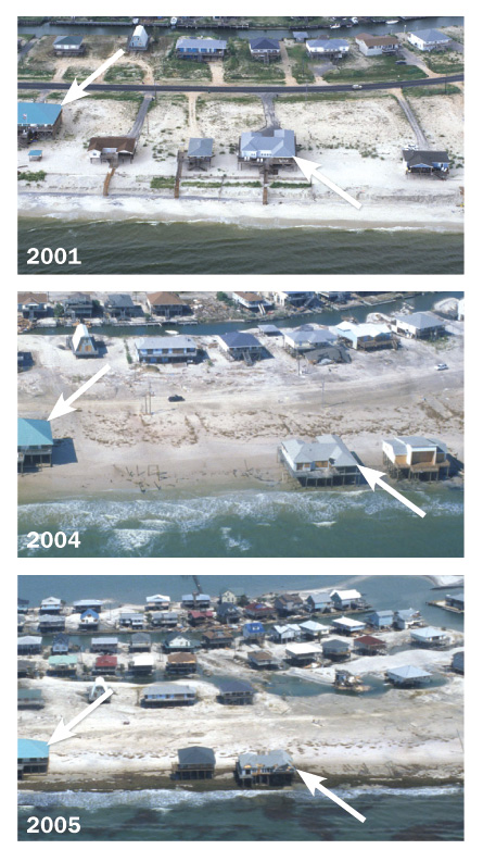
Even along relatively stable shores such as Texas’ Gulf Coast, long-term rates of erosion can differ dramatically from one swath of land to the next, says Rice’s Anderson. Analyses of aerial photos suggest that Galveston Island and the Bolivar Peninsula each lost an average of 1.3 to 1.4 meters of beach each year between the 1930s and the 1980s, Anderson’s team notes in the June 8 Eos. The shore of Matagorda Island, southwest of Galveston Island, actually beefed up by about a meter a year over the same period, thanks to the convergence of sediment-laden currents there.
But long-term average rates of erosion don’t tell the full story, says geophysicist Neil Frazer of the University of Hawaii at Manoa. His team’s studies indicate that models that include only the average rates and ignore the temporary effects of storms don’t do a good job of estimating what portions of the coastline are safe for development. That’s been true in his research on Assateague Island along the Maryland and Virginia coast between 1995 and 2003, and in studies along the Delaware coast, where data have been collected since the 1920s.
With coastal populations growing at the fastest rates in the country, better estimates of future erosion are becoming more important than ever.
“If I were a shoreline manager, I could take long-term data and make a best bet about where the shoreline would possibly be in 2040,” Frazer says. “But then I could consider the effects of a single major storm and argue that maybe I’d better not plan on the shoreline being there exactly, because that storm could come along and blow you away…. Things can look the same for 50 years, then ‘Bang!’ ” he notes.
That happened on the Bolivar Peninsula with Hurricane Ike, where erosion averages 1.3 meters per year, but Ike sluiced away at least 30 times that in one fell swoop. Using predictions of erosion based on average rates but also including the temporary impacts of a major storm might have made prudent developers think twice about building structures on the low-lying land — or at least let the developers know that their buildings needed taller stilts.