Firefighters are constantly trying to predict what a fire will do next, and a wrong guess can lead to death. Now, a group of mathematicians and scientists is working to provide a new tool for making more accurate predictions.
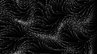
The new model is based on a fundamental and longstanding observation that the Santa Ana winds powering the recent conflagration in Southern California emphasize: weather is a crucial driver of wildfire. But wildfire also creates its own weather. It sucks air from the surroundings, which results in winds that fan the flames.
The researchers realized that the only way to predict with reasonable accuracy what a fire is going to do is to build a model that combines fire and weather patterns. Firefighters already use programs that calculate expected fire speed on the basis of the slope of the terrain and the type of vegetation covering it, along with air temperature and wind speed, but such predictions serve only as the roughest of guides.
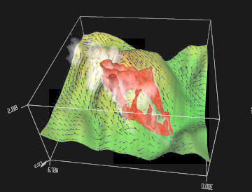
In 2002, the Big Elk Fire burned more than 4,000 acres in Colorado. This still image is taken from a computer simulation of the fire. The arrows show the direction of the wind near the ground. To see videos of the full simulation, click on the image above, or go to http://www.vets.ucar.edu/vg/FIRE/bigelk.shtml. |
The challenge is formidable. “Fire is very unpredictable,” says Jan Mandel, the principal investigator for the project and a mathematician at the University of Colorado at Denver. “It can go this way; it can go that way; that’s just the nature of the beast.” The best the researchers can hope to do is to figure out probabilities that will help guide firefighters, showing not just the most likely scenarios but also others that are less likely but still possible.
To improve their model’s predictive powers, the experts are creating ways to update the model every half-hour with the latest fire and weather information. That requires developing new methods to gather such data on the spot—quickly.
One of the team’s methods is to have planes fly above the fire with thermal and infrared sensors that can see through the smoke and clouds to find hot spots within the fire. Mandel and his colleagues are building software that can automatically process data from the sensors.
The team is also developing small, autonomous fire detectors that can be dropped into the area from airplanes or carried in by firefighters. The detectors would be equipped with radio transmitters, GPS, and a variety of sensors for measuring factors such as smoke, carbon monoxide, temperature, or humidity. The team is designing the devices so that a fire can burn right over them without causing any damage. Once the flames pass, the sensor would resume sending data.
The aerial and ground sensors would send their data to a supercomputer at a remote location. The supercomputer would then use this information, along with continually updated weather information, to calculate in what direction the fire is likely to spread and how quickly. It would send the results to handheld computers that firefighters would carry with them in the field.
The project has a $2 million dollar budget from the National Science Foundation and involves a team of ten researchers, including mathematicians, computer scientists, fire scientists, and meteorologists. In addition to designing the model itself, the scientists are designing the autonomous sensors, figuring out how to process data from the infrared sensors, and working out the details of how to communicate reliably with firefighters in remote locations.
The logistical challenges are formidable. Supercomputing resources would need to be accessible as soon as a fire breaks out. Data about terrain and vegetation would need to be available for all fire-prone areas, in formats that the modeling software can use at a moment’s notice.
The team has now completed its initial version of the model and is starting to test it on historical fire data. One of the fires chosen is the Esperanza, Calif. fire of 2006, which killed five firefighters who were defending a house. The fire moved so fast that the firefighters didn’t have time to reach shelter in their nearby fire engine. Janice Coen, a meteorologist at the National Center for Atmospheric Research in Boulder, Colo. and one of the model’s developers, says that the model is helping to show why that fire became so intense so suddenly.
Coen is hesitant to claim that the model will save firefighters’ lives because “there’s not ever one mistake, there are many mistakes that come together to create a fatality.” But if the model helps to prevent a mistake or two, that might be enough to tip the balance. And it certainly may help set firefighters’ minds at ease to have a little guidance as they guess what the fire will do next.
If you would like to comment on this article, please see the blog version.