Global gale warning

Strong winds increase on world’s oceans

As salty sea captains can attest, winds and waves can appear out of nowhere on the open sea.

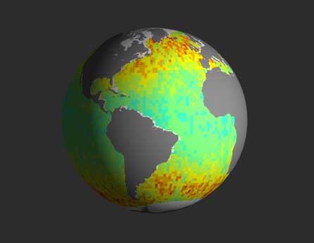
EXTREME WAVES The world’s biggest waves and fastest winds may be getting even bigger and faster, a new analysis of roughly two decades of satellite data suggests. Changes in wave heights between 1985 and 2008 (largest increases shown in red), for example, reveal that waves at higher latitudes seemed to peak more than equatorial waves. ©Science/AAAS

Now, an analysis of satellite readings suggests that winds may be picking up speed over oceans worldwide. The seven seas aren’t getting gustier on the whole, but severe winds are getting stronger, researchers from Swinburne University of Technology in Melbourne, Australia report online March 24 in Science. That’s bad news for sea captains, perhaps, but good news for surfers, since waves may also be getting higher, the team says.

The windy trend isn’t necessarily surprising, says Peter Challenor, who tracks ocean conditions in the North Atlantic. Global climate change could theoretically make oceans windier or wavier, but weather often goes through natural cycles too, says Challenor, a researcher at the National Oceanography Centre, Southampton in England. Wind speeds in the North Atlantic, for instance, vary based on multidecade shifts in the atmospheric pressures over Spain and Iceland. What’s surprising here is that the Australian researchers appear to have detected changes on a worldwide scale.

“We always assumed that each region was separate,” Challenor says. “They’ve shown that everywhere seems to be going up, which suggests that there may be a global pattern.”

The group analyzed 23 years of wave-height recordings and 17 years of wind data from seven different satellites. The fastest 1 percent of winds spiked the most over the period studied. These gales sped up in most locales by about 0.75 percent or more per year.

Waves didn’t surge as much, although at high latitudes the biggest swells got about half a percent bigger per year. That mismatch isn’t too shocking, says study coauthor Ian Young, a physical oceanographer and engineer now at the Australian National University in Canberra. A storm in one corner of the world can often make waves in another, he says. “A lot of the ocean wave conditions are swells which generate somewhere completely different.”

Wave heights are relatively easy to record from space with radar, but wind speeds are a bit trickier, Young says. Winds don’t just make waves, they also change water texture — blow softly into your morning cup of coffee and you’ll see tiny ripples appear. Those ripples scatter radar pulses coming from satellites, making for a fuzzier picture of the ocean. With a bit of math, fuzzy can be translated into windy.

“The sheer volume of trends is impressive,” says Philip Callahan, an engineer at NASA’s Jet Propulsion Laboratory in Pasadena, Calif. He’d like to see data from other satellites with different recording tools to confirm the observations. And it’s too early to say if the faster wind speeds are a true trend or just the uphill portion of a natural cycle, like an El Ni±o event but on the global scale.
Regardless, if winds keep on surging and waves climbing, sea captains the world over could be in for rough sailing, Challenor says. Looking at the trends on the computer is one thing, seeing them from a boat, another: “If you’re a mariner, they are very practical things.”

More Stories from Science News on Earth