A glacier burst, flooding Juneau. Again. This one broke records
Flooding from meltwater is getting worse in Alaska’s capital. Here’s what’s causing it

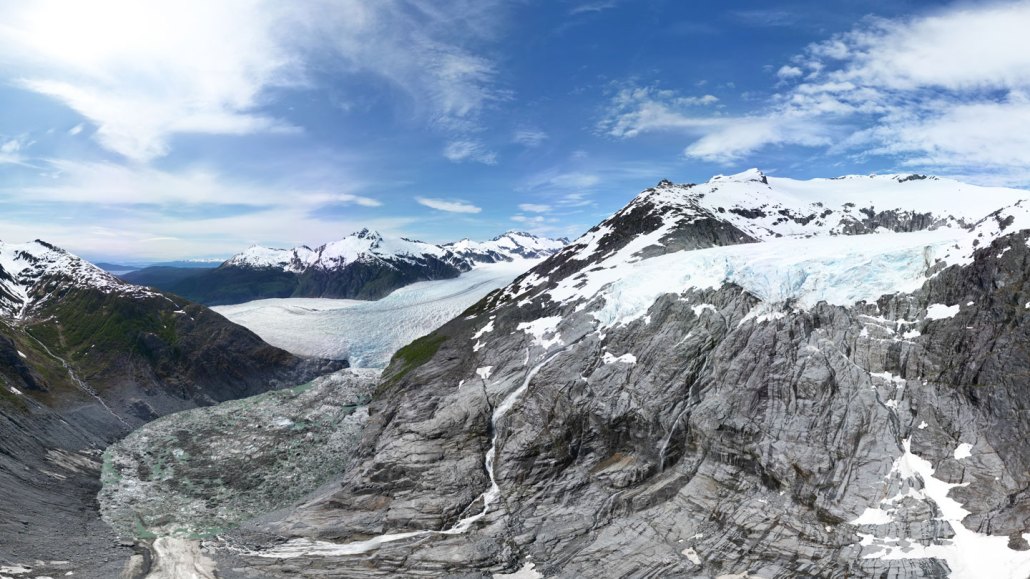
A few decades ago, a tributary glacier fed into Mendenhall Glacier (visible at the valley bottom). Warming caused it to retreat, leaving behind a barren rock bowl that fills with rain and meltwater each summer. That water escapes beneath the glacier, unleashing a flood of up to 60 million cubic meters toward Juneau, Alaska.
Diego Norena/University of Alaska Southeast
By Douglas Fox
A glacial outburst has sent floodwaters rushing through the town of Juneau, Alaska, forcing residents to evacuate parts of the state capital. The unusual event, called a glacial lake outburst flood, or GLOF, happened as water spilled out of an ice-dammed lake and gushed downstream through melted tunnels in the underside of a large glacier.
The people of Juneau have experienced at least one such flood every summer for the last 15 years.
“It’s a story about glacier change,” says Jason Amundson, a glaciologist at the University of Alaska Southeast in Juneau, who is monitoring the event. The warming climate has caused glaciers here to shrink and separate from one another. That’s left an empty valley along the edge of Mendenhall Glacier, which now fills with rain and meltwater each summer. At some point, the water collects deep enough that its pressure forces an opening under the edge of the glacier — allowing it to escape.
The amount of water that escapes is increasing, Amundson says. CThe last couple of years, we’ve had much bigger floods.”
Authorities are considering construction projects that might one day divert these floods, but Juneau residents are already taking matters into their own hands — building levees of earth and rock up to four meters high around their houses.
GLOFs have long been known to occur from time to time in places like Alaska, Iceland, the Alps, the Andes and the Himalayas. They usually happen far from human populations. In fact, prior to just over a decade ago, they didn’t happen in Juneau.
But something strange happened in July 2011. Water levels in the Mendenhall River, which meanders through town, suddenly rose on a clear, rainless day for no obvious reason.
Local scientists took a helicopter to search for the source of the flood — and eight kilometers from town, they found it: A bare mountain basin larger than 100 football fields, that was hemmed in by Mendenhall Glacier on its lower end. This ice-dammed basin filled with rain and meltwater during summer — creating the perfect conditions for a GLOF, says Eran Hood, a glacial hydrologist also at the University of Alaska Southeast who was on that helicopter flight.
“It was a mystery that should have been predicted ahead of time,” he says, because people knew the ice-dammed lake was there. As he peered down through the window, he realized that something new had happened: The lake had lost much its water. It had probably spurted out under the glacier.
A team including Hood and Amundson now conduct periodic drone surveys to measure the lake as it grows during summer. The U.S. Geological Survey monitors the lake using remote-operated cameras and a laser range finder that measures the changing water height. They used this information, plus several local river flow gauges, to create an online dashboard that provides updates on forecasts, water levels and flood maps.
The floods have happened every summer since. But they didn’t grow much until 2023 and 2024, when the water volume suddenly doubled compared with previous years, reaching 60 million cubic meters — equal to about 24,000 Olympic-sized swimming pools. Those two episodes flooded hundreds of houses and eroded riverbanks — leaving some houses protruding dangerously over the rushing water.
Although these outburst floods are linked to warming and glacier retreat, GLOFs can also occur in other circumstances, Amundson says. If a glacier advances quickly, it can block off a side valley, creating a new place where water can accumulate in an ice-dammed lake.
This year’s flood in Juneau began early on August 12. The river, which is normally more of a creek, rose by two meters overnight, peaking by 7:15 a.m. local time at a record flow of nearly 1,400 cubic meters per second — greater than the average flow of the Arkansas River.
Ahead of this year’s flood, the town prepared more than ever. In addition to the permanent levees that some people built around their homes, authorities installed temporary barriers along the river, which mostly held through the flood’s crest, protecting many houses.
The U.S. Army Corps of Engineers is considering broader solutions that would take years to enact — such as a new dam or even a hole drilled through the mountains to drain the water before it bursts out under the glacier.
But for now, Amundson, Hood and colleagues have a more immediate goal. On the afternoon of August 13, they planned to board a helicopter, which will take them to a ridge over the lake, where they will camp. Once the lake has fully drained, they’ll take photos and measurements of the exposed bowl, to map its size and depth, in hopes of better estimating how much it can hold — and how large a flood it might release in future years.
That will help people plan ahead — whether it’s the Army Corps of Engineers, or local residents building dikes around their homes. “It’s crazy,” Hood says. It looks like people “live in a castle with a wall around it.”
“This is the new normal if this is where you live.”