Dust up north

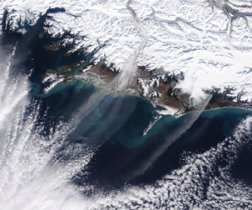
Strong northeasterly winds blowing across coastal regions of southern Alaska launched massive clouds of dust over the Gulf of Alaska in mid-March. Most of the material in these plumes is known as rock flour, a fine-grained sediment that glaciers create in prodigious quantities as they grind their way to the sea.

MIGHTY WIND. A large stream of dust, near the center of this satellite image, wafts from Alaska’s Copper River delta, located about 200 kilometers east of Anchorage. A thinner plume to the east stems from silt deposited at the foot of the Bering Glacier. J. Descloitres/NASA GSFC

Early melting of snow this year exposed the silty areas, according to NASA. The agency released an image of dust clouds taken by the Terra satellite on March 13. Wind gusts in the area reached nearly 160 kilometers per hour, and stiffer gusts of about 175 km/hour at Anchorage International Airport shut down the facility for about 9 hours on the day the image was captured.

****************

If you have a comment on this article that you would like considered for publication in Science News, send it to editors@sciencenews.org. Please include your name and location.

More Stories from Science News on Earth