Ice spy

A new way for satellites to spot small bergs

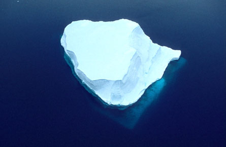
Radar altimeters on Earth-orbiting probes can detect and count small icebergs even under cloudy skies, providing warning to ships and invaluable data for scientists monitoring climate change.

UNDER THE RADAR Space-based radar altimeters can spot and track icebergs as small as 1 kilometer across, even under cloudy skies, a new analysis suggests. R. Ricker, NOAA/NOS/ORR

Large icebergs that cast off from Antarctica on a regular basis, some the size of small European countries, are slow-moving and therefore easy to track (SN: 5/12/01, p. 298). Their smaller kin, however — including kilometer-sized chunks that break off the larger behemoths as they melt — threaten ships just as much as the large bergs, says Jean Tournadre, an oceanographer at the French Research Institute for Exploitation of the Sea in Plouzané. Those smaller bits of ice, besides being harder to spot from space, are often masked by consistently cloudy conditions, he notes.

Enter the radar altimeter. Such instruments have been monitoring sea level, among other phenomena, for the last 13 years. Previous studies indicated that tall, highly reflective objects like ships showed up in the radar data, so Tournadre and his colleagues scrutinized the data gathered around Antarctica to see if they could spot icebergs. Indeed they could, the researchers report in an upcoming Journal of Geophysical Research (Oceans). In data gathered from December 2004 through November 2005, they detected more than 8,000 bergs in the open waters around the icy continent.

Most of the icebergs that the team detected were drifting near the Antarctic Peninsula, off the West Ice Shelf or in the Ross Sea — areas noted for their concentrations of icebergs, says Tournarde.

Previous research hints that as much as 50 percent of the ice that flows off Antarctica melts before it breaks away as icebergs, says Tony Payne, a glaciologist at the University of Bristol in England. Nevertheless, he notes, “It would be interesting to know where the ice is coming from and how much of it there is.”

The team’s analyses indicate that the spaceborne radar altimeters can discern icebergs that stand at least 8 meters above the ocean’s surface and measure at least 1 kilometer across, Tournadre says. Besides providing the raw material for an early warning system for ships at sea, such data could prove a boon for climate researchers, the scientists note.

Researchers have a rough idea of the volume of ice that reaches the sea when Antarctic megabergs break off ice shelves and immense ice streams, says Tournadre. However, details are lacking on how much ice is contained in bergs spawned by the continent’s smaller glaciers — a measurement that the new technique could help provide. Also, analyses of data gathered over the past 13 years could enable scientists to discern whether variations in iceberg volume around Antarctica correlate with trends in the region’s climate.


More Stories from Science News on Earth