- More than 2 years ago
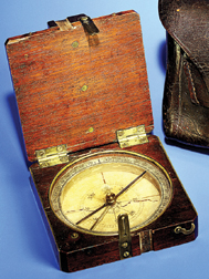
When Meriwether Lewis and William Clark set off to explore the Louisiana Territory in 1804, President Thomas Jefferson directed them to note the location of interesting points along the way. The explorers diligently calculated latitude and longitude and recorded compass bearings as they traversed the continent.


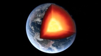
But compasses have a major drawback for creating long-lasting maps. Instead of pointing to the geographic North Pole, which is constant, they align with the magnetic north, which changes as molten iron moves within Earth’s core.
Lewis and Clark took sextant readings of the positions of the sun and North Star to be used with their compass measurements to calculate the difference between the geographic and magnetic poles. However, computation of this so-called magnetic declination was never completed.
Nearly 200 years later, geologist Robert E. Criss of Washington University in St. Louis has finished the job, and he’s used the results to fine-tune the explorers’ maps. By filling in gaps in the historical record, his findings also add to the understanding of Earth’s interior magnet.
“[Lewis and Clark] were stunningly good record keepers. They got more than enough data to make these determinations,” says Criss, who reports his findings in the October GSA Today.
Criss mined the explorers’ expedition journals for records on the altitude and compass-determined direction of the sun and North Star. He then used tables to calculate the star’s known location on given dates in the early 1800s and compared the two sets of locations to determine how far the magnetic pole was throwing the compass out of whack.
Criss found that the magnetic pole was just less than 8 east of true north in St. Louis at the start of the explorers’ journey but was around 20 east at Cape Disappointment, Wash., where the explorers turned around to head for home. The current declination in St. Louis is 0, and in Washington State, it’s still around 20 east.
Whereas ships’ captains have recorded declinations over the oceans for the past 400 years, the U.S. interior was a blank until the second half of the 19th century. The new measurement provides the earliest midcontinent data.
Scientists are still working out how Earth’s core creates the planet’s magnetic field. “We need to understand as well as we can the time and space changes in Earth’s magnetic field in order to figure out how the field operates,” says Robert F. Butler of the University of Arizona in Tucson. “Theories are only as good as the records of past variations.”
Criss also used the declinations to correct some of the explorers’ maps. For example, he looked at one sketch of Big Bend, S.D., where Lewis and Clark took compass measurements and estimated distances between campsites. Once Criss rotated the map 12.5 counterclockwise to compensate for the magnetic declination at that time, the map proved remarkably similar to current maps, he says, a tribute to the explorers’ careful observations.
“With Lewis and Clark, there’s an often-heard message of heroism,” says Criss. “There’s another message hidden here about what fine scientists they were.”
****************
If you have a comment on this article that you would like considered for publication in Science News, send it to editors@sciencenews.org. Please include your name and location.
To subscribe to Science News (print), go to https://www.kable.com/pub/scnw/
subServices.asp.
To sign up for the free weekly e-LETTER from Science News, go to http://www.sciencenews.org/subscribe_form.asp.


