Science From On High
Google Earth gives researchers new access
If Christopher Columbus wanted to travel the globe today, he wouldn’t need three ships and the financial backing of royalty — an Internet connection would do the trick. With Google Earth’s three-dimensional interactive view of the planet, Columbus could sail to the New World from the comfort of his living room (after checking out an overhead view of his house in Genoa).

By combining satellite imagery, aerial photography and geographic data, Google Earth provides views of planet Earth — and its moon and Mars — that were once available only to the well-funded and tech-savvy. And while the computer program offers unprecedented virtual trips to places many would never be able to visit, such as the Colosseum and the Galápagos Islands, Google Earth isn’t just a tool for voyeuristic global tourists. The technology is changing the way scientists conduct research.
Some are using the tool for good old scientific discovery, à la Lewis and Clark, who documented much of the wildlife of the American West. Ecologist Adelia Barber, for example, scouts the rugged and largely inaccessible terrain of California’s White Mountains seeking the long-lived bristlecone pine. Barber, of the University of California, Santa Cruz, has found that Google Earth’s resolution of that swatch of the globe is good enough for her to tell a bristlecone forest from a stand of pi±on pine, greatly simplifying her efforts to map and study bristlecones.
Marine ecologist Elizabeth Madin is taking this bird’s-eye view to the seas. After a colleague mentioned seeing halos of bare sand around sections of coral reef on Google Earth, Madin, a postdoctoral fellow at the University of Technology, Sydney, immediately suspected that small critters munching swaths of seaweed formed the rings. Madin checked out the lagoons of Australia’s Great Barrier Reef with the program and was astounded that the little nibbles of fish and sea urchins might have such a visible effect.
“These are really small-scale interactions and yet they have really large-scale effects that you can actually see from space,” Madin says. “It’s cool.”
Subsequent trips to the reef confirmed that the barren rings were what are called “grazing halos,” relatively safe zones into which the grazers dare venture from the reef’s shelter. Further looking via Google Earth revealed no such halos in a heavily fished section of a reef off Jakarta.
In areas where overfishing has cleared out top predators, small grazers dine where they like, leaving no obvious footprint, Madin and her colleagues reported online June 14 in Scientific Reports. Google Earth might be a good tool for remotely monitoring interactions between predators and prey in all kinds of environments, Madin says. She can imagine scientists probing such relationships high in the Rockies, where the reintroduction of wolves is shifting elk populations, thus altering the distribution of plants on which elk graze.
Getting to reefs often involves hiring a boat and a crew of scuba divers, which can cost tens of thousands of dollars, Madin says. Likewise, high mountain habitats can be hard to reach. But surveying from space may provide scientists like her with a “first cut,” saving time and money.
“At this stage we’re really using it like a telescope,” she says. While Google Earth surveys won’t replace on-the-ground work, they could be harnessed for conservation management, says Madin, especially in areas with limited staff and funding.
An eye on the wild
Zoologist Iain Douglas-Hamilton, founder of Kenya-based Save the Elephants, is doing just that.
Shortly after Google Earth was released in 2005, Douglas-Hamilton brought his tracking data from GPS collars on African elephants to Google and asked for help integrating the data with the program. Today, the tagged elephants’ whereabouts are streamed onto Google Earth’s satellite maps. This visual data, which the scientists can access from anywhere in the world, provides details about the when, where and why of elephant movement. Working with Google Earth has offered new insights into elephant ranges and roadways, for example, shedding light on favorite watering holes, the value of protected corridors of land and who is interacting with whom.
“It provides a really nice overview of what an elephant’s been up to,” says Jake Wall, a graduate student at the University of British Columbia in Vancouver who is working with Save the Elephants.
More recently, the team has used the program to spot potential poaching. If a young and healthy elephant stops moving or suddenly moves a very long distance — both red flags that the animal has been killed — Douglas-Hamilton’s team can send a detailed history of that elephant to local wildlife officials.
Google Earth is all about visuals, not analysis, Wall notes. He compares it to Microsoft PowerPoint, which makes data pretty and digestible, as opposed to Excel, which does the actual number crunching. Yet visual tools in the right hands can have great power, providing a universal language that crosses scientific disciplines. Public health officials recently harnessed Google Earth to guide an entire vaccination program after more than 50 people acquired polio during an outbreak in the Congo.
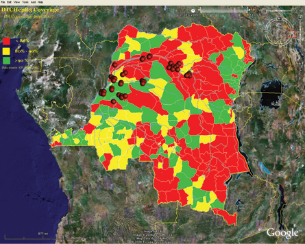
“I had my GPS device and I started putting in coordinates of reported cases,” says Raoul Kamadjeu of the U.S. Centers for Disease Control and Prevention’s global immunizations division in Atlanta. When he saw the data expressed all at once on the computer screen, Kamadjeu realized that the outbreak was tracking along the Congo River.
With Google Earth, which provided much better geographic data than available handmade maps, Kamadjeu and his colleagues could estimate how long it would take and how many staff members were needed to vaccinate every young child living along a particular stretch of the river. The program allowed the design of a speedy and effective campaign that vaccinated many people who had previously been missed, he reported in the International Journal of Health Geographics in 2009. This “river strategy” continues to be helpful in fighting polio in the region today.
Caller corrections
Back in the lab, Google Earth can help scientists out in another way — as they try to test their hypotheses. The National Oceanic and Atmospheric Administration’s National Severe Storms Laboratory in Norman, Okla., collects high-resolution radar and satellite data that are fed into algorithms used for storm warnings and forecasting. One test of these predictions is voluntary reports by citizens who call to say, “Hey, it’s hailing here,” says Valliappa Lakshmanan, of the NOAA lab and the University of Oklahoma. But in sparsely populated areas, the lab might get just one data point from a citizen caller.
Now the lab integrates prediction data with Google Earth as part of an ongoing project called the Severe Hazards Analysis and Verification Experiment, or SHAVE. Phone number data sets are overlaid on a map of a region, and University of Oklahoma students are called upon to contact people in areas where storms were predicted, gathering location-specific data on when storms started, how big the hailstones are or how much a stream is overflowing its banks.
After applying this system to flash flood predictions throughout the United States in the summer of 2008, the team found that only 133 of the 417 severe events reported to SHAVE occurred within areas designated by the traditional approach.
This find suggests that the traditional algorithms aren’t capturing the full spatial extent of flash flooding, researchers from the NOAA lab and the University of Oklahoma reported in the Journal of Hydrology in November. Now the researchers can refine their algorithms to better predict which environments are most vulnerable to flash flooding, Lakshmanan says.
For all the help that Google Earth gives to researchers at NOAA and elsewhere, scientists are helping Google Earth too, uploading a wealth of data now easily available to the public. Users can access the U.S. Geological Survey’s earthquake data to see where and how big each recorded quake rumbles, look up local ant species or follow a shark as it swims the Pacific.
Students can even explore the American West. But gone are the clunky graphics of the game Oregon Trail; the experience of today’s kids approaches the richness of Lewis and Clark’s original journey.