Ancient Maya power brokers lived in neighborhoods, not just palaces
Recent evidence suggests kings did not always run the show

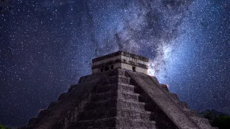
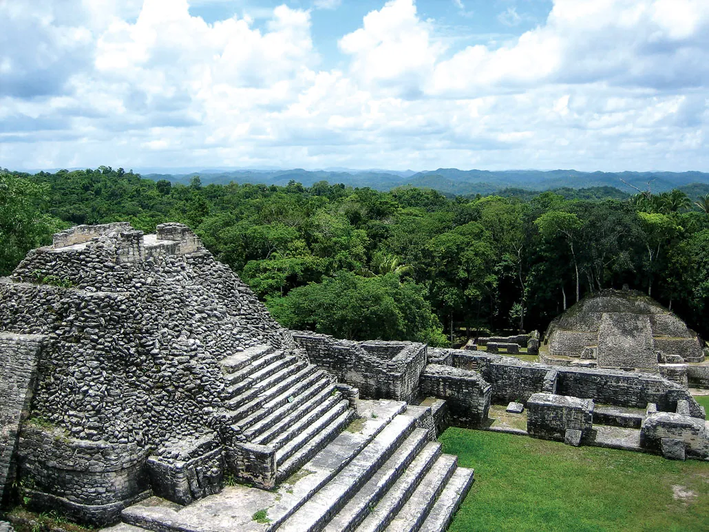
Laser technology known as lidar and recent excavations have uncovered urban sprawl around ancient Maya city centers, such as Tikal in Guatemala.
THEPALMER/E+/Getty Images Plus
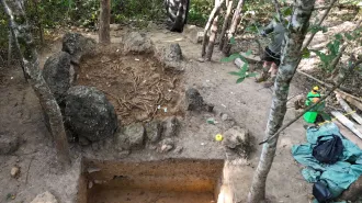
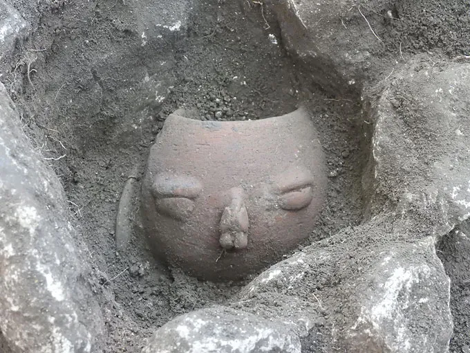
Pots with fancifully molded eyes, noses and mouths were one of the tip-offs.
Adrian Chase already had a growing sense that Maya society wasn’t quite what it’s been traditionally portrayed as: powerful rulers reigning while powerless commoners obeyed — or perhaps lived far enough from seats of power to operate largely on their own. Work by Chase and others had started to create a picture of a more politically complex society.
An archaeologist at the University of Chicago, Chase leads excavations of residential sites in and near the ancient Maya city center of Caracol in what’s now Belize. This city once sprawled across valleys, hillsides and hilltops. At its height, Caracol stretched 240 square kilometers, about the size of Milwaukee, before it was abandoned and swallowed by the forest.
Accumulating archaeological evidence had convinced Chase that shared social practices, such as placing pottery and other ritual items in special shrines, bonded groups of farm families into dozens of distinct neighborhoods within Caracol’s urban sprawl.
Consider those face-decorated pots. Varying shapes and spacings of molded eyes and other facial features added up to signature ceramic looks at different neighborhood-linked shrines. And those pots were just one element of a range of shrine offerings — including three-legged plates, curved jars with thin necks, and small medicine bottles and paint pots — that neighborhoods appeared to combine in distinctive ways.
And then there were the teeth. Individuals buried at some neighborhood shrines had either carved jade nuggets implanted in their teeth or their teeth filed in one of two styles. No such dental decorations appeared among the dead interred at other shrines. Various tooth alterations further defined neighborhood- specific shrine practices.
Pottery styles and tooth alterations together formed patterns specific to neighborhoods, Chase says. “There is a community aspect to these finds that reflects tight-knit neighborhoods.”
Caracol citizens, including those who lived well beyond downtown temples and pyramids, were not simple farmers growing crops in the service of a king, Chase suspects. Groups of as many as several hundred people had formed farming neighborhoods that built local ritual structures and followed distinctive ceremonial practices, apparently through their own collective efforts.
Neighborhoods, in turn, belonged to administrative districts with ties to royalty and other downtown political big shots. Stone compounds scattered throughout the city — each with their own ceremonial centers and plazas that probably hosted marketplaces and ritual events attended by crowds from nearby neighborhoods — represented districts’ bureaucratic service centers.
Neighborhoods and districts formed rungs of a political system in which central rulers sometimes gained power and laid down the law. At other times, royal dynasties crumbled and lower rungs in the political hierarchy assumed primary control.
Chase’s findings at Caracol have contributed to a shift in thinking about ancient Maya societies that has intensified over the last decade.
These societies, which originated as early as around 3,000 years ago, came to be known for giant stone pyramids, vast plazas and elite ballcourts discovered at jungle sites across Mesoamerica, a cultural region that extended from central Mexico to much of Central America before Spanish contact in the 1500s. These edifices had long suggested to researchers that Maya rulers wielded absolute power. So did hieroglyphics carved on stone slabs, which described kings’ exploits.
But expanded archaeological research, ongoing translations of Maya writings and the rise of airborne laser technology that sees through jungles are revealing a vast urban sprawl around major Maya ceremonial sites. Similarly extensive, low-density settlements have recently been discovered in other tropical areas around the world previously known only for giant ritual structures, such as Cambodia’s Angkor Wat temple (SN: 5/14/16, p. 22).
Among the Maya, shifting circumstances would have tilted the balance of power. For instance, rural population booms might strengthen the hand of neighborhood-level elites. Military defeats of a royal dynasty could shift power to midlevel, district officials.
“A lot of Mesoamerican settlements probably had nested units of power,” Chase says. “There was no simple division between Maya elites and commoners.”
Vaulted stone structures give insight into Maya political structures
Laura Gilabert-Sansalvador did not have Mesoamerican politics on her mind in 2013 when she began studying stone palaces at La Blanca, an ancient Maya site in Guatemala. But her project ended up providing insights into not just physical structures, but also power structures.
Working toward a doctorate in architecture, Gilabert-Sansalvador wanted to decipher ancient techniques for erecting roofs on structures ranging from huts to temples.
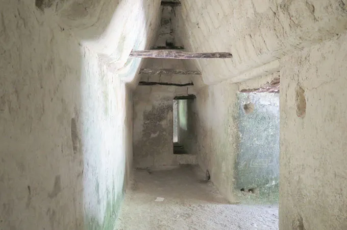
Large rooms inside La Blanca palaces featured vaulted roofs, a tricky technical feat that Maya stonemasons worked to improve for more than 1,000 years. Inspired by La Blanca’s artfully angled room toppers, Gilabert-Sansalvador launched a project to draw, digitize and analyze vaulted buildings throughout the Maya lowlands of southern Mexico and Guatemala.
Vaulted structures featured two horizontal stone walls topped by rows of stones arranged to angle inward and meet at a central row of stones, creating an inverted V- or U-shaped roof.
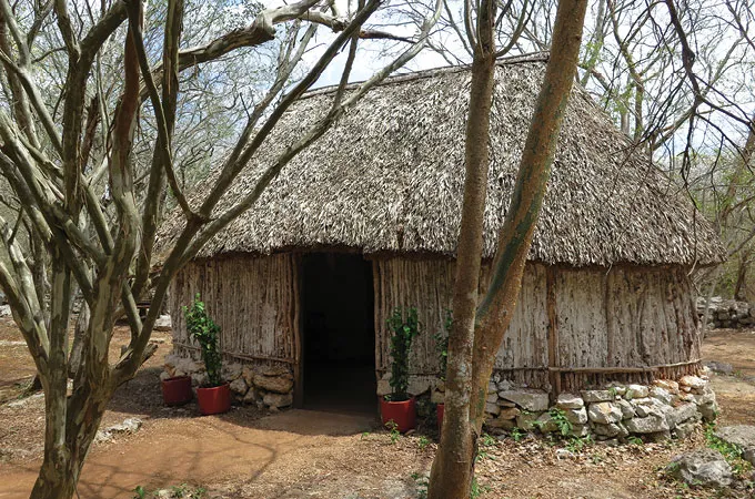
Because Maya vaults required thick, load-bearing walls, they rarely exceeded 3 meters in width. Long, narrow vaulted structures in urban centers were often connected to form rectangular, oval or L shapes around courtyards. Some sites from the Classic Maya period — which ran from about A.D. 250 to 900 and is considered by many to be the zenith of the Maya civilization — include small numbers of vaulted stone buildings. These structures were much fancier and sturdier than farmers’ huts and thus researchers suspect high-ranking officials lived there. Other Classic Maya sites contain a high percentage of vaulted structures that may have served a variety of purposes, including storing important objects, hosting feasts and housing elites.
With her doctorate and a database of measurements for the remains of 200 vaulted stone buildings in hand, Gilabert-Sansalvador arrived at Tulane University’s Middle American Research Institute in New Orleans in 2021 as a visiting researcher. There she met Tulane archaeologist Francisco Estrada-Belli, who viewed her architectural expertise as essential for solving a Maya mystery.
Estrada-Belli had spent two decades excavating small structures that had been covered in dirt over time on forest floors at several ancient Maya sites. Some structures retained only plaster floors, consistent with having been farmers’ huts made of thatch and wooden poles that had long since decayed. But others were bordered by remains of thick stone and mortar walls, raising questions about who had lived there.
In reviewing aerial images of ancient Maya buildings across southern Mexico and Guatemala, Estrada-Belli had surmised that earth-covered mounds at least 1 meter tall corresponded to the rubble of collapsed stone structures, including those with vaulted roofs, like the ones he had excavated. But he could not be sure.
Gilabert-Sansalvador’s database offered an opportunity to evaluate that suspicion with lidar, short for light detection and ranging. In archaeology, airborne lidar technology uses laser pulses to detect remains of ancient structures and objects otherwise hidden by forests and ground cover. Lidar has revealed general features of interconnected Maya cities and extensive rural drainage channels and terraces dating to at least 2,300 years ago (SN: 10/27/18, p. 11).
The challenge was to develop a geometric measure of collapsed vaulted structures that lidar could detect.
Lidar illuminates Maya neighborhoods
In 2021 and 2022, Gilabert-Sansalvador, now at the Polytechnic University of València in Spain, joined Estrada-Belli and three other researchers to review measurements in her database plus measurements of another 251 vaulted structures collected by other excavation teams. Those buildings come from throughout Maya territory, from southern Mexico and Central America to as far north as the Yucatán Peninsula.
Inspecting the entire sample of 451 structures, the researchers found that collapsed vaulted buildings had a much higher volume of rubble, formed taller mounds and had steeper sides than same-sized buildings made of perishable materials, such as thatched-roof huts.
To verify that these mound dimensions spotlight only crumpled stone structures with vaulted roofs, the team examined stone buildings previously identified in excavations and ground surveys at the Classic Maya site of Tikal in Guatemala. Overall, the researchers’ method correctly distinguished between remnants of vaulted and nonvaulted structures, such as ballcourts lined by stone walls, ceremonial buildings and inscribed stone monuments, up to 97 percent of the time.
Confident in the method, the team then analyzed 11 lidar datasets that covered Tikal and seven other Classic Maya urban centers, along with several rural territories. Lidar analyses encompassed a total of around 60,000 square kilometers, nearly the area of West Virginia. About 111,000 previously identified structures were analyzed for signs of having been built with vaulted roofs.
A picture emerged of clusters of vaulted stone buildings, typical of ruling elites’ houses in major centers. But they were in farming communities as far as five kilometers from the nearest urban core. As lidar images of rural stone compounds accumulated, Estrada-Belli felt increasingly surprised: “We checked our tests many times and concluded that this result was in fact correct.”
Small groups of huts, possibly occupied by extended families of farmers and other settlers, encircled shared plazas. Neighborhoods were made up of sets of huts clustered around stone buildings, which may have housed low-level nobles or other elites, the researchers reported in the September Journal of Archaeological Science. Sets of neighborhoods, in turn, clustered around large stone structures that may have housed higher-ranking officials, to form administrative districts.
“We now have quantitative measures of ancient Maya neighborhoods, which have been hard to define or identify,” Estrada-Belli says.
Urban sprawl managed by low- and midlevel officials flourished despite a lack of horses and wheeled vehicles, Estrada-Belli says. Transportation consisted of walking and river travel.
Raised roads, or causeways, ran from farmsteads, neighborhoods and districts to urban centers, making foot travel easier and pit stops convenient. Public plazas dotting the countryside hosted ritual gatherings and served as marketplaces. Rural elites’ duties included mediating local disputes and organizing community projects such as reservoir and causeway construction, Estrada-Belli suspects. In exchange, local officials probably collected taxes on market transactions.
Toward the end of the Classic Maya period, from around A.D. 600 to 900, local political authorities lived among many farming communities, Estrada-Belli says.
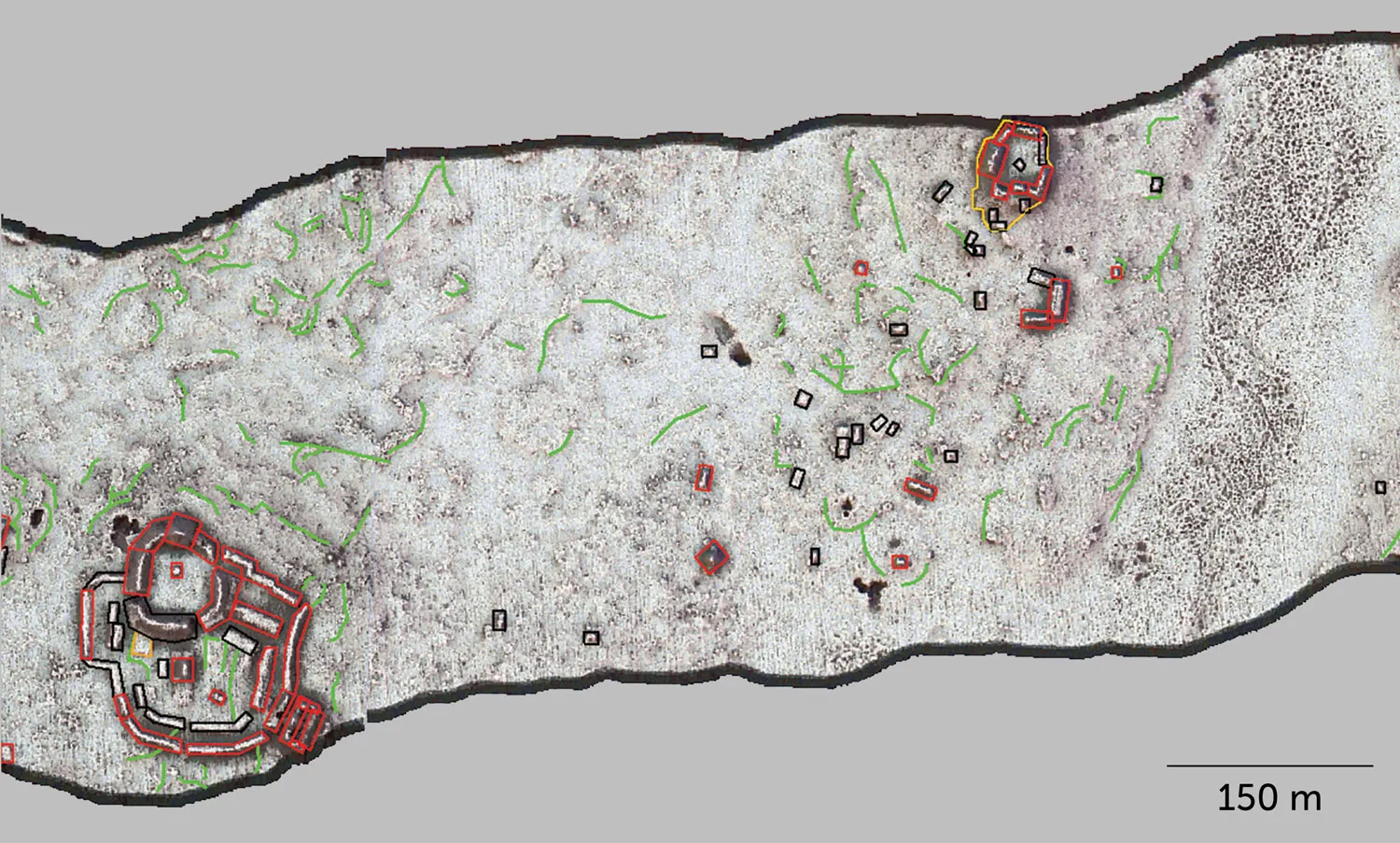
Linked in
Causeways linked many administrative centers (district nodes) within Caracol. At its peak of about 100,000 residents, estimated population densities reached over 1,000 people per square kilometer in the city center (dark red; lower densities in pink, yellow then green).

Any lingering suspicions that Maya farmers played no part in political decisions that affected their daily lives do not hold up, he contends. “We can now talk about one common model of urban organization among the Classic Maya that included the less populated countryside,” Estrada-Belli says. Maya political elites directed the construction of stone compounds at prominent locations in interconnected neighborhoods and administrative districts. This highlights the importance of central rulers in forming and running these complex political systems, he suspects.
Even among researchers impressed by the new lidar findings, though, some doubt that multilayered political systems always revolved around a king or elite political power brokers, as proposed by Estrada-Belli.
Some ancient Maya cities featured collective actions by local communities while others emphasized royal edicts, these investigators contend. And the same community could dramatically alter its political system as times and conditions changed.
Political variation across sites fits with archaeological and lidar discoveries over the last two decades that challenge a popular idea that Classic Maya cities collapsed rapidly around A.D. 900, over a span of 50 to 100 years. A group of 15 Maya researchers summarized these recent findings July 24 in the Proceedings of the National Academy of Sciences.
Residents of Maya urban centers often found ways, whether through local or centralized decision making, to survive droughts and military defeats previously thought to have been society killers, research now suggests. Major sites suffered population losses over as many as 100 to 200 years before emptying out.
At that point, Maya people who had developed a taste for social and political flexibility established towns and smaller cities elsewhere. Maya culture soldiered on after Classic period cities lost their appeal.
Why urban centers turned into ghost cities over a couple of hundred years, some more quickly than others, is poorly understood. That raises questions about precisely who lived in Estrada-Belli’s newly identified Maya stone structures and what they were up to.
Who lived in vaulted buildings?
Excavations of those stone structures, guided by the lidar findings, will help to clarify who lived there.
Some occupants of rural vaulted structures may have belonged to noble lineages that served the royal interests, says anthropological archaeologist Andrew Scherer of Brown University in Providence, R.I. Ancient DNA evidence indicates that rulers of a 2,000-year-old nomadic empire in Asia followed a similar strategy, sending members of royal lineages to oversee distant territories (SN Online: 7/2/23).
But Maya rural elites may have acquired wealth and power in local communities without being appointed by a paramount ruler, Scherer cautions. If so, it’s not clear who, if anyone, pulled the strings of neighborhood and district officials.
Advances in deciphering Maya writing and ongoing excavations indicate that midlevel authorities wielded considerable power at rural settlements aligned with urban centers such as Tikal, says anthropological archaeologist John Walden of Harvard University. Midlevel elites ran public rituals and feasts, hosted marketplaces and maintained diplomatic ties with their counterparts in nearby communities, Walden concluded in the Spring 2023 issue of The Mayanist.
It’s an open question whether some vaulted structures served as homes for heads of local kin groups or clans that prioritized their own interests over those of kings and urban big shots, Walden says.
But the new lidar findings underscore a central point, Scherer says. “Authority in some fashion was dispersed on the landscape and not clustered in Maya civic ceremonial centers.”
Reconstructing Caracol politics
At Caracol, one of the largest Classic Maya cities, authority took chameleon-like turns, Chase says. “Caracol shifted between more collective and more autocratic systems of governance over its 1,500-year life span,” he says. “The city experienced great transformations and changes as it grew.”
Chase has reconstructed Caracol’s wild historical ride using an array of evidence accumulated over the last four decades, including deciphered Maya written records carved on stone slabs, archaeological finds and lidar imagery. His conclusions appear in the 2023 Research Reports in Belizean Archaeology and in a chapter of an upcoming book that he coedited, Ancient Mesoamerican Population History. For instance, carved hieroglyphics include dates when specific rulers assumed power and won or lost battles with kings of rival cities. And lidar maps have guided ongoing excavations of farming sites outside Caracol’s city core.
Chase’s own connection to Caracol began before he could talk. His parents, anthropological archaeologists Diane Chase and Arlen Chase, both at the University of Houston, brought him there every year, starting as an infant, after launching a Caracol fieldwork project in 1985.
As a high school junior steeped in archaeology, Chase helped run a Caracol excavation. Now he oversees multiple excavations and on-site lab investigations of unearthed artifacts.
Caracol started out small too. Around 600 B.C., three villages collectively built reservoirs, causeways and ceremonial sites. Residents of the villages formed a single site that was governed without central rulers for about 700 years. A royal dynasty assumed power in A.D. 331. Successful wars against the nearby cities of Tikal and Naranjo between 553 and 680 sparked a population boom. A minimum of 100,000 people inhabited Caracol at its peak.
Urban and rural areas coalesced into a “garden city,” Chase says. He has mapped 373 neighborhoods, each linked to a nearby public space that hosted market and ritual events. In each neighborhood, residents carved agricultural terraces out of adjacent hillsides and constructed small reservoirs. Groups of neighborhoods formed 25 districts, each containing a monumental center with reservoirs, ballcourts or other large structures that provided public services, he reported in the June Journal of Anthropological Archaeology.
Chase ended up defining neighborhoods not just by combinations of pottery offerings and dental practices, but also by distances of farmers’ huts to the nearest district plaza. Farmers who would have walked similar routes over Caracol’s rugged hills to district sites presumably forged ties on those trips, which cultivated feelings of belonging to neighborhoods with common practices, such as leaving certain types of offerings at local shrines, Chase suspects.
Naranjo’s military defeat of Caracol in 680 ushered in roughly a century of decentralized government, Chase says. “Faceless administrators” who went unnamed in Maya writings oversaw taxation and the provision of services to urban communities. Policies at that time led to widespread wealth, community-wide ritual ceremonies and relatively equal access to market products and agricultural land.
New rulers who aligned themselves with powerful Maya gods assumed power in 798. These kings instituted autocratic policies and oversaw a sharp rise in wealth disparities. Those developments may have instigated a population exodus from Caracol. By 900, the garden city had been abandoned.
Estrada-Belli suspects a system of Caracol neighborhood and district officials operated out of regularly spaced, elite residences, much like the compounds of vaulted structures his team has identified elsewhere. Plans are in the works to probe lidar data at Caracol for signs of collapsed vaulted structures in or near previously identified neighborhoods, Chase says.
Classic-era sites in the northern Maya lowlands of the Yucatán Peninsula, which generally have drawn less scientific attention than Classic Maya sites to the south, also deserve closer lidar scrutiny. Vaulted structures still stand at some of those centers, including large sites such as Chichén Itzá, Estrada-Belli says.
New excavations guided by lidar discoveries, and lidar analyses informed by the dimensions of excavated buildings, may clarify Classic Maya power structures at sites on the Yucatán Peninsula.
The layering of authority and its reach across ancient Maya urban areas is just beginning to emerge from a forested shroud.