New mapping shows just how much fishing impacts the world’s seas
Fish are harvested from more than half the area covered by oceans, and some spots are super busy
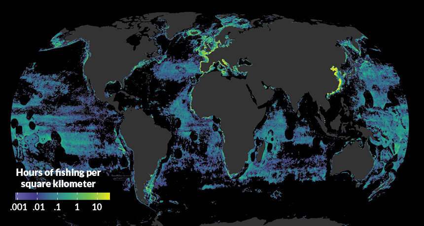
VESSEL VIEWER By tracking the activity of more than 70,000 fishing vessels, researchers made this 2016 map of total global fishing activity. Dots represent the average hours of activity within an area spanning 10,000 square kilometers.
Global Fishing Watch
Fishing has left a hefty footprint on Earth. Oceans cover more than two-thirds of the planet’s surface, and industrial fishing occurred across 55 percent of that ocean area in 2016, researchers report in the Feb. 23 Science. In comparison, only 34 percent of Earth’s land area is used for agriculture or grazing.
Previous efforts to quantify global fishing have relied on a hodgepodge of scant data culled from electronic monitoring systems on some vessels, logbooks and onboard observers. But over the last 15 years, most commercial-scale ships have been outfitted with automatic identification system (AIS) transceivers, a tracking system meant to help ships avoid collisions.
In the new study, the researchers examined 22 billion AIS positions from 2012 through 2016. Using a computer trained with a type of machine learning, the team then identified more than 70,000 fishing vessels and tracked their activity.
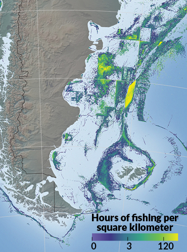
Much of the fishing was concentrated in countries’ exclusive economic zones — ocean regions within about 370 kilometers of a nation’s coastline — and in certain hot spots farther out in the open ocean, the team found. Such hot spots included the northeastern Atlantic Ocean and the nutrient-rich upwelling regions off the coasts of South America and West Africa.
Surprisingly, just five countries — China, Spain, Taiwan, Japan and South Korea — accounted for nearly 85 percent of fishing efforts on the high seas, the regions outside of any country’s exclusive economic zone.
Tracking the fishing footprint in space and time, the researchers note, can help guide marine environmental protections and international conservation efforts for fish. That may be particularly important in a time of rapid change due to rising ocean temperatures and increasing human activity on the high seas.