
The explosive eruption of Hunga-Tonga-Hunga-Ha'apai volcano in the South Pacific Ocean on January 15 spewed ash and dust into the stratosphere, while the undersea part of the event triggered a deadly tsunami.
NASA Earth Observatory
On January 15, an underwater volcano in the island nation of Tonga erupted with the explosive force of a nuclear bomb, and it may not be done just yet.
The eruption of Hunga-Tonga-Hunga-Ha’apai volcano in the South Pacific launched a towering, mushroom-shaped cloud of ash and dust at least 20 kilometers into the atmosphere — and possibly as high as 39 kilometers by one estimate. The blast sent shock waves that are still rippling through the atmosphere a week later.
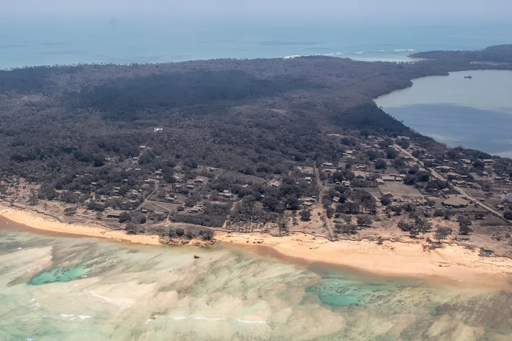
Images show ash caked on Tonga islands, coating buildings, clinging to crops and probably contaminating water supplies. The power of the explosion also triggered a rare volcanic tsunami that raced across the ocean, inundating the densely populated island of Tongatapu 65 kilometers away from the eruption, sending residents fleeing to higher ground. At least three people have died due to the eruption and tsunami.
The volcano may now return to a period of dormancy after releasing its fury. But it also might not. Researchers who have studied Hunga-Tonga-Hunga-Ha’apai’s eruptive history, recorded in layers of hardened ash and fragments of volcanic pumice, say that this volcano has tended to erupt explosively every thousand years or so — and not just once, but in multiple pulses.
Whether that will happen this time, and if so, when, is very difficult to say at this point, says Shane Cronin, a volcanologist at the University of Auckland in New Zealand. He has been working with colleagues to gather information on the volcano to help with relief efforts and predict what might come next.

“Time will tell, and the next few days may tell us a lot,” he says.
Tonga has no active seismometers — and communications from the island nation remain largely incapacitated by ashfall and flooding. But with the help of satellite images, Cronin and others are keeping close watch over the region, hunting for changes to the volcano’s shape or height or other indicators that may signal that magma might be on the move again.
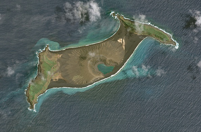
For now, the volcano’s violent past may offer some clues to its future. Even before the recent eruption, most of the volcano, including the caldera, or central crater, was submerged; now it’s sunk even farther. But at the crater’s fringe lie two small, uninhabited islands — Hunga-Tonga and Hunga-Ha’apai. They once rose a hundred meters or so above the water. That’s where, after a small 2014–2015 eruption, a new volcanic cone appeared, essentially bridging the two islands. That provided a landing spot for Cronin and his colleagues, who journeyed there in 2015 and discovered Hunga-Tonga-Hunga-Ha’apai‘s hidden history.
Cronin talked with Science News about the recent eruption, why its tsunami was so unusual and his and his colleagues’ efforts to piece together the volcano’s history. This interview has been edited for brevity and clarity.
SN: What’s happening in the eruption’s aftermath? Satellite images show a cloud of sulfur dioxide from the volcano over the Pacific.
Cronin: Yes, the plume is stretched out really long now to the northwest. It’s quite high in the atmosphere, over 25 kilometers in elevation. So it will stay there for a little while, not long enough to make a long-term climate impact but certainly enough to generate some acid rain [in the region].
SN: What are some of the ashfall hazards?
Cronin: [Satellite photos suggest many Tonga] islands are gray and covered in ash. It’s very hard to tell from the air, but it looks in the range of a few centimeters thick. That means the risk of buildings collapsing is low. The biggest problem is crops, because the ash sticks to the plants and they may die.
A secondary problem is drinking water: The ash has salts in it that dissolve in water and turn it acidic. Around 50 percent of Tongans have their water from roof-fed rainwater supplies. The taste and odor are unpleasant, and it could cause stomach upsets, but it’s not poisonous in that it doesn’t have high concentrations of heavy metals.
SN: A lot of the land you mapped in 2015 is now submerged. What’s it like to know that this place is just gone?
Cronin: It’s a bit sad. It’s remarkable how changeable these volcanic landscapes are. This one hasn’t maybe sunk in yet because I’ve been so busy in the aftermath of it. We’re still looking at all of the photos coming through of the changes. It seems that the whole top of the volcano actually just dropped vertically, by at least 10 meters; just the tips of [Hunga-Tonga and Hunga-Ha’apai] islands are now above sea level.
SN: Was there a large magma chamber under the caldera that emptied and collapsed, dropping everything down?
Cronin: That would be my interpretation. Some other volcanologists are saying there’s no evidence yet, and that the [observed volume of erupted magma] was quite small. But the explosion originated maybe 250 meters below sea level. You have material exploding upward, but also a lot that probably went sideways.
SN: When did you realize the volcano might be bigger and more explosive than suggested by the 2014-2015 eruption?
Cronin: Well, we knew that there was a bigger volcano [than just the cone] there, we just didn’t know what the shape of it was. We took with us a multibeam seafloor mapping system, thinking we’d try to map the submarine shape of the new cone.
As we were driving [offshore] with the multibeam, we started seeing a whole lot of other little submarine volcanic cones. It was like, “Wow, look at that!” And then we realized that they were all within a deep basin, about 150 meters deep. The little cones were actually all inside one large submerged caldera, about 6 kilometers across.
[Meanwhile] I spent a lot of time looking at a series of [volcanic] deposits on Hunga-Tonga and Hunga-Ha’apai. It was clear they were produced by much more violent processes [than what had formed the new cone. These deposits] were ignimbrite: They were hot, welded together and contained charcoal, which we used to get the year of the event: 1100. Then, below a layer of soil, there was another series of very similar deposits [dating to about the year 200].
SN: So basically you realized that every thousand years or so, there was a series of powerful eruptions?
Cronin: Yes. And probably there were two or three more sets of deposits underneath that array.
SN: Ocean island volcanoes like Kilauea aren’t usually very explosive (SN: 5/16/18); their basalt magma tends to be less thick and gassy. So what happened here?
Cronin: We don’t know the composition of this eruption, because we don’t have any sample material yet. But everything else we’ve sampled from this volcano is actually quite boring — it’s all basalt, more or less the same compositions during the little magma leaks as during the major explosive events.
The main difference in the major explosive events is that the magma maybe had a little bit more residence time [within the magma chamber], allowing it to accumulate more gas. [As magma rises toward the surface and the pressure decreases, gases in it expand, giving magma its potentially explosive power.]
When there’s plenty of water around and the gassy magma blasts quickly into the ocean, you can also have some explosive blasts. You’ve got the interaction of fragmenting hot magma with cold seawater, and you flash the seawater into steam, adding a lot of energy to the explosion. We call that a phreatomagmatic eruption.
SN: It’s pretty unusual for a volcano to produce a tsunami, too, isn’t it?
Cronin: Yes, there’s been a lot of discussion about how the tsunami was so energetic. It’s hard to create enough energy with volcanoes [because they don’t tend to be big enough and shift enough water to create a powerful tsunami, unlike earthquakes].
Even if you consider the whole 6-kilometer diameter of the underwater crater, and the whole thing dropping by 10 or even 100 meters, that’s still a very small area. It’s a relatively small volume of water that gets displaced to generate a tsunami.
I’ve been thinking about this the last few days, to try to explain the energy transfer from volcano to waves. During an explosive eruption, you have processes that blast material upward, producing the main eruption column. But when we are close to sea level, or maybe even submarine, you also end up generating very dense eruption columns underwater that can collapse and travel out laterally.
So you can end up with these laterally directed currents made up of a mix of hot rock particles, air and water droplets flowing down the flanks of the volcano. And we’ll never see them because they’re underneath the waves. [These flows] are potentially a mechanism for a lot more extra volume, and for a lot of lateral energy, that could create tsunami events. They’re very unusual tsunamis in that respect.
SN: The volcano had a few smaller eruptions on December 30 and January 13. Were you bracing for more?
Cronin: I was watching it like a hawk, for sure. After the 30th of December event, we scrambled around to get images to try and figure out what was happening.
The 2014–2015 eruption had some small surges at the [volcano’s] base, some jets, spectacular to look at but mainly locally important. The December 30 and January 13 events were more vertical, quite decent plumes, a step up in terms of explosive energy, and obviously the pressure was rising, and by the 15th, that pent-up, gas-rich magma was ready to erupt.
SN: So the big question: What can we expect next?
Cronin: We don’t have a lot to go on. There are no seismographs anywhere near this volcano, or in Tonga, which is a real problem. All the observations up to now were taken from a boat, or these aerial images. It’s hard to do any prediction.
So [volcanologists] have come up with three possible scenarios, small, medium and large, based on the geologic background. The large scenario is that there’s this pent-up, gas-charged magma that has erupted, and it caused a very large explosion, and has changed the shape of the upper part of the volcano. So, if new magma rapidly arrives to take its place and comes into that really unstable edifice, it may start to create further explosive eruptions, but also potential flank collapses [possibly causing more tsunamis].
The medium scenario is that there’s new magma, but [any] new cracks in the volcano’s flanks mean the magma could degas [becoming less likely to explode] before it erupts. There will still be magma-water interaction, though, and chances of a small eruption plume and maybe a small tsunami.
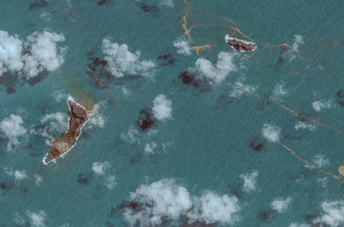
The small scenario is that there’s a little bit of residual activity, some small water-magma events, and then everything quiets down. Right now, we aren’t seeing a great deal of disturbance or discoloration in the water from aerial images, which seems to indicate that things are quieting down.
Time will tell now, and we’ll be watching.


