Satellite analysis can reveal sites of past underground nuclear tests, U.S. government scientists report. The technique can detect the settling of ground above blasts that occurred decades ago, before current monitoring networks were established.
Underground nuclear tests are restricted by the 1996 Comprehensive Nuclear Test Ban Treaty, which 170 nations have signed and 108 have ratified. The typical hallmarks of underground blasts–increases in radiation and telltale vibrations in Earth’s crust, atmosphere, or oceans (SN: 7/14/01, p. 25: Available to subscribers at The Silence of the Bams)–reveal nuclear explosions as they happen or soon after. The new radar-analysis technique, however, can identify the locations of long-ago tests, possibly revealing a nation’s unconfirmed nuclear capability. In the future, it might be used to supplement the international monitoring network of sensors.
Interferometric synthetic aperture radar (InSAR) combines data from images taken from the same point in space at two different times. Analysts can discern intervening horizontal or vertical movements of Earth’s surface as small as 1 centimeter, says Paul Vincent, a geophysicist at the Lawrence Livermore (Calif.) National Laboratory. Scientists have used the technique to detect the fall and rise of the ground’s surface as cities pump water from and into aquifers
(SN: 8/25/01, p. 119: Available to subscribers at L.A. moves, but not in the way expected) and to discover ice-bound islands (SN: 4/6/02, p. 222: Available to subscribers at Satellites discover new Arctic islands).
In their new research, Vincent and his colleagues analyzed ground movements at the Nevada Test Site, a 3,500-square-kilometer facility 100 km northwest of Las Vegas. Scientists conducted nuclear tests there between 1951 and 1992.
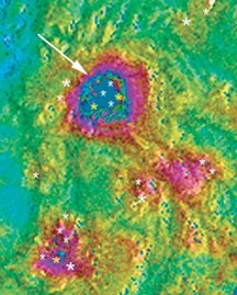
InSAR images of the facility’s Pahute Mesa site show a 2-km-long elliptical area where the ground sank about 8 cm between April 1992 and June 1993, the dates of the satellite images analyzed. That bull’s-eye marks the spot where five underground nuclear tests–including a March 1992 blast codenamed Junction–took place. The analysis detected continuing subsidence in ground over the sites of tests conducted in the late 1960s, more than 2 decades before the launch of the commercial satellite that makes today’s InSAR images, Vincent says. His team reports its findings in the Nov. 15, 2003 Geophysical Research Letters.
Subsidence at the Pahute Mesa site shows up far beyond the edges of some craters caused by blasts, says Vincent. The peripheral deformations probably come from the gradual settling of rock pulverized by the blasts. Water filtering through the ground might have dissolved some of the cracked rocks’ rough edges, permitting the ground to settle. Also, later underground blasts nearby jostled the rocks and triggered subsidence.
InSAR is a “promising technique” for finding the sites of underground nuclear tests, says William S. Leith of the U.S. Geological Survey in Reston, Va. Some test sites used by China, France, the former Soviet Union, and some other countries don’t show obvious collapse craters, he notes. However, all blasts, regardless of the terrain where they occur, probably leave some surface signs, says Leith. The trick, he adds, will be figuring out how to interpret those hallmarks.
****************
If you have a comment on this article that you would like considered for publication in Science News, send it to editors@sciencenews.org. Please include your name and location.