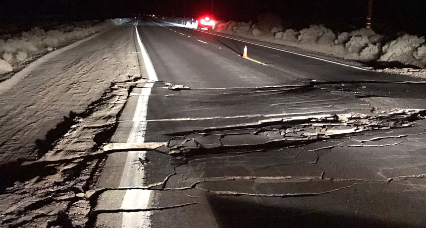
OFF ROAD A powerful magnitude 7.1 earthquake that struck July 5 along a fault in the Eastern California Shear Zone crumbled and closed part of California’s State Route 178 southwest of Trona.
USGS
A week after two large earthquakes rattled southern California, scientists are scrambling to understand the sequence of events that led to the temblors and what it might tell us about future quakes.
A magnitude 6.4 quake struck July 4 near Ridgecrest — about 194 kilometers northeast of Los Angeles — followed by a magnitude 7.1 quake in the same region on July 5. Both quakes occurred not along the famous San Andreas Fault but in a region of crisscrossing faults in the state’s high desert area, known as the Eastern California Shear Zone.
The San Andreas Fault system, which stretches nearly 1,300 kilometers, generally takes center stage when it comes to California’s earthquake activity. That’s where, as the Pacific tectonic plate and the North American tectonic plate slowly grind past each other, sections of ground can lock together for a time, slowly building up strain until they suddenly release, producing powerful quakes.
For the last few tens of millions of years, the San Andreas has been the primary origin of massive earthquakes in the region. Now overdue for a massive earthquake, based on historical precedent, many people fear it’s only a matter of time before the “Big One” strikes.
But as the July 4 and July 5 quakes — and their many aftershocks — show, the San Andreas Fault system isn’t the only source of concern. The state is riddled with faults, says geophysicist Susan Hough of the U.S. Geological Survey in Pasadena, Calif. That’s because almost all of California is part of the general boundary between the plates. The Eastern California Shear Zone alone has been the source of several large quakes in the last few decades, including the magnitude 7.1 Hector Mine quake in 1999, the magnitude 6.7 Northridge quake in 1994 and the magnitude 7.3 Landers quake in 1992 (SN Online: 8/29/18).
Here are three questions scientists are trying to answer in the wake of the most recent quakes.
Which faults ruptured, and how?
The quakes appear to have occurred along previously unmapped faults within a part of the Eastern California Shear Zone known as the Little Lake Fault Zone, a broad bunch of cracks difficult to map, Hough says. “It’s not like the San Andreas, where you can go out and put your hand on a single fault,” she says. And, she adds, the zone also lies within a U.S. Navy base that isn’t generally accessible to geologists for mapping.
But preliminary data do offer some clues. The data suggest that the first rupture may actually have been a twofer: Instead of one fault rupturing, two connected faults, called conjugate faults, may have ruptured nearly simultaneously, producing the initial magnitude 6.4 quake.
It’s possible that the first quake didn’t fully release the strain on that fault, but the second, larger quake did. “My guess is that they will turn out to be complementary,” Hough says.
The jury is still out, though, says Wendy Bohon, a geologist at the Incorporated Research Institutions for Seismology in Washington, D.C. “What parts of the fault broke, and whether a part of the fault broke twice … I’m waiting to see what the scientific consensus is on that.”
And whether a simultaneous rupture of a conjugate fault is surprising, or may actually be common, isn’t yet clear, she says. “In nature, we see a lot of conjugate fault pairs. I don’t think they normally rupture at the same time — or maybe they do, and we haven’t had enough data to see that.”
Is the center of tectonic action moving away from the San Andreas Fault?
GPS data have revealed exactly how the ground is shifting in California as the giant tectonic plates slide past one another. The San Andreas Fault system bears the brunt of the strain, about 70 percent, those data show. But the Eastern California Shear Zone bears the other 30 percent. And the large quakes witnessed in that region over the last few decades raise a tantalizing possibility, Hough says: We may be witnessing the birth pangs of a new boundary.
“The plate boundary system has been evolving for a long time already,” Hough says. For the last 30 million years or so, the San Andreas Fault system has been the primary locus of action. But just north of Santa Barbara lies the “big bend,” a kink that separates the northern from the southern portion of the fault system. Where the fault bends, the Pacific and North American plates aren’t sliding sideways past one another but colliding.
“The plates are trying to move, but the San Andreas is actually not well aligned with that motion,” she says. But the Eastern California Shear Zone is. And, Hough says, there’s some speculation that it’s a new plate boundary in the making. “But it would happen over millions of years,” she adds. “It’s not going to be in anyone’s lifetime.”
Will these quakes trigger the Big One on the San Andreas?
Such large quakes inevitably raise these fears. Historically, the San Andreas Fault system has produced a massive quake about every 150 years. But “for whatever reason, it has been pretty quiet in the San Andreas since 1906,” when an estimated magnitude 7.9 quake along the northern portion of the fault devastated San Francisco, Hough says. And the southern portion of San Andreas is even more overdue for a massive quake; its last major event was the estimated magnitude 7.9 Fort Tejon quake in 1857, she says.
The recent quakes aren’t likely to change that situation. Subsurface shifting from a large earthquake can affect strain on nearby faults. But it’s unlikely that the quakes either relieved stress or will ultimately trigger another earthquake along the San Andreas Fault system, essentially because they were too far away, Hough says. “The disruption [from one earthquake] of other faults decreases really quickly with distance,” she says (SN Online: 3/28/11).
Some preliminary data do suggest that the magnitude 7.1 earthquake produced some slippage, also known as creep, along at least one shallow fault in the southern part of the San Andreas system. But such slow, shallow slips don’t produce earthquakes, Hough says.
However, the quakes could have more significantly perturbed much closer faults, such as the Garlock Fault, which runs roughly west to east along the northern edge of the Mojave Desert. That’s not unprecedented: The 1992 Landers quake may have triggered a magnitude 5.7 quake two weeks later along the Garlock Fault.
“Generations of graduate students are going to be studying these events — the geometry of the faults, how the ground moved,” even how the visible evidence of the rupture, scarring the land surface, erodes over time and obscures its traces, Bohon says.
At the moment, scientists are eagerly trading ideas on social media sites. “It’s the equivalent of listening in on scientists shouting down the hallway: ‘Here’s my data — what do you have?’ ” she says. Those preliminary ideas and explanations will almost certainly evolve as more information comes in, she adds. “It’s early days yet.”


