Gray waves surged over miles and miles of open water, breaking against the bluffs underlying Kaktovik. The tiny village sits precariously on the Beaufort Sea, a frigid body of water bordering Alaska’s northeastern Arctic coast. As the choppy waters inundated vulnerable stretches of shoreline, the surf carved deep chasms into the tall bluffs.
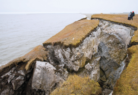
Torre Jorgenson, a geomorphologist working near Kaktovik, watched the storm boil up, shaking homes and boats for nearly two days in July 2008. Dramatic erosion followed soon after. Blocks of graphite-colored earth, as much as 10 meters wide and several meters deep, toppled into the sea one by one like skyscrapers in a Japanese monster film.
“The locals had never seen that type of erosion,” says Jorgenson, also president of the U.S. Permafrost Association. “It was something new, a regime change.”
The erosion Jorgenson witnessed was a potent warning to Kaktovik’s residents of the instability of their coastal home. Seaside bluffs and beaches across the Arctic are inhabited by indigenous northerners — such as Inupiat living in Kaktovik — as well as clutches of plants and animals that thrive in the cold air. But these shores are mercurial, crumbling away bit by bit with each season.
As human-driven climate change progresses, many fear that the Arctic’s coastlines will begin to break apart faster than ever. That’s bad news for the region’s human and other inhabitants. In 2009, the U.S. Army Corps of Engineers identified 178 communities struggling with erosion in Alaska, three of which have perhaps a decade before collapsing completely.
Though they provide shelter and sustenance, the Arctic’s coastlines haven’t received as much scientific attention as the nearby icy hills and seas, says geochemist Thomas Douglas. How these shores respond to, and possibly fuel, the changes accompanying global warming will be crucial for understanding the North’s future, he says.
“You can’t just take what sea ice people say or what tundra vegetation people say and just say, ‘OK, well, it’s the same on the coast,’ ” says Douglas, of the U.S. Army Cold Regions Research and Engineering Laboratory in Fairbanks, Alaska. “It is this zone of mixing basically amongst everything: Between ice and land. Between cold air and warmer air. Between where rivers meet the ocean.”
So international researchers are now working to develop a global view of the threats to northern coastlines. Recent collaborations have mapped current Arctic erosion rates, illustrating the wide variation in the land’s retreat. New data from Alaska show the complicated relationship between sea ice cover and erosion and suggest that, in some regions, land loss may already be gaining momentum. Teams of scientists are also working to estimate the nutrients carried in this eroding turf in an attempt to predict how sped-up erosion may alter coastal food chains. While the work moves forward, human communities scramble to defend themselves, or flee from receding shores.
Circling the pole
On some of Kaktovik’s calmer days, Jorgenson, who spends much of his time studying nearby shores, doubles as a science teacher, giving local schoolkids lessons on a familiar topic: erosion.
“I start out the class telling them we’re going to predict when your house is going to fall into the ocean, and their eyes all get really big,” Jorgenson says. “They’re really disappointed when we calculate it’s going to be 350 years.”
Each year, warm summer waters lap against Kaktovik’s bluffs, slowly pulling away dirt and rocks. This inchmeal progression is nothing new; the students’ parents and grandparents probably saw the coast trickle away bit by bit during their childhoods, too.
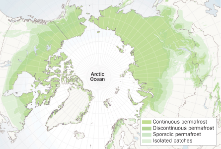
Scientists going back to the 1950s have monitored North America’s crumbling Arctic closely, says Hugues Lantuit, a geomorphologist at the Alfred Wegener Institute for Polar and Marine Research in Potsdam, Germany. Lantuit and his colleagues recently bridged decades of field studies with satellite data to draw what the team calls the most complete map of erosion across the Arctic, from Alaska to Greenland and Siberia.
The map reveals that Arctic land today falls back on average by about half a meter per year along more than 60,000 kilometers of twisting and winding coastline. These rates vary wildly depending on the beach or bluff in question, Lantuit’s team reported online in February in Estuaries and Coasts.
Drew Point, an exposed site on the Beaufort Sea, loses more than eight meters of land each year, for instance. Other studies have shown that nearby locales can collapse away by as much as 25 meters per year. Taken as a whole, these erosion rates may not differ drastically from those to the south, but temperate beaches don’t ice over in the winter, Lantuit notes.
“What is amazing is that you have those comparable rates even though you have only four months of open water in the Arctic,” he says.
The difference rests with the ice. Not in the water, but on land. Across much of the Arctic, the ground stays frozen year-round. Mix soil and water, shake up the slurry, then freeze it, and you get something akin to much of the Arctic’s frozen dirt, or permafrost. Some patches of Arctic ground along the Beaufort Sea are as much as 70 percent ice by volume. This ice-soil mix doesn’t just crumble when ocean waters lap. The water also licks the land like a Popsicle, causing the icy parts to melt. And where there’s more ice in the soil, there’s more melting and more bits of land being drawn seaward.
The team’s erosion map paints a vivid picture of how the Arctic quickly breaks apart under today’s processes. But many scientists fear that climate change may already be speeding up the region’s coastal dynamics, including erosion.
A swiftly moving Arctic
Soil scientist Jerry Brown was part of the first wave of scientists to explore the dynamics of Alaska’s frozen coasts in earnest. In 1963, he attended the inaugural International Permafrost Conference at Purdue University in West Lafayette, Ind. The event drew a number of scientists from North America and also a handful of Soviet scientists. The teams ate up each other’s coastal data, which had been until that point locked on either side of the Iron Curtain.
But global climate change hadn’t yet caught the attention of the scientific world, so its influences on erosion didn’t come up in conversation.
“We were just thinking of it as normal processes,” says Brown, who in 1983 helped to found a research collective called the International Permafrost Association.
At permafrost conferences today, the talk is different. Scientists agree that the Arctic will be among the first regions to show the toll of global warming. Alaskan and Canadian beaches aren’t yet balmy vacation destinations, but the average Arctic air temperature for the last decade is the warmest since 1900. Human-driven warming as well as natural climate shifts are probably combining to push the Arctic further away from its historic state.
Many researchers are now investigating whether Arctic shores will erode faster as beaches warm, and one especially vulnerable coastline may already be feeling the shrink.
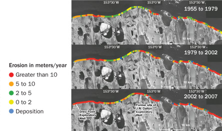
That coast, a stretch of the Alaskan Beaufort Sea west of Kaktovik, has never been calm. Features such as islands and points that dotted these shores when early explorers first mapped the coast have since disappeared. But shoreline fissures and crags may be growing increasingly more vulnerable. Recently, a team of U.S. researchers, including Jorgenson, collected a series of historic aerial photographs from a 60-kilometer span of the coast dating back to the 1950s and compared the photos with modern images.
When scientists started taking pictures here, land loss was proceeding at a fast clip, about seven meters per year. By 2002 to 2007, those rates had doubled to nearly 14 meters per year along these beaches, Jorgenson, Benjamin Jones of the U.S. Geological Survey’s Alaska Science Center in Anchorage and colleagues reported in Geophysical Research Letters in 2009.
“If we see like 15 meters a year … that’s a very dramatic number,” says Irina Overeem, a geomorphologist at the University of Colorado at Boulder who wasn’t involved in the 2009 study. “I don’t think there’s many sites around the world that match that.”
Overeem, who also monitors erosion in northern Alaska, has lost a lot of recording equipment to the encroaching sea. She is attempting to track the culprits behind the erosion that steals her gear, and the reasons for that erosion’s acceleration. Again, Overeem and other scientists have turned to ice for an explanation. In this case, though, the responsible ice doesn’t cover the land. During much of the year, it’s only accessible by boat.
Like a beating heart, sea ice expands around Alaska and then thaws away with the seasons. Despite these cycles, swaths of ice still commonly cling to the beaches during some summers. Or they did until recently. “In the last 15 years, that has not happened,” Overeem says. Instead, summer sea ice has stayed away from the shoreline for longer and longer. At certain sites along the Beaufort Sea, ice and land meet for about 50 days less each year than they did in the 1970s.
Ice loss fuels rising sea levels worldwide, but it’s particularly bad for local coasts. In cooler months, sea ice serves as the Arctic’s blanket, keeping an insulating layer between seashores and lapping waves. When coasts lose this blanket, those same waves lap and siphon away soil with abandon. In the Arctic, open water means quicker erosion, Overeem says. Along one stretch of the Beaufort Sea, the rates of erosion sped in tandem with lengthening open water seasons, she and colleagues reported in San Francisco last year at a meeting of the American Geophysical Union.
Less ice also means worse damage from storms, like the one that inundated Kaktovik in 2008, says storm scientist David Atkinson of the University of Victoria in Canada. Sea ice protects the coast from such catastrophes, which can tear down entire blocks of earth. On the simplest level, land-bound ice keeps waves from tearing at the shore. That blanket can also, however, keep waves from building up in the first place.
To make a big wave, Atkinson explains, winds need a lot of room to blow. Extensive sea ice leaves little open water — or fetch — to be had, and as a result, the surf has little room to gain momentum. “You might have a 100-mile wind, but if you only have a mile of open water fetch, you might only get 3-foot waves,” says Atkinson. But if the ice drops away tens of miles, “now the same storm can produce a much more damaging marine response.”
Because of these ice-erosion connections, how much land the Arctic stands to lose probably depends on future ice melting there. And the future looks grim, says James Overland, an oceanographer with the National Oceanic and Atmospheric Administration’s Pacific Marine Environmental Laboratory in Seattle.
2007 was not a good year for ice forecasters such as Overland. A freak weather pattern sent warm winds blowing north, melting swaths of sea ice already weakened from years of steady temperature increases. As a result, summer ice extent shrank to a record low level, nearly 40 percent below the historic average. Regions that were once dependably capped with ice all year turned slushy. “Essentially, we were really unlucky in 2007,” Overland says.
The coast’s protective blanket may never recover, Overland says. He suspects it would take just two more bouts of extreme weather, similar to that seen in 2007, to get rid of most of the remaining summer ice across the entire Arctic. In a paper published in 2009 in Geophysical Research Letters, Overland and a colleague forecast that Arctic summers would be largely free of sea ice by 2037.
“The Arctic really is the canary in the coal mine for global change,” Overland says.
Bracing for change
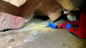
Along the Arctic coast, that change has been a muddy affair for scientists. Sloughing permafrost can form what Donald Forbes of the Geological Survey of Canada in Dartmouth, Nova Scotia, calls a “big amphitheater” with tall, ice-rich walls. These amphitheaters collect wide pools of mud at their bases — researchers stepping in the wrong spot often find themselves up to their waists in the muck.
Such mud pools are erosion at its dirtiest, and some scientists are now wondering if the dirt will disrupt marine life as much as it disrupts research. Falling cliffs dump a lot of soil into the water, providing potential nutrients like carbon and nitrogen to nearby organisms. Jorgenson and his colleagues estimated that along 2,000 kilometers of the Beaufort coast, 150 million kilograms of organic carbon dumps into the sea annually. That’s about as many nutrients as flush out of all the rivers along that same stretch of coast combined, the team reported in April in the Journal of Geophysical Research.
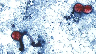
Early studies have shown that all that dirt does wind up in the bellies of many shallow-water critters. But exactly which organisms eat the turf food first, and how much of it gets eaten, isn’t clear, says Kenneth Dunton, an ecologist at the University of Texas at Austin’s Marine Science Institute in Port Aransas. Without knowing the path that carbon takes through the Arctic food web, scientists can’t be sure how bigger soil buffets will affect coastal ecosystems, he says.
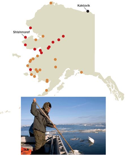
The future for human communities across the Arctic is similarly murky. Kelly Eningowuk grew up in the village of Shishmaref, built on a sandy and inherently unstable island on the Bering Strait. A wide beach once sat between Shishmaref and the cold waters beyond. During Eningowuk’s childhood in the 1980s and 1990s, however, erosion removed all but a narrow strip of that shoal. Today, several buildings, including tanneries and a classroom, risk collapsing into the ocean entirely.
Shishmaref is one of the three Alaskan communities that the U.S. Army Corps of Engineers has said faces particularly dire erosion rates. The village elected to migrate to a new site a few miles inland, what Eningowuk calls “the ultimate adaptation.” Ultimate and pricey. From start to finish, the relocation could cost up to $200 million, the Army Corps has estimated.
The cultural costs of a changing climate may be equally high. For Inupiat, hunting by ice cements the bonds between fathers and sons learning how to safely stalk seals and the bonds among women who help butcher the quarries. “It’s so much more than food,” says Eningowuk, now executive director of the Alaskan branch of the advocacy group the Inuit Circumpolar Council. “It’s really our identity. I can’t imagine not having it.”
Inupiat are adaptable, Eningowuk says, but changes will come fast. That reality became clear to her a few years ago after a near tragedy. Her grandfather, Delbert, had hunted seals and walrus just off Shishmaref since he was a young man and he knew as well as anyone how to read ice, distinguishing safe from weak footing. But, at nearly 80, he fell through a patch of spring ice into the freezing water, surviving by a stroke of luck. “If he can’t read what’s going on,” Eningowuk says, “obviously it’s changing so fast.”
Rising temperatures in the Arctic, of course, will affect more than small villages like Kaktovik or Shishmaref. Despite its remoteness, the Arctic is still tightly connected to the rest of the world, says Volker Rachold of the International Arctic Science Committee in Potsdam. With this global view, erosion, intrinsically tied to sea ice, isn’t just a problem for Northern peoples, he says. As ice melts around them, sea levels will rise along warm and cold ports alike; the Arctic is, in many ways, the planet’s thermostat.
“It’s not only that things are happening much faster there,” Rachold says. “It’s also that things happening in the Arctic have a direct impact on the rest of the globe.”