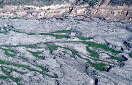
Just a stone’s throw north of Mount St. Helens, the oddly hummocky terrain is covered with a patchwork of vegetation and small ponds. Sediment-rich rivers thread through and meander across floodplains once hidden beneath lush, tall forests. Although harshly pruned in the recent past, the region’s tree of life is beginning to sprout with vigor.
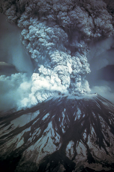
It has been nearly 30 years since the largest volcanic eruption ever observed in the lower 48 states pulverized the top of Mount St. Helens into a roiling cloud of rock and ash. A 550-square-kilometer swath of the Pacific Northwest — an area about three times the size of the District of Columbia — was almost immediately transformed from vibrant ecosystem to denuded wasteland.
In the decades since, the region has been a natural laboratory for studying the processes that bring life back in the aftermath of devastation. Ecological recovery has proceeded more quickly than many scientists thought possible, but has nevertheless been a slow and halting affair.
Ecologists have been especially struck by how important the time and season of the eruption — a roughly nine-hour episode that began a little after 8:32 a.m. on May 18, 1980 — has influenced the mountain’s ecological rebound. The severely winnowed mix of flora and fauna living in the shadow of the peak today has been largely determined by what survived that mid-spring morning, ecologists note. The region’s ecosystems may not resemble those in place before the eruption for a couple of centuries.
A cataclysm commences
When most people think of a volcanic eruption, they think of a mountain blowing its top. But on that spring morning, Mount St. Helens — the youngest and most active major volcano in the Cascades — blew its side. It was not a simple eruption but a concatenation of ruinous events that utterly transformed the landscape.
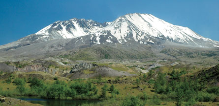
The peak itself was profoundly changed. Mount St. Helens had been 2,950 meters (9,677 feet) tall, snowcapped and beautifully symmetric — so much so that the dormant volcano was often called America’s Mount Fuji, a reference to Japan’s tallest and most revered peak. That all changed when the eruption trimmed about 400 meters off the summit of Mount St. Helens and left a 1.5-kilometer–wide, amphitheater-shaped crater.
The peak’s former symmetry stemmed from its geological youth, says Michael A. Clynne, a geologist with the U.S. Geological Survey in Menlo Park, Calif. Most material in the volcano’s facade had erupted during the last 3,900 years, so the forces of erosion hadn’t had much time to sculpt the flanks of the peak.
“Mount St. Helens is the baby volcano of the Cascades,” says Scott F. Burns, a geologist at Portland State University in Oregon.
Like many youngsters, the mountain has frequent and erratic outbursts. Dozens of eruptions have occurred in distinct clusters over the past 45,000 years, separated by lulls that last anywhere from about 2,000 to 8,000 years.
“This is clearly the most active of the major Cascade volcanoes; there’s no doubt about that,” says Clynne.
Most eruptions, he notes, are mild affairs more akin to the one that began in 2004, when molten rock oozed into the crater floor to heighten the lava dome that’s rebuilding the peak.
But every once in a while, Mount St. Helens blows itself sky high.
The 1980 eruption started with a rumble, when a magnitude 5.1 quake deep inside the volcano triggered the largest landslide ever witnessed. About 2.5 cubic kilometers of the peak’s northern flank — a snow-dappled slope that for weeks had been bulging outward a couple of meters more each day — sloughed away and raced downhill at speeds that may have exceeded 200 kilometers per hour.
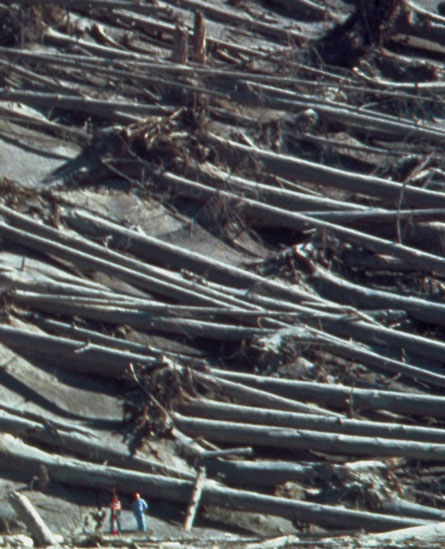
The sudden release of pressure was like uncorking a bottle of champagne. The blast of hot, stone-filled wind that surged northward over the rugged, forested terrain destroyed or damaged enough timber to build 150,000 wood-frame homes. The rock mixed with and melted snow and ice that had been carried from the peak, creating debris flows called lahars with the consistency of wet cement. As these lahars swept down rivers and streams, they scoured the sinuous, treelined waterways into straight-channeled, lifeless and sediment-choked torrents.
Material carried by the largest of these lahars, which flowed into the North Fork Toutle River valley just north of the volcano, buried a 60-square-kilometer area to an average depth of 45 meters and disrupted drainage patterns throughout the watershed. Heat from the volcanic ash in that freshly deposited blanket — a landscape that some scientists call “the pumice plain” — vaporized groundwater in the underlying soil, triggering blowouts of steam that excavated craters up to 400 meters across.
Life returns
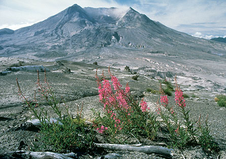
Some researchers feared the area north of the volcano would remain a sterile moonscape for decades. But scientists studying the blast-seared zone north of the peak found vegetation on the landslide within a few years, says Peter Frenzen, a U.S. Forest Service biologist at the Mount St. Helens National Volcanic Monument.
Nine years after the eruption, plants had returned to just over 10 percent of the hummocky terrain. Twenty years on, vegetation had expanded to cover about two-thirds of the deposit. Today, Frenzen says, about 80 percent of the once sterile area sports vegetation.
Some of the first plants to return were lupines, most of which are perennial plants that add nitrogen to the soil. Because that nutrient and many others aren’t present in volcanic ash, such nitrogen fixers form the vanguard for species that can’t produce nitrogen and can’t get it via symbiosis with creatures that can. Field studies done 20 years after the eruption dramatically make the point: In areas where lupines thrived, the amount of organic material in the soil and in subterranean microbes was about four times that found in areas without lupines, Frenzen notes.
Nitrogen-fixing tree species like red alder (Alnus rubra) still predominate on the landslide debris. Dense thickets of this fast-growing species have sprouted where groundwater is available and have literally overshadowed slow-growing conifers such as Douglas fir and western hemlock, Frenzen says. Only when the fast-growing trees mature, die and fall over — a process that will take decades — can the suppressed conifers rise to prominence, he adds.
Many factors have influenced the rate at which plants repopulated the landslide deposits. For example, plants with seeds carried by wind or by highly mobile creatures like birds moved into the blast zone faster. And because most plant species recolonized the blast zone from its edges, slender swaths of devastation such as the deposits in the relatively narrow North Fork Toutle River valley were colonized sooner than broad areas like the pumice plain near the base of the volcano.
Animal recovery on landslide deposits has been slow as well. Field surveys before the 1980 eruption noted 15 amphibian species in the area, says Frenzen. The eruption wiped them all out; scientists surveying one wetland site on the avalanche debris didn’t spot any amphibians at all until three years after the eruption, when researchers found two species: Bufo boreas, the western toad, and Pseudacris regilla, the Pacific tree frog. Even today, no more than a handful of the region’s original amphibian species dwell on the landslide debris.
Creatures living in ice-capped lakes at the time of the eruption had better chances of survival, as did subterranean creatures and small animals such as pocket gophers. Many migratory creatures had yet to return to the area for breeding or spawning season that year, so they were never at risk.
And because the event occurred mid-morning, fortune smiled on nocturnal creatures, many of which had returned to their daytime hideouts before the mountain roared.
Today, some parts of the blast-scarred region teem with the highly mobile creatures that quickly recolonized the transformed ecosystem. Killdeer and red-winged blackbirds thrive along the densely thicketed edges of lakes and small ponds where beaver busily harvest trees to build lodges and dams. Herds of elk forage the open valleys, and hawks dive-bomb for rodents alongside fish-snatching osprey.
Muddy waters
Yet ecological recovery along waterways with unstable channels has been spotty. On some hillsides, fresh wounds appear where massive slumps of unconsolidated ash have spilled from the mountain and wiped the slate clean. These denuded areas, as well as the immense amounts of ash and sediment still slathering the region’s floodplains, boost the amount of silt in rivers and streams.
That’s especially true along the floodplain of the North Fork Toutle River, says Jon Major, a hydrologist with the U.S. Geological Survey in Vancouver, Wash. Because erosion is constantly sculpting the loose material left by the landslide and subsequent lahars, plants — especially perennials that require stable soil — have had a tough time gaining a foothold.
That dearth of vegetation has helped keep the sediment load in the river high. Just after the eruption, each liter of river water held several hundred times the amount of sediment it carried before the event. Even today sediment load is 50 to 100 times pre-eruption levels. Other rivers that drain the peak still carry about 10 times the sediment they did before the eruption, Major says.
Although the loose material already on the floodplains may be the major contributor to this increased sediment load, another source may be the steep flanks of the volcano itself. “Ever since the May 18 eruption of 1980, that mountain has been pumping out debris flow after debris flow,” says Portland State University’s Burns.
The material in those slumps comes from two main sources, he notes. One is the immense volume of fractured rock that fell back to Earth after being hurled skyward in volcanic plumes during the May 18 and subsequent eruptions. The other is the halo of glacier-scraped bits left behind as the peak’s ice masses — which somewhat
stabilized the material — retreated upslope, both in the wake of the eruption and as climate has warmed in recent years. “When you climb the mountain, the last hour or hour and a half is two steps up, one step down, two steps up, one step down,” Burns says. “This stuff is two or three feet thick, and that’s the type of material that’s being mobilized.”
Prodigious sources of loose glacial sediment can be found on all Cascade volcanoes, Burns reported in Portland last October at the annual meeting of the Geological Society of America. “You have the material, you have the steep slopes, you have no vegetation to hold the material in place, and all you have to do is add water,” he says.
The landslide risk from that material will only increase if the climate gets warmer in coming decades, he speculates. Retreating glaciers have already exposed immense quantities of loose sediment that had accumulated on the volcano’s flanks before the eruption, and a shorter snow season means that the material will be exposed to erosion-causing rains for more time each year.
Beginning this summer, Burns and a few of his graduate students will be surveying Mount St. Helens, mapping the volumes and locations of its loose material and then creating a map depicting the risks of landslides. “It’s going to be a lot more extensive than we’d thought before,” he notes.
Researchers will document the recovery of the terrain around Mount St. Helens for generations to come as ecological succession gradually restores the dense old-growth forests that covered the area before the eruption. And though the chances of another major eruption during that time are slim, someday Mount St. Helens will explode again, smothering the landscape in a mantle of ash and beginning the process anew.
Predicting if what goes up will fall back down
Even after 30 years, scientists are gleaning fresh insights from images taken during Mount St. Helens’ latest major eruption. New studies of photos and video shot that day may help volcanologists predict whether an ash plume rising into the stratosphere might be on the verge of collapsing back to Earth in a rain of debris.
From 11 a.m. to about 12:15 p.m. on the day of the 1980 eruption, Mount St. Helens spewed up to 13,000 metric tons of hot gases and rock each second. During that interval the plume over the peak could pull in enough air to be fully buoyant, like smoke going up a chimney. Images taken that morning show that the swirling eddies around the edges of the plume measured about 560 meters across.
But much of the plume collapsed from 12:15 p.m. to around 4:25 p.m., as the volcano’s vent widened and mass flow through the crater more than tripled. Instead of rocketing skyward, pyroclastic flows of hot gas and rock rolled down the mountain’s flanks. During this phase the ash plume’s eddies measured, on average, only 370 meters across. Researchers speculate that the plume collapsed because these smaller, more tightly spaced swirls couldn’t pull in enough air to keep the rising pillar fully buoyant.
“The real trick for an ash plume is to incorporate enough air to become buoyant before it loses its upward momentum and collapses,” says James E. Gardner, a geologist at the University of Texas at Austin.
Now, for the first time, recent analyses of images captured that day provide vital clues about what happens inside a volcano’s thick ash plume, he and colleague Benjamin J. Andrews report in the October 2009 Geology.
Although the May 18 eruption is one of the best documented eruptions in history, scientists don’t have images showing the ash plume’s transition, says Gardner. So, he notes, it’s not possible to discern how quickly that transition took place or whether the plume displayed advance warning of its impending collapse.
It’s tantalizing to think that scientists could spot early indications that a plume was on the verge of falling back to Earth, says Gardner. And even though data from Mount St. Helens can’t answer that question, he notes, his team’s findings nearly 30 years after the explosion open up new avenues for studies of future eruptions.