Ground shakes expose faraway earthquake hot spots

Slowdown in seismic waves map areas with temblor ingredients: weakened rock, fluid buildup

map of costa rica

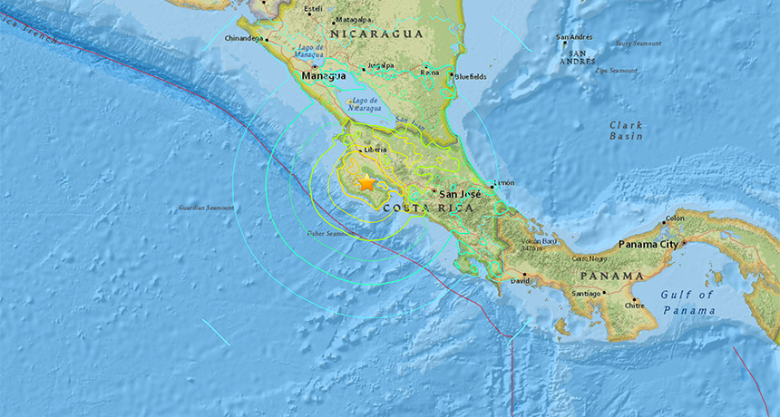
WEAK SPOTS   A magnitude 7.6 earthquake that shook Costa Rica in 2012 revealed earthquake-prone weak spots in Earth’s crust, new research shows. Colored lines mark the intensity of shaking felt at that location from the epicenter (star), with yellow lines marking the more intense shaking.

USGS Earthquake Hazards Program

Rumbling earthquakes could reveal faraway weak spots in Earth’s crust.

Following a 2012 earthquake that rattled Costa Rica, researchers noticed that the quake fractured underground rock tens of kilometers from its epicenter. Before the quake, that fractured region had already been weakened by pressurized fluids mixed in with the rock, the researchers propose online January 8 in Science Advances. Such weakened patches are more prone to shift and set off major earthquakes. So monitoring where future quakes fracture rock will help scientists better understand how the fluids that help spawn earthquakes disperse around Earth’s crust, says study coauthor Esteban Chaves. That could let seismologists better forecast where titanic tremors are likeliest to strike.

“If we can characterize the structure of seismic faults, we can better understand why earthquakes behave the way they do,” says Chaves, a seismologist at the University of California, Santa Cruz. “We can then revise building codes or evacuate people. The ultimate goal is to save lives.”

Costa Rica’s Nicoya Peninsula sits over the boundary where the Cocos tectonic plate slips beneath the Caribbean Plate at a rate of about 85 millimeters per year. This subduction doesn’t always go quietly: Every 50 to 60 years, a sudden movement along the boundary generates a colossal quake.

After the 2012 earthquake, Chaves and seismologist Susan Schwartz, also at UC Santa Cruz, sifted through Earth’s seismic background noise to hunt for impacts the tremors had on nearby rock. That background noise includes plenty of smaller vibrations that rumble through the ground from sources such as ocean waves, large trucks and even cows meandering through nearby fields. Filtering out the human and bovine contributors to this noise, Chaves and Schwartz combined data from several seismometers to track how quickly the non-earthquake–related vibrations rattled across the peninsula.

In one region on the opposite side of the peninsula from the quake’s epicenter, the researchers found that seismic waves traveled about 0.6 percent slower after the big quake. While that slowdown might not seem like much, it’s a “huge” decrease seismologically speaking, Chaves says. He proposes that the earthquake opened gaps in already-weakened rock. Those gaps cause seismic waves to take longer to pass from one side of the area to the other.

Previous work showed that this area of the peninsula contained highly pressurized fluids. These fluids migrate underground alongside the sinking tectonic plate and weaken rock by counteracting the squeezing forces that hold the rock together (SN: 7/11/15, p. 10). Accumulating fluid can help trigger earthquakes by causing rock under pent-up strains to break and slide, shaking the ground.

Monitoring seismic wave slowdowns elsewhere could help seismologists track where and how fluids move around and weaken the Earth’s crust, Chaves says. “This is going to change the way we see subduction zones and the way we use ambient background noise,” he says.

The new work confirms that fluids significantly weaken rock, something seismologists have long suspected, says seismologist Pascal Audet of the University of Ottawa. “This work shows that fluids play a big role before, during and after an earthquake has occurred and even in the generation of an earthquake,” he says. “This will help us identify regions that may be weakened by fluids and be more prone to bigger earthquakes.”

More Stories from Science News on Earth

From the Nature Index

Paid Content