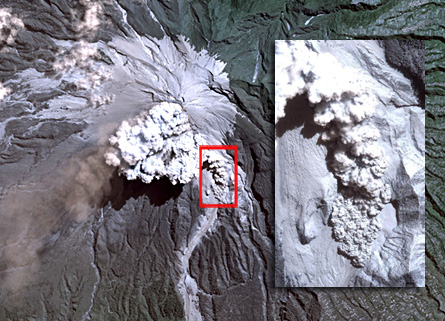
An image of a pyroclastic flow, one of the quickest and deadliest phenomena related to volcanic eruptions, has finally been caught by a satellite. These ground-hugging avalanches of hot ash and rocks can sweep down a volcano’s slopes at more than 100 kilometers per hour. They last no more than a few minutes, says Avijit Gupta, a geomorphologist at the University of Leeds in England. Luckily, he notes, the ground-gazing IKONOS satellite was passing over Indonesia’s MountMerapi while it was erupting on June 16, 2006. Although scientists previously have tried to detect pyroclastic flows in satellite images, “normally the ash cloud over the volcano blocks the view,” he says. In this instance, strong winds blew the ash plume westward, revealing the flow, Gupta and his colleagues report in the May 27 Eos. The serendipitous image captured the pyroclastic flow when it was about 500 meters long, between 250 and 500 meters wide, and 50 meters high.


