Monster storm dominates view from space station

Snapshot shows powerful Typhoon Maysak from space

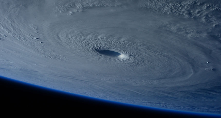
EYE OF THE STORM  Typhoon Maysak’s gaping eye offered an impressive sight for astronauts looking down from the International Space Station.

S. Cristoforetti/ESA, NASA

Looking down from 400 kilometers above Earth, astronauts aboard the International Space Station couldn’t help but gawk at a huge typhoon churning in the Western Pacific. On March 31, European Space Agency astronaut Samantha Cristoforetti captured this photo of Typhoon Maysak at near-peak strength as it drifted toward the Philippines.

Maysak was the record-breaking second major cyclone to form in the Western Pacific before April, the typical start of the region’s typhoon season. Packing winds exceeding 200 kilometers per hour, the storm swirled about a well-formed eye that Cristoforetti’s crewmate Terry Virts compared to “a black hole from a sci-fi movie.” The typhoon killed five people and caused extensive damage in the Federated States of Micronesia.

The unusually intense preseason typhoons may have stemmed from El Niño, an eastward shift of warm water in the Pacific. Sea surface temperatures that were 1 to 2 degrees Celsius above average provided more fuel for budding storms. On April 9 the National Weather Service estimated that El Niño conditions have a 70 percent chance of continuing through summer. If El Niño sticks around, Maysak may prove a harbinger of a perilous typhoon season. 

More Stories from Science News on Climate

From the Nature Index

Paid Content