Researchers create global map of tree height

Mapping changes over time could help track forest carbon content

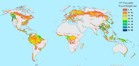
Scientists have created the first global map of forest height using satellite data. The map will improve estimates of how much carbon is stored in Earth’s trees and how much carbon dioxide they absorb from fossil fuel burning annually.

This color-coded map shows the height of the world’s forests, from the tallest (blue) to the shortest (red). Light gray patches are non-forest areas where trees cover less than 70 percent of the surface. Courtesy of M. Lefsky

Trees store carbon through photosynthesis by converting carbon dioxide from the atmosphere into biomass. This process helps absorb some of the 7 billion tons of carbon dioxide that people release into the atmosphere every year. But it’s not clear exactly how much carbon goes into trees, and it’s difficult to predict how much they will soak up in the future.

“There’s this persistent question of the missing carbon sink,” says lead researcher Michael Lefsky, a remote-sensing scientist from Colorado State University in Fort Collins. “There is a disconnect between what we think is being absorbed by the terrestrial environment and what’s turning up in the atmosphere.”

One way to solve the puzzle is to measure tree growth over time. From that, scientists can directly calculate how much carbon has been absorbed.

To measure tree height around the globe, Lefsky used lidar data from a satellite orbiting 600 kilometers above Earth. Lidar, short for light detection and ranging, uses lasers to measure the distance from the satellite to points on Earth’s surface.

The lidar instrument shoots laser pulses toward Earth and measures how long the light takes to bounce back to the satellite. Light that hits the ground takes a bit longer to bounce back than light that hits trees, and this difference allows scientists to calculate forest height to within 4 meters. Lefsky used 250 million lidar measurements accumulated by NASA’s ICESat satellite over seven years. He confirmed the data were correct by comparing them to on-the-ground field measurements and more accurate lidar surveys from airplanes.

But lidar data covered only about 2.4 percent of the Earth’s total surface. To predict tree height in the remaining surface area, Lefsky matched the lidar data with color images from two other satellites. Based on surface color, he could predict tree height for the rest of the planet’s forests. The resulting map, which will be published in Geophysical Research Letters, gives the tree height of all of the world’s forests.

“As these maps improve, they are going to give us our first good total biomass for the Earth’s forests,” Lefsky says. When combined with satellite images of forest isturbance, such as fire or logging, “we’ll have a better sense of how much carbon is being released from land-cover change.”

Scientists who study species diversity may also benefit from the map, because it shows variation in forest composition.

“More diverse forests might have more niches for species to inhabit,” says program scientist Woody Turner from NASA headquarters in Washington, D.C. “It points people to interesting areas to dig deeper, to look under the canopy and see what’s there.”

But to measure changes in forest height, researchers will have to keep updating the map.

“It’s difficult to directly use these maps to see where the carbon goes and where it comes in, because this is a map for one time period,” says remote sensing scientist Kaiguang Zhao of Duke University in Durham, N.C. “If you continue to map for 10 to 20 years, such maps will be very valuable to characterize the dynamics of above-ground carbon.”

A new satellite mission scheduled for 2017, called DESDynI, will take both lidar and radar measurements over a shorter amount of time to improve the map’s resolution.

“We can contemplate producing a carbon map every year, rather than waiting for all this data to accumulate,” says Lefsky. “That will give us an opportunity to look at the amount of carbon being taken up over the year.”

In the meantime, he says, researchers can fill in data points with satellite radar to improve the map’s resolution.

More Stories from Science News on Earth