When the ground quakes, scientists as well as everyday folk take notice. By analyzing motions recorded by hundreds of seismometers during dozens of quakes, researchers have compiled a new and improved geological model of Southern California’s crust. The resulting high-resolution model is much like a CT scan of the earth and will enable more accurate estimates of seismic hazards in the region, scientists report.
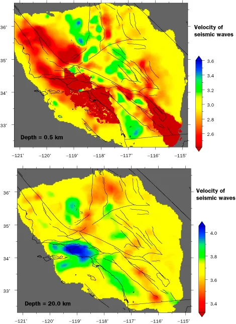
Seismic vibrations travel through some types of rock more quickly and with less damping than others. Such variations have to be taken into account when pinpointing the epicenter of a quake, says Carl Tape, a seismologist at California Institute of Technology in Pasadena. In the Aug. 21 Science, Tape and his colleagues describe the enhanced model of Southern California’s crust built with data gathered by the dense network of seismic instruments in the fault-ridden region.
In their study, the researchers used an existing 3D model of the region’s crust to compute the ground motions expected to result from each of 143 quakes. Then, the team compared those theoretical seismograms with actual data — including the size, shape and arrival time of various types of seismic waves — recorded by instruments during those quakes. When predictions differed substantially from actual data, material properties in the model, such as the density of the rock in the crust, were adjusted. After 16 iterations, differences between actual and simulated ground motions were minimized, the researchers note.
Results of the team’s study “are absolutely fantastic,” says Guust Nolet, a geophysicist at the University of Nice in Sophia Antipolis, France. While scientists previously have been able to tweak geological models to accurately reflect the arrival times of a quake’s ground motions, they haven’t been able to adjust the model to accurately predict the size of those motions. “We’ve never been able to solve the problem for an entire seismogram,” he notes. Besides having a higher resolution and more precise values for rock characteristics, the new model should allow better predictions of interactions among seismic waves that can wreak substantial damage, he adds.
In several locales, the new model provides substantially different data from the old one, Tape says. For instance, the new analyses indicate that seismic vibrations actually travel about 35 percent slower than had been thought under parts of the southern San Joaquin basin, the region around Bakersfield. That finding suggests that the sediments there are looser than previously suspected. Also, the traveling speeds of seismic vibes in the western Mojave Desert, east of Barstow, have been revised: While those moving at depths of three kilometers or less and those transiting depths between 18 and 24 kilometers travel faster than had been thought, the vibrations moving through the area at depths between 5 and 15 kilometers are now known to move substantially slower.
The new model will help seismologists better locate the epicenters of quakes, thereby improving the identification of faults along which those quakes originated. By providing more accurate predictions for ground motions that might be experienced at any particular spot, simulations will enable scientists to better estimate seismic hazards, Tape says.


