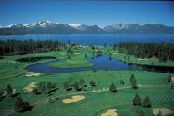
Postcards from Lake Tahoe all flaunt a peaceful, brilliant-blue stretch of mountain water. But geologists have been snapping a very different picture of the lake lately. Far beneath Lake Tahoe’s gentle surface, they say, several hidden earthquake faults snake across the lake’s flat bottom. These faults put the lake at a bizarre risk for an inland body of water.
If the researchers are right, Lake Tahoe tourists could one day feel the ground tremble and, just minutes later, face a tsunami. Roiling waves of water would crest to 10 meters at the shore and crisscross the lake for hours.
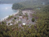
Tsunamis typically emerge in oceans, usually after a quake drops or lifts part of the seafloor. Undersea landslides—alone or following a quake—can also trigger these giant waves. In 1998, for instance, a tsunami devastated Papua New Guinea, sweeping away more than 2,000 people living on the country’s northern coast (SN: 8/1/98, p. 69: http://www.sciencenews.org/sn_arc98/8_1_98/Fob3.htm). And in the past decade, tsunamis have lashed the coasts of Japan, Nicaragua, and Indonesia, as well. But Lake Tahoe?
While it may seem improbable, Lake Tahoe holds just the right blend of ingredients to brew a tsunami. For one thing, it has plenty of water. As the world’s 10th-largest lake, Lake Tahoe stretches 35 kilometers long, 19 km wide, and, in some spots, 500 m deep. What’s more, the lake sits smack in the middle of earthquake country, nestled in a fault-riddled basin that straddles California and Nevada. Dozens of minor or moderate quakes erupt along faults in the region every week, and the Lake Tahoe area is no exception. All it would take, scientists say, is a strong quake directly beneath the lake to send the waters spewing, tsunami-style.
To get a better grip on Lake Tahoe’s tsunami potential, University of Nevada, Reno geologists have been modeling different quake scenarios. According to their calculations, if a magnitude 7 quake struck either of two major faults under the lake, the bottom could open like a trapdoor, with a chunk of it suddenly dropping as much as 4 m. Just behind it would fall a huge, sinking slosh of water—generating a giant wave that would reach the surface, gather strength, and come barreling to shore as a tsunami.
And that’s just the beginning. The scientists think the tsunami, in turn, would create so-called seiche waves, mountainous waves that lurch from shore to shore for hours on end. “Think of the lake like a pan full of water. When you knock one end way down, the water surges and then sloshes back and forth for some time,” says Gene A. Ichinose, a geophysics graduate student at Nevada-Reno and lead author of the group’s study, which appeared in the April 15 Geophysical Research Letters. As in a jostled pan of water, some waves would likely splash past their usual borders—right into the homes and hotels that dot the Lake Tahoe shoreline.
As Ichinose puts it, “If you feel the earth shaking for 5 or 10 seconds, get to high ground.”
Grainy litter
Inland tsunamis are extremely rare. Last year, geologist Jody Bourgeois of the University of Washington in Seattle reported evidence of a prehistoric tsunami in Possession Sound, a small body of water off Puget Sound. Bourgeois and her colleagues found a 2-centimeter-thick layer of sand smeared over a fossilized marsh in the area. It’s the remnant, they say, of a tsunami that rolled in, picked up sand and debris, and then dumped the grainy litter right on top of the marsh. Their analysis is similar to that being used to detect ancient hurricanes (SN: 5/20/00, p. 333: Hunting Prehistoric Hurricanes).
The Seattle team’s radiocarbon dating of the sediment layers places the tsunami between A.D. 800 and 950. This period coincides neatly with a large quake that struck a fault in Seattle, 30 miles to the south, between A.D. 900 and 930.
More recently, the surf came up at Hebgen Lake in Yellowstone National Park. Just before midnight on Aug. 17, 1959, a magnitude 7.5 quake struck nearby, sending a landslide into the lake and churning a series of seiche waves as high as tall trees that reportedly crashed from shore to shore for almost 12 hours before quieting.
In other lakes, at other times, landslides and rock avalanches have generated waves twice that high, according to reports of the U.S. Geological Survey. The Army Corps of Engineers frequently checks the strength of the dams on lakes in high-risk places. Moreover, in 1980, a U.S. Bureau of Reclamation study modeling quake hazards prompted efforts to shore up a dam at Lake Tahoe.
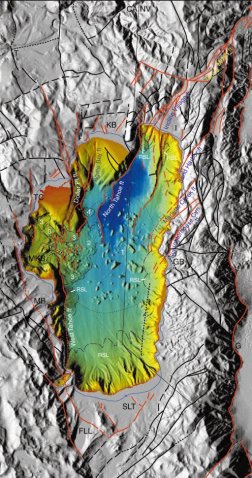
Until now, however, scientists haven’t known just how a tsunami at Lake Tahoe might play out. Some clues emerged 2 years ago, when USGS researchers mapped Lake Tahoe’s floor using sonar. Sending a small burst of sound into the lake, the team gauged the lake’s depth at a specific point by measuring how long that pulse took to reach bottom and then reflect back. Applied in a pattern across the lake, this sonar bathymetry allowed scientists to draft a 3-D map of the lake bottom. The picture that emerged wasn’t peaceful.
While most of the lake floor is flat, parts are littered with huge rocks jumbled every which way. This debris, geologists say, came from a landslide in which one wall of the lake collapsed, possibly within the past 10,000 years. Given the location of the debris, it’s likely that a quake along one of the underwater faults triggered the landslide—and also a tsunami, says Richard A. Schweickert, one of a team of Nevada-Reno geologists who used the USGS sonar data to help create a fault map of Lake Tahoe last year.
“Most people think of lakes as places where sediment quietly accumulates, little by little, over thousands of years,” Schweickert says, “but this suggests a much more catastrophic process at work.”
Underwater faults
If catastrophe struck Lake Tahoe once, why not again? “It’s definitely a valid hypothesis,” remarks geologist Craig M. dePolo of the Nevada Bureau of Mines and Geology in Reno. “It’s clear there are faults right below the lake. And if they move, the lake will respond.”
It’s reasonable to assume that the faults lying beneath Lake Tahoe are similar, Ichinose says. If so, they probably crack open about once every 1,500 years with a magnitude 7 quake that lifts or drops part of the lake floor by 4 m. Armed with these quake parameters, Ichinose and his colleagues cranked out computer simulations to learn how the lake would react.
According to one scenario, a quake along the fault under the north end of the lake would send waves up to 6 m high racing toward the community of South Lake Tahoe on the southern shore. In a second scenario, a shift in the fault that runs along the lake’s west side catapults 10-meter-tall waves into McKinney Bay on the western shore. In both cases, the initial tsunami gives way to dangerous seiche waves, which can be just as high as the tsunami and roll back and forth for hours.
The good news, geologists say, is that a magnitude 7 quake under Lake Tahoe only has a 3 to 4 percent probability of striking in the next 50 years, given the 1,500-year quake-recurrence interval inferred from tremors along the Genoa fault. “If I were fortunate enough to own a lakeside home, I wouldn’t sell it now,” remarks John G. Anderson, head of Nevada-Reno’s seismology lab and a coauthor of the modeling study.
By comparison, people living in San Francisco face a roughly 70 percent chance of a similar-size quake in the same timeframe.
Still, the risk at Lake Tahoe is high enough to warrant further study, says oceanographer Harold Mofjeld of the National Oceanic and Atmospheric Administration’s Tsunami Research Program in Seattle. “Our main concern would be the tourists, who might not be prepared for an event like this,” says Mofjeld. “If residents knew what to expect, they could probably get to high ground in time.”
Though a quake lasts just seconds, a tsunami wave could take up to 15 minutes to reach Lake Tahoe’s shore. That would be plenty of time for many people to scramble up a mountainside, adds Ichinose. He worries more about the lingering seiche waves, which could surprise folks returning home.
Lake Tahoe is now on a growing list of tsunami-risk sites in the United States. For years, researchers viewed tsunamis as disasters rolling in from a distant shore—arriving in Hawaii, say, after rearing up on the coast of Alaska. While still deadly, long-distance tsunamis typically give U.S. coastline communities time to react.
In the past few years, though, U.S. scientists have found more and more tsunami hazards at their doorstep. The new worries began when geologists discovered that the Papua New Guinea quake was centered on land, not at sea, as first thought. That suggests the quake didn’t directly spark the subsequent tsunami but instead launched an undersea landslide that generated the giant waves.
It so happens that the U.S. West Coast, from California to the Pacific Northwest and southern Alaska, has many similar spots. Coastal faults there could trigger moderate quakes, which would launch nearby underwater slides and then tsunamis. This cascade of events may have caused an 1812 tsunami in Santa Barbara, for example.
The West Coast isn’t the only area facing potential waves. In the May Geology, scientists report finding pockmarks on the continental shelf off Virginia and North Carolina. They appear to be scars from gas exploding through the seafloor. If these gas blowouts continue, the researchers say, the weakened shelf edge might collapse, sparking a landslide and tsunami that would flood part of the coast, including the Chesapeake Bay.
Living proof
Back at Lake Tahoe, scientists are working to confirm that prehistoric tsunamis really did surge from earthquakes or landslides. “Finding physical evidence, or actual tsunami deposits, would help the researchers make their case that a future tsunami is possible,” says Bourgeois. “That kind of living proof is also good for raising the awareness among the public and hazard planners.”
Perhaps the same prehistoric, quake-triggered landslide that dragged rocks across Lake Tahoe’s floor also hurled a tsunami across its shores. To test that hunch, Schweickert’s team plans to date both the potential tsunami deposits and some lake-bottom sediments cut by the west Lake Tahoe fault, perhaps linking the disasters in time.
Proving a prehistoric tsunami at Lake Tahoe won’t be easy, cautions dePolo. In any situation, he says, it’s tricky to show that today’s sandy layer came from yesterday’s tsunami.
“What we’re looking for is a beach that’s been picked up by the water, taken to maximum wave height, suspended, and then dumped, along with debris, just before the waves receded,” dePolo says. “It can be difficult to make that case.” Complicating matters, Lake Tahoe’s water levels have naturally varied quite a bit over the years, the changes shifting sediments all the while.
While Schweickert looks to the past, Ichinose keeps peering into the future. He’s hoping to refine the Lake Tahoe tsunami models to learn exactly which streets in the area would be flooded under different scenarios.
“Even if the probability of a future quake is low,” Ichinose says, “it would be nice to let people know who can stay home and who should evacuate.”
Kathryn Brown is a freelance science writer based in Alexandria, Va.


