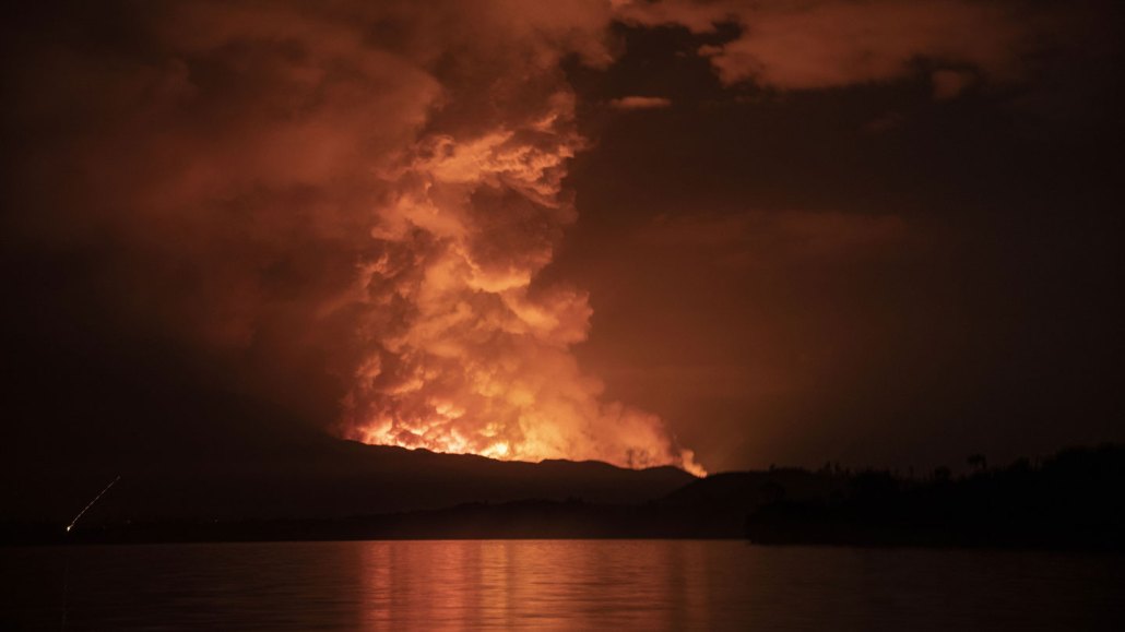
Without the usual seismic warnings, Congo’s Mount Nyiragongo burst suddenly into life on May 22, 2021. The volcano spewed lava and smoke that threatened the nearby city of Goma.
Alex Miles/AFP/getty images plus
- More than 2 years ago
In May 2021, Congo’s Mount Nyiragongo, one of the world’s most dangerous volcanoes, burst to life without warning. Lava erupted from fissures and flowed down the mountain toward cities below, leaving hundreds dead or missing and hundreds more injured.
Now, using data from monitoring stations installed near the volcano in 2015, researchers have pieced together how that eruption happened so suddenly. The data also suggest that the event could have been even deadlier — and highlight the urgent need to better understand this volcano’s particular hazards before the next eruption, volcanologist Delphine Smittarello and colleagues report in the Sept. 1 Nature.
“Nyiragongo is unique in that 1 million people are living just at the foot of the volcano,” says Smittarello, of the European Center for Geodynamics and Seismology in Luxembourg. The mountain sits near the eastern border of Congo, looming over both the Congolese city of Goma, population of about 700,000, and the Rwandan city of Gisenyi, population about 83,000 (SN: 12/2/14). “There are so many people so close to a very dangerous place.”
Nyiragongo’s last two eruptions, in 1977 and 2002, were both presaged by days of distinct seismic rumblings strong enough to be felt by people living nearby. But before the eruption on May 22, 2021, even the sensitive monitoring stations near the volcano seemed to detect no clear warning signs of magma on the move underground.
There was the large lake of molten lava burbling in the volcano’s summit crater: By 2021, that lake had risen to near the top of the crater. But typically lake level alone isn’t enough to indicate an imminent eruption, Smittarello says. Levels had intermittently risen and fallen over the years since 2002 as magma moved around the volcano’s deep plumbing. And in 2021, the lake was still 85 meters below its 2002 level.
So Smittarello and her colleagues took another look at the monitoring stations’ seismic and acoustic data. This time, the analysis identified a rumbling of small quakes that commenced just 40 minutes before the actual eruption. Half an hour later, just 10 minutes before the lava burst through, detections of acoustic signals — low-frequency “infrasound” waves — began to increase, a hint that the volcano was about to erupt (SN: 6/25/18).
The trigger for the actual eruption was probably a tiny rupture that formed in the volcanic cone due to the buildup of stress over time from the pressure and heat of the magma within, the researchers say. That would have been enough to allow the magma to push through.
The short lag time between the signals and the eruption was probably because that magma was already extremely close to the surface, the researchers suggest. “What we monitor is the magma moving, not the presence or absence of magma,” Smittarello says. Because the magma had very little distance to travel, there was also very little warning.
The eruption itself lasted about six hours, but in its aftermath, there was plenty of seismic activity lasting another 10 days, suggesting the magma was now on the move. Those data, monitored in real time, indicated something troubling — the magma was moving underground, away from the summit, snaking beneath the city of Goma and nearby Lake Kivu.
As the magma migrated, scientists and local citizens worked together to trace the formation of cracks in the ground, which can indicate propagating dikes, lateral pathways through which magma is moving beneath the surface. Similar lateral pathways formed during the eruption of Kilauea in Hawaii, Smittarello says. In that case, the magma migrated to a neighborhood along the volcano’s lower east rift zone before erupting (SN: 7/6/18).
Based on the possible path of the magma, Goma city officials issued evacuation orders for tens of thousands of people who were potentially in the magma’s path. Meanwhile, scientists anxiously watched for signs of a potential “limnic eruption” at Lake Kivu — a rare type of disaster in which a noxious cloud of dissolved gases like carbon dioxide and methane suddenly erupts from deep lakes, suffocating living creatures nearby (SN: 4/2/94). Gas-rich magma seeping into the lake’s bottom could have triggered such an eruption. In either case, “if [the magma] finds a path to the surface, it’s a catastrophe,” Smittarello says.
Neither catastrophe occurred, thankfully, Smittarello says. “It was a lucky situation. But we don’t know why.”
It was especially lucky given the fact that the magma was closer to the surface than thought at the time, the team reports in the new study. That means the residents above were even closer to greater disaster than had been realized.
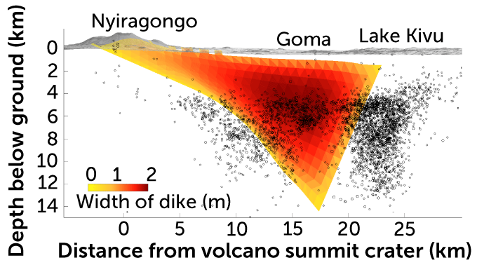
Reanalysis of posteruptive seismic data let the researchers determine the actual position of the underground dikes. The team found that one dike beneath Goma was as shallow as 450 meters deep. That’s particularly surprising because such a shallow magma channel would be expected to emit a telltale cocktail of volcanic gases from the ground cracks.
What lies beneath
In the aftermath of Congo’s Mount Nyiragongo eruption on May 22, 2021, seismic data (black circles) indicated that magma was moving underground away from the volcano’s summit and toward the city of Goma and Lake Kivu. In a new study, researchers used those data to map the extent and width of the dike (widest at the reddest color). To their surprise, they found that it was as shallow as just 450 meters beneath Goma at one point and presented a serious threat.
Dimensions of a volcanic dike

It’s not unheard-of for volcanic dikes to give no gassy indicators of their presence, says geophysicist Michael Poland of the U.S. Geological Survey, who is based in Vancouver, Wash., and leads the Yellowstone Volcano Observatory. The magma may have lost a lot of its gases as it circulated up into the summit lava lake; by the time it pushed into underground channels, it was potentially already degassed.
But that scenario is worrisome because there’s one fewer warning signal of possible danger to the communities above, says Poland, who was not involved in the new study. It also raises new questions — such as how such gas-poor magma might interact with Lake Kivu if it does flow into the lake.
What the 2021 eruption makes clear is that scientists need to investigate such questions to get a better understanding of the peculiarities of Nyiragongo — and to tailor monitoring and hazard warnings accordingly, Poland adds.
All volcanoes have their own personalities, and scientists need to develop a better appreciation for any warning signs that might exist. In this case, for example, that might include the lava lake level, he says. “The traditional approach is less reliable at Nyiragongo.”


