A new advanced weapon may offer strategy guidance for the war in Afghanistan: math. Using secret U.S. military logs made public by WikiLeaks, scientists have created a mathematical simulation that may help predict the intensity and whereabouts of future insurgent activity.
The simulation also evaluates its own predictions, acknowledging that some events may be impossible to foresee. Such an approach might help decision makers better weigh their options, the researchers say online July 16 in the Proceedings of the National Academy of Sciences.
“If the model says there’s a lot of uncertainty about what’s going to happen in an area, then you might act differently than if you were more certain that you were going to see an increase in activity,” says computer scientist Guido Sanguinetti of the University of Edinburgh, coauthor of the new study.
Sanguinetti and his colleagues took a mathematical approach that’s typically used by epidemiologists to predict the spread of a virus or disease outbreak. But instead of using data on the where and when of newly infected individuals, the researchers used details from the Afghan War Diary, a blow-by-blow of the conflict in Afghanistan that was published by the whistle-blower website WikiLeaks in 2010. The documents contain more than 75,000 logs of military actions, from routine searches to major gunfights.
Data fed to the computer simulation are represented as coordinates on a map, generating a good visual representation of how and where in Afghanistan the conflict escalated from 2004 through 2009. After training the model on the War Diary data, the team asked it to predict the likelihood and whereabouts of armed opposition group activity in 2010.
The program fared pretty well: In Baghlan province, for instance, the simulation predicted a 128 percent increase in armed opposition group activity from 2009 to 2010. The Afghanistan NGO Safety Office, a nonprofit group dedicated to protecting aid workers in dangerous parts of the world, reported that activity in Baghlan rose by 120 percent from 100 incidents in 2009 to 222 incidents in 2010. With additional data, the model may perform even better, Sanguinetti says.
The model also estimates the probability that its predictions are correct, illuminating areas where it’s really hard to predict future activity.
“It delivers best guesses with honest estimates of how good those guesses are so you don’t have to be dogmatic,” says statistical epidemiologist Peter Diggle of Lancaster University and the University of Liverpool, both in England. “This is a very nice and imaginative application of this modeling approach. It’s a good piece of work.”
Such simulations nicely complement approaches that look at the social dynamics of a conflict and the demographics and history of the people involved, says John O’Loughlin, an expert in the geography of conflict at the University of Colorado Boulder. While the predictions are at the province level and not very fine-grained, they are still informative, he says, especially given how wars are fought today. “During the Cold War it was tit-for-tat modeling at the international level,” he says. “Almost all wars are irregular these days. It’s not armies lining up against each other with front lines.”
Back Story | Putting wikileaks on the map
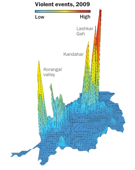 J. O’Loughlin et al/Eurasian Geography and Economics 2010
While the secret U.S. military logs released by WikiLeaks in 2010 contain little in the way of intelligence, the data are still revealing, says political geographer John O’Loughlin of the University of Colorado Boulder. Three-dimensional mapping of more than 46,000 violent events recorded in the leaked documents, for example, shows a hefty uptick in violence after 2006 that increases dramatically in 2009 (pictured, as viewed from the north). The fine-grained analysis by O’Loughlin and colleagues, published in 2010 in Eurasian Geography and Economics, pinpoints the cities of Kandahar and Lashkar Gah as growing hotbeds of violence, along with the Korangal Valley (known to American troops as “The Valley of Death”). Their analysis also reveals the spread of insurgency violence over time. Until mid-2009, about 46 percent of violent events took place within 100 kilometers of the border with Pakistan, an important refuge for insurgents. The violence then creeps beyond that buffer zone, illustrating the diffusion of insurgents beyond standard Taliban strongholds.