Three rivers now interred beneath heaps of sand in the Sahara Desert might have been the superhighways of the Stone Age.
Simulations reveal that the rivers, each about as big as the Missouri or Rhine River, meandered across the Sahara 125,000 years ago. Early humans probably followed the lush corridors as migration routes across North Africa, scientists propose September 11 in PLOS ONE.
Satellite data and other geologic evidence had previously suggested that now-extinct rivers once snaked across the Sahara. But the records couldn’t say when and how much water flowed, says Jennifer Smith, a geologist at Washington University in St. Louis. The simulation, she says, “gives us a much clearer picture of these landscapes.”
The ancient rivers existed when the winds of the African monsoon were up to 1,000 kilometers farther north than today and brought seasonal rain to mountains in the central Sahara. The rain ran down the peaks and flowed north toward the Mediterranean Sea.
Although the Sahara was wetter, much of it was still semiarid, says study coauthor Tom Coulthard, a hydrologist at the University of Hull in England. “We were quite pessimistic about whether there was enough water to make it across the desert.”
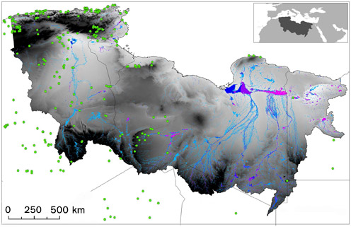
But that’s just what Coulthard and colleagues found. The team simulated how much rain fell on mountains in southern Algeria, southern Libya and northern Chad over a 25-year period roughly 125,000 years ago. They then used topographic maps to see how rainwater flowed across 12 million square kilometers of North Africa.
Their findings indicate that two rivers were perennially present in parts of eastern Libya, northern Chad and western Egypt while a third, seasonal river was 2,000 kilometers to the west in Algeria. In addition, more than 70,000 square kilometers of lagoons and wetlands covered northeastern Libya. The team didn’t simulate runoff to the Nile, but that river probably would have been around too, Coulthard says.
Plants and animals living around the rivers probably drew early humans to these waterways. The western river may have been a preferred route, the researchers speculate. The river connected a humid, mountainous area in the south with a wet, temperate region along the Mediterranean coast. Dozens of archaeological sites dating to around this time pepper the western region; only a few have been found near the eastern rivers.
The lack of archaeological sites in the east may simply reflect a preservation bias or a preference in where researchers have looked, says Michael Petraglia, an archaeologist at Oxford who wasn’t part of the study.
Chris Stringer, an anthropologist at the Natural History Museum in London, suggests a similar simulation of African rivers 100,000 years ago could help researchers understand how unique human behaviors, such as bead-making and pigment use, spread across Africa around this time.