Evolution of river systems

RUNNING WATERS When a value called χ varies across watershed boundaries, as it does along the crest of the Blue Ridge Mountains (thick white line), the river networks are still evolving and the ridge is shifting, a new study shows.
S.D. Willett et al/Science 2014, Courtesy of Science/AAAS
A river’s erosion downward and across a landscape is based on a variety of factors, including terrain steepness and the arrangement of tributaries.
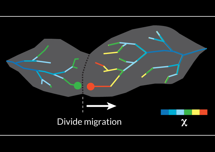
If values on either side of a watershed boundary (white lines) are similar, the ridge that divides the neighboring networks is probably stable. But if the values differ substantially, as they do across watershed boundaries along the crest of the Blue Ridge Mountains (thick white line), that’s a sign that the river networks are still evolving and that the ridge is shifting. The divide along the Blue Ridge Mountains has been migrating inland since rifting first formed the Atlantic Ocean more than 200 million years ago, the researchers note.

This simulation depicts evolving terrain in a 100-kilometer-by-50-kilometer region, as seen from above, over the course of 160 million years. At the start, the mountainous landscape at the upper edge of the region has been rising steadily at a rate of 5 millimeters per year, and terrain at the lower edge was rising a only one-tenth that rate. The video begins with a shift in uplift rate to 1 millimeter per year across the landscape, which triggers an equally abrupt shift in erosion patterns. Over time, river networks draining from the mountain range reach a new equilibrium, with drainage divides moving toward sites where χ is large.
Source: S.D. Willett et al/Science 2014, Courtesy of Science/AAAS


