In spring 2010, the military plans to embark on a road trip across the country to test a new way of navigating. Instead of taking a path marked by a dog-eared road atlas, a compass, or even global positioning satellites, the vehicle will follow one mapped by supercold cesium atoms.

This cross-country trek will be a field test for the Defense Department’s Precision Inertial Navigation Systems program to navigate by measuring the Earth’s rotation using atoms that behave like waves. The vehicle won’t drive blind, but the machine guiding it could make such a feat possible. And someday the new system could also improve the accuracy of gyroscope navigation in airplanes 200-fold, says Air Force Lt. Col. Jay Lowell, who is leading the project.
The atoms’ direction-finding powers come from a technique called atom interferometry. Once a lab curiosity, atom interferometry is now becoming the Swiss Army knife of physics. It has the potential to steer airplanes and submarines, uncover buried caches of oil and diamonds, and perhaps hunt down cave-dwelling terrorists. The technology is also helping scientists probe the very nature of the universe, from detecting theoretical waves of gravity sent out by exploding stars to measuring deviations in the strength of gravity at superclose distances. Physicists are even rallying to put an atom interferometer in orbit to test theories like Einstein’s general relativity with unparalleled exactness.
“In the last 10 years, atom interferometry has gone from inventions and demonstrations into precision measurement tools,” says physicist Alex Cronin, an expert on the technique at the University of Arizona in Tucson.
The path less traveled
At its heart, atom interferometry is similar to light interferometry, a 200-year-old technique that itself improved the accuracy of many measurements.
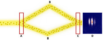
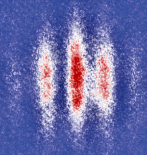
Shine a light through a half-silvered glass plate and half the waves pass through, while half bounce off at an angle. A couple of regular mirrors can reflect the two beams back together. If one wave travels a little bit further than the other, the recombined waves will be slightly out of sync. With visible light, this effect produces a pattern of white-and-black stripes: white stripes correspond to areas where the waves line up and black stripes to where they cancel each other out. Physicists use this effect—called an interference pattern—to calculate differences in the distance each beam travels.
During the late 1800s, two American physicists, Albert Michelson and Edward Morley, used a light interferometer to try to detect the “luminiferous ether,” then thought to occupy all space. Just as sound consists of vibrations in air, light was supposedly a vibration of the ether, scientists thought. If so, the apparent direction of Earth’s motion through the ether would alter the velocities of light beams taking different paths. However, Michelson and Morley’s experiment found no such difference, casting doubt on the ether’s existence.
Classical physics explains the interference of light waves just fine. Atom interferometry, however, hinges on the bizarre behavior of atoms predicted by quantum mechanics, the math that describes how matter works at sub-microscopic scales. Just as waves of light can sometimes act like particles called photons, atoms can be coaxed into showing off their inner waves. In this condition, an atom can exist in two or more places at once, called a superposition. “It’s just weird and you finally end up saying this is a very weird theory,” says physicist David Pritchard, a pioneer in the field who works at the Massachusetts Institute of Technology.
One advantage of using atoms for interferometry is their tiny wavelengths. In the 1920s, French physicist Louis-Victor de Broglie proposed that a particle could behave as a wave, and the wavelength would be determined by the particle’s speed and mass; the heavier and faster the particle, the shorter its wavelength. Shortly thereafter, experiments proved de Broglie right. The atoms used in interferometry have wavelengths around a hundredth of a nanometer, while the wavelength of visible light measures from 400 to 700 nanometers. Atom waves split into two paths can be used to detect much smaller differences than light. If the path an atom takes varies by even a thousandth of a nanometer (a picometer) an atom interferometer can spot the difference, Cronin says.
Another benefit of atoms is the breadth of their physical characteristics, which include mass, magnetic sensitivity, and ability to hold an electric charge. And atoms feel the pull of gravity. If light interferometry is an old wooden meter stick, then atom interferometry is a modern tape measure, scale, and voltmeter rolled into one.
Yet these beneficial traits also make atoms tough to observe as waves, Cronin says. Atoms flitting about at room temperature tend to bump into one another. To better detect the waves, physicists cool the atoms to a few millionths of a degree above absolute zero—the temperature at which all atomic motion virtually stops—and manipulate them to fly in the same direction.
Hitting pay dirt
The first atom interferometers were developed in the early 1990s by four independent teams working in Germany and the United States. Initial applications, such as exacting measurements of the Earth’s gravity and rotation, were obvious, says Pritchard, whose MIT lab developed one of the first atom interferometers. “When we made it, we certainly had a pretty good list of things we wanted to do,” he says. “What I think was a little surprising to me was the rapidity with which the precision developed.”
Many researchers, including Pritchard, credit Mark Kasevich, a Stanford University physicist, with pushing the frontiers of atom interferometry, especially its more practical uses. “Mark’s a very good scientist, but he’s an off-the-scale good engineer,” Pritchard says.
Kasevich’s lab is using an atom interferometer to sense tiny fluctuations in the Earth’s gravity. High school physics students learn that every second an object is in free fall, it speeds up another 9.8 meters per second. This isn’t exactly true, says Kasevich. The acceleration from gravity gets smaller the further you are from the Earth’s center. The difference in gravity—the gravity gradient—between sea level and the top of Mount Everest is about 0.3 percent.
On the Earth’s surface, gravity’s acceleration changes depending on the composition of the rock (or other substance) beneath it. “Anytime you have missing dirt, you can ask if you can find the gravity gradient,” Kasevich says. It’s a task perfect for an atom interferometer. “One of the killer applications is using it to find oil and minerals,” he says.
One hundred thousand metric tonnes of oil buried a kilometer underground will decrease the effect of gravity by a few hundred thousandths of a percent compared with the surrounding rock—small enough for an atom interferometer to detect. The international mining company BHP Billiton has used conventional gravity gradiometry to hunt for diamonds in Australia and Canada’s Northwest Territories. Atom interferometry could make these searches even more accurate, Kasevich says.
Oil reserves and diamond caches aren’t the only buried structures that atom interferometers could find, says Lowell, program manager for atom interferometry applications at the Defense Advanced Research Projects Agency (DARPA), an arm of the military that supports speculative research. DARPA will fund about $5 million in atom interferometry work this year, Lowell says.
Underground bunkers or even caves might someday be detected with an atom interferometer.
Better navigation may be the most immediate commercial application for atom interferometry. GPS can’t reach every nook and cranny of the Earth—deep underwater, for instance—and planes need to have a way of navigating that doesn’t count on spotty satellite signals. Today, most jumbo jets have navigation systems that measure the change in the Earth’s rotation relative to a fixed point. But these gyroscopes lose about 1 kilometer of accuracy every hour. The military’s atom interferometry system aims to cut the loss to 5 m every hour, Lowell says. The cross-country road trip planned for 2010 will test this accuracy by comparing the measurements of an onboard atom interferometer to known landmarks.
Such precision has become routine in lab experiments, but building an interferometer that can take the bumps of an airplane or helicopter ride demands changes to lab models, Lowell says. “We have systems that are now smaller and more compact and work with the flip of a switch, instead of a system that takes up massive chunks of tabletops and a rack of equipment, and takes armies of grad students to keep operating,” he says.
A constant struggle
On a sprawling 20-by-20-foot table at the National Institute of Standards and Technology (NIST) in Gaithersburg, Md., physicist Kris Helmerson shows off an instrument that does in fact demand an army of graduate students.
On one end of the gigantic table, the eerie glow of an orange laser dances around a dozen little lenses and mirrors set at different angles and orientations. The laser will chill sodium atoms to a hair above absolute zero. In this state, hundreds of thousands of atoms together act like one big wave, called a Bose-Einstein condensate.
Just creating the condensate earned Nobel prizes in 2001 for the three physicists who accomplished the feat in 1995. Helmerson, who works in NIST’s Advanced Measurement Laboratory, uses atom interferometry to measure more esoteric properties of Bose-Einstein condensates. In 2000, for instance, he and colleague Bill Phillips put a kind of sound wave, called a soliton, into their condensate. And in 2006, the team created a whirlpool-like vortex out of a condensate.
Less exotic pursuits keep other atom interferometers busy. The most common experiments are measurements of physical constants, the numbers describing gravity, electricity, and other forces that make the universe tick. Over the past two centuries, light interferometry refined these figures, and atom measurements will do the same, says physicist Steven Chu, director of the Lawrence Berkeley National Laboratory in California.
Chu, whose lab is based at Stanford, has shown that atom interferometry can achieve the same precision as conventional methods in measuring the acceleration due to gravity on Earth. With technological improvements, atom interferometry could do even better.
Atom interferometry could also refine another measure of gravity—the constant that describes the gravitational tug between any two objects, which physicists call “big G.” Currently, G’s value is known only to one part in 10,000. That’s equivalent to knowing the length of 100 meters (roughly a football field) down to a centimeter—not very precise by the usual standards for fundamental constants of nature. “It’s kind of embarrassing,” Cronin says.
In a paper in the Feb. 8 Physical Review Letters, a team of Italian physicists suggests that atom interferometry could improve the precision of G by at least a factor of 10. In another paper, the same team used atom interferometry to measure gravity between objects separated by a few millionths of a meter. Such measurements could reveal a breakdown in Newton’s laws of gravity, which could have implications for theories suggesting the existence of extra dimensions of space.
Adding an extra digit or two to constants like G may sound like the scientific equivalent of dotting i’s and crossing t’s, but physicists like Chu think otherwise. “It’s not chasing after the last digits,” he says. “It’s chasing after the first digit of something radically new.” Better telescope measurements of celestial orbits buttressed Newton’s theory of gravity, and Einstein’s theory of special relativity explained the results of Michelson and Morley’s light experiments. Likewise, atom interferometry could augur the next scientific revolution, Chu says. “Whenever you make something orders of magnitude better and extend your ability to see, you’re going to stumble onto something new.”
Colliding frontiers
A basement physics laboratory at Stanford might produce such a discovery. Kasevich’s team is nearly finished building the world’s biggest atom interferometer, a 10 m deep well. Several factors determine an interferometer’s precision, but the distance the atoms can travel is a big part of it. The first experiments planned for the device include testing whether objects of different mass fall at the same rate, echoing Galileo’s legendary experiment at the leaning tower of Pisa. Kasevich plans to toss two different kinds of rubidium atoms down his interferometer. The atoms differ slightly in mass because one contains more neutrons than the other.
Even with his giant interferometer set to begin experiments in 6 months, Kasevich is thinking bigger. A planned underground laboratory in the abandoned Homestake gold mine in Lead, S.D., has the physicist licking his lips. “We’ve been brainstorming about what we can do if we have a kilometer rather than 10 meters,” he says.
Yet all interferometers on Earth, however deep, suffer from environmental noise, such as ocean tides and earthquakes. Physicists go to great extremes to shield their instruments from these effects, but as precision increases, environmental noise eventually drowns out results. “For the ultimate in precision we would like to consider space,” says Savas Dimopoulos, a theoretical physicist at Stanford who hopes to use atom interferometry to detect gravitational waves radiating from pairs of black holes and other binary systems. He’s working with Kasevich to perform the experiments on Earth, but a space experiment offers an even better chance to see the gravitational waves, which could provide a glimpse of the early universe. Any launch is at least a decade away, Dimopoulos says.
While atom interferometry probes the universe with growing meticulousness, another frontier of physics is taking a different approach to unlocking its secrets. Deep below ground crossing Switzerland’s border with France, an army of physicists and engineers is readying the world’s largest particle accelerator, the Large Hadron Collider (LHC), for a planned summer startup. With the LHC, physicists will smash protons together at speeds within a sliver of the speed of light, hoping to find new forms of matter.
These two approaches—precision and high energy—overlap in the questions they can answer, Dimopoulos says. For instance, the LHC could detect what are called supersymmetric particles—sparticles—that he and other physicists have proposed lurk beside the quarks, neutrinos, and other elementary particles that fill the universe. Atom interferometry, by measuring the charge on an atom’s electrons with great sensitivity, could support the existence of those supersymmetric particles. “In the end we are looking for a new theory,” he says. “This one theory has the same consequences at high energy and high precision.”


