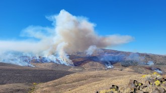
On November 29, Mauna Loa was spewing lava from a fissure on its northeast flank. Fountains from this fissure were up to 25 meters tall.
M. Patrick/USGS
Mauna Loa, Earth’s largest active volcano, abruptly woke up on November 27 after an almost 40-year nap. The volcano shot fountains of lava as high as 50 meters into the air, while rivers of molten rock streamed down the volcano’s flanks toward Saddle Road, the main highway on Hawaii’s Big Island.
Mauna Loa stands shoulder to shoulder with four other volcanoes, including explosively dramatic Kilauea (SN: 7/16/18) and quietly grumbling Mauna Kea (SN: 5/14/20). Kilauea has grabbed headlines in recent years with its pyrotechnics while Mauna Loa has slumbered. But the sleeping giant hasn’t been so quiet in the past, says Ingrid Johanson, a geophysicist at the U.S. Geological Survey’s Hawaiian Volcano Observatory in Hilo.
Historically, she says, Mauna Loa would awaken every seven years or so on average. This last stretch between eruptions “is quite a big gap.”
Science News talked with Johanson about how Mauna Loa tends to wake up, what’s in the path of the lava and what sort of neighbors Kilauea and Mauna Loa are.
Were there warning signs that Mauna Loa was about to erupt?
“It depends on what you mean by warning,” Johanson says. “In a manner of speaking, we’ve known that Mauna Loa was showing signs of unrest since 2015.” At that time, she says, there was an uptick in the rate of local earthquakes, as well as in GPS observations of land deformation — a bulging upward of the land surface that indicates magma is on the move below ground.
Those signs tapered off a bit and then increased again over the last six months, suggesting “that the situation was evolving,” Johanson says. But when the volcano would actually erupt wasn’t possible to determine. “Fundamentally, we had about an hour and a half of warning,” she says. That was the time span between when researchers noted a sudden swarm of earthquakes pointing to an imminent eruption and the emergence of lava.
That short notice is “true to form” for Mauna Loa, she adds. Its “other eruptions have evolved very quickly in the same way.”
How is the monitoring of Mauna Loa different than it was before the last eruption in 1984?
“One of the big differences between 1984 and now is the technology,” Johanson says.
“We can see more earthquakes [and] detect a wider range of frequencies in the seismic waves. And we have GPS and electronic tiltmeters to measure deformation continuously.” That technology allowed scientists to detect not only that there was land deformation recently, but also how it was changing over time, giving just a bit of extra warning time.
That wasn’t possible 40 years ago. Back then, researchers measured deformation by hand, hiking up to the volcano’s summit every few weeks or so. “There was a technique called EDM, for electronic distance measuring, which was essentially shining a laser into a reflector, so you could get very precise distance measurements,” Johanson says. Subtle shifts in the reflector’s location, installed on the volcano, helped reveal the deformation.
Does the current eruption pose a threat to people?
“It’s a little early to tell — it’s not yet clear how much volume we can expect out of this eruption,” Johanson says. “I don’t think it’s a given that this will be a more momentous eruption than past ones, but there is a sense of maybe coming back to business as usual for the volcano.”

The good news is that the lava flows don’t currently pose a threat to communities on the Big Island. However, Saddle Road connects the island’s eastern and western sides, Johanson notes. “If the lava were to cross the highway, it would really impact the island.”
But the eruption has interrupted data collection for one of climate science’s most iconic charts: the Keeling Curve, a nearly unbroken 60-year record of atmospheric carbon dioxide that shows a steady rise in levels of the gas.
The carbon dioxide data are collected from instruments at the Mauna Loa Observatory. The eruption cut off power to the observatory on November 28. As of November 30, the power had not yet been restored, and lava flows had cut off access to the site. For now, it’s unclear if the interruption will have a lasting impact on data collection.
Kilauea has been erupting more or less continuously for decades. How are Kilauea and Mauna Loa connected?
They are two separate volcanoes with geochemically distinct lavas, suggesting their plumbing systems — the networks of tunnels and channels through which magma moves — are separate. That plumbing separation probably occurs below the crust and in the mantle, Johanson says, though ultimately the volcanoes tap into the same mantle hot spot (SN: 1/6/22).
That said, Kilauea and Mauna Loa are uneasy neighbors, communicating through changes in pressure and stress underground, she says. Pressure changes in the plumbing beneath one volcano can subtly affect the other, for example, altering how easy it is for one volcano to expand, making way for more magma to move in. “They do kind of elbow each other a little bit.”