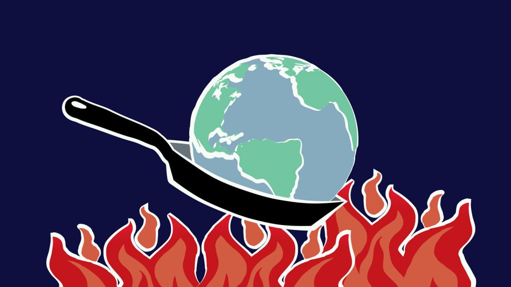
El Niño and climate change combined are shattering global temperature records, pushing Earth into uncharted territory.
MHJ/DigitalVision Vectors/Getty Images Plus
Global temperatures are shattering records as El Niño and climate change compound.
On July 3, the planet sweltered as the average global temperature reached 17.01° Celsius (62.62° Fahrenheit), the highest ever recorded, according to data from the U.S. National Centers for Environmental Prediction. That surpassed the previous record of 16.92° C (62.46° F) from August 2016.
By the end of the week, that new record was tied or broken three more times, peaking on July 6 at 17.23° C (63.01° F). And Earth just experienced its hottest June ever recorded.
This time of year is usually when the average global temperature peaks. But the extraordinary nature of this year’s June and July probably stems from what’s going on in the big blue. Oceans around the world have grown alarmingly warm, thanks in no small part to human-caused climate change, researchers say. And El Niño, the recurring climate pattern known to temporarily heat the planet, has finally returned.
“We’ve really never had this set of circumstances before,” says atmospheric scientist Jennifer Francis of the Woodwell Climate Research Center in Falmouth, Mass. “We’re entering uncharted territory.”
Hot oceans are a problem
Much of the extreme heat we’re seeing goes back to the state of our oceans, says climate scientist Thomas Di Liberto of the U.S. National Oceanic and Atmospheric Administration in Washington, D.C. “The global ocean has just been so, so warm.”
Our planet’s seas have been warming for decades. The most recent decade has been the sea surface’s hottest since at least the 1800s. In April, the average surface temperature of the world’s oceans reached 21.1° C, the highest ever recorded.
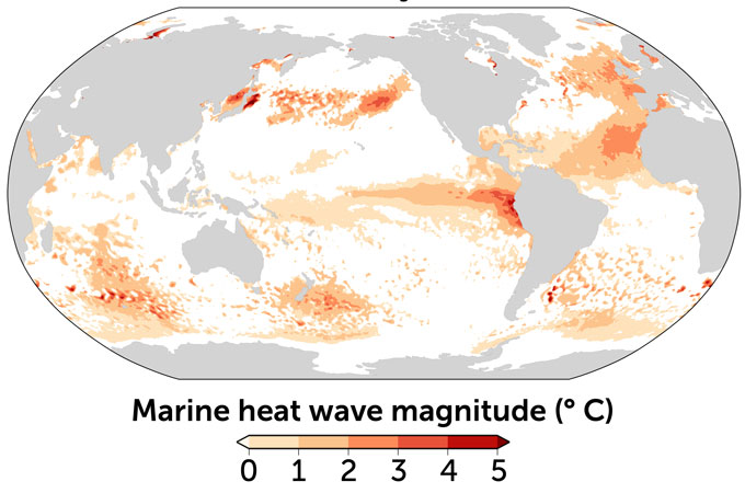
It’s been particularly warm in the North Atlantic, where records are being broken by large margins. In April, sea surface temperatures there surpassed 4 degrees C above what’s normal for that time of year (SN: 6/15/23). And in the Gulf of Mexico, the average surface temperature is more than 30° C, as of July 12, the highest recorded for this time of year since satellites began monitoring there in 1981. Both are examples of marine heat waves, persistent periods of anomalously warm ocean temperatures.
Such heat waves currently plague about 40 percent of the world’s oceans. NOAA forecasts suggest that by September, marine heat waves could prevail across half the global ocean, Di Liberto says. These extreme events have become about 50 percent more common over the last decade. Much of that warming has to do with climate change, he says. “We’ve juiced the system.”
Hotter seas are a huge problem, says atmospheric scientist Marybeth Arcodia of Colorado State University in Fort Collins.
“The ocean is currently taking [in] about 93 percent of the heat associated with global warming,” Arcodia says. As the oceans warm, they become less capable of absorbing heat from the atmosphere, so that’s where it remains, raising the global temperature.
El Niño has arrived
Operating on top of this background of ocean warming is a natural climate cycle called the El Niño-Southern Oscillation, or ENSO. The phenomenon entails yearslong fluctuations in sea surface temperatures in the central and eastern tropical Pacific Ocean. These water temperature changes are controlled by equatorial air currents known as the trade winds.
During neutral ENSO conditions, the trade winds blow westward against the surface of the Pacific Ocean, pushing warm water toward Indonesia and triggering the upwelling of cold water from the ocean’s depths along the South American coast. When the trade winds blow especially strong, more warm water is pushed east. This part of the cycle is called La Niña. In March, the Earth exited three years of La Niña conditions, a relatively long-lived phase.
Then in June, La Niña’s counterpart, El Niño, got underway. Many scientists think that El Niño can be triggered by westerly wind bursts — anomalous winds that sometimes appear in the western Pacific, says physical oceanographer Regina Rodrigues of the Federal University of Santa Catarina in Florianópolis, Brazil. These bursts blow opposite to the trade winds and weaken them, she says, setting the stage for El Niño.
Unbidden by the westbound winds, warm water in the western Pacific sloshes back toward the Americas. Ocean upwelling along the tropical South American coast is stifled, and much of the tropical Pacific — which at the equator wraps halfway around the planet — becomes swaddled in a warm duvet of water, which can be hundreds of meters deep. That balmy layer exudes heat into the atmosphere, where much of it is trapped by the greenhouse gases that humans have emitted, raising the global temperature.
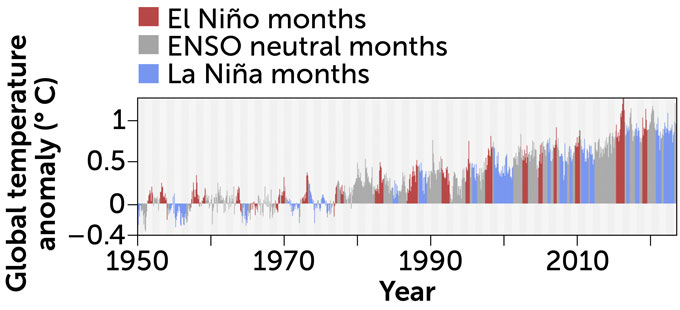
El Niño is typically associated with warmer global temperatures, while La Niña is often correlated with cooler temperatures, Arcodia says. “2016 is currently the hottest year on record,” she says. “That lines up with the strongest El Niño event on record.”
But El Niño and La Niña don’t always have predictable outcomes. For instance, 2020 was the second hottest year on record, and it was during La Niña conditions, Arcodia says. That underscores the influence of climate warming on these record-breaking temperatures, she says.
While it’s probably safe to say that El Niño is exacerbating climate warming, it’s hard to say exactly how much the phenomenon’s return contributed to the recent unprecedented heat, Di Liberto, Rodrigues and Arcodia agree.
We’re just getting started
This El Niño is still in its infancy. The climate pattern typically peaks during the Northern Hemisphere’s winter, so Earth has probably not yet felt the full brunt of the impact. That means the planet may be in store for even higher global temperatures later in July, Di Liberto says. Even later in the year, Earth will probably see more anomalously warm months as El Niño continues to strengthen.
Since the climate pattern hasn’t reached full force, it’s hard to draw comparisons with its past manifestations. But forecast models do suggest that there is a better than 50 percent chance of this El Niño developing into a relatively strong one, Arcodia says. In such a scenario, the average temperature of the east-central tropical Pacific would temporarily reach or exceed 1.5 degrees C above normal. In early June, temperatures in that part of the Pacific were already 0.7 degrees C above normal.
It’s possible that the relatively long La Niña period we just exited might have set the stage for a strong El Niño, Rodrigues speculates. That La Niña spent three years packing the western Pacific with warm water, loading it like a spring, she says. Now, that spring has been released.
With El Niño exacerbating things, this year could become the hottest year on record. There’s about a 13 percent chance that 2023 takes the title, and a nearly 90 percent chance that it’s among the top five on record, according to the U.S. National Centers for Environmental Information.
What’s more, some scientists are concerned that the El Niño could temporarily push global warming more than 1.5 degrees C above preindustrial levels for the first time, Rodrigues says.
Many experts have warned that crossing that benchmark could trigger irreversible changes in some parts of the planet (SN: 10/7/18). That could include the transformation of the Amazon rainforest and more widespread melting of the Greenland and Antarctic ice sheets (SN: 6/16/23; SN: 11/9/22; SN: 2/15/23). But because El Niño is a temporary phenomenon, it’s hard to say if, or how, the climate pattern might impact these elements, Rodrigues says.
It’s a momentous experiment, she says. One with us, and the rest of life on Earth, stuck in the middle.
