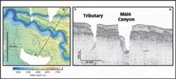
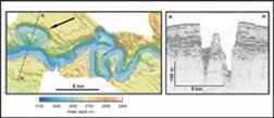
In April 2003, scientists on the German research vessel Meteor were cruising toward a site off the arid northwestern coast of Africa. On a mission to examine the erosion that sculpts the ocean floor, the crew was anxious to reach the study site to focus the ship’s seafloor-scanning sonar on an area where they knew undersea landslides had occurred. It’s a good thing they turned their equipment on early. At least 150 kilometers short of their destination, the sonar revealed a previously unknown undersea canyon deep enough to swallow an 85-story skyscraper.


Later in the expedition, after surveying the landslide area, the researchers returned to map the 2.5-km-wide gash, says Russell B. Wynn of the University of Southampton in England. First, they followed the canyon toward the coast, then they zigzagged across it at several spots to record its profile. In all, the investigators charted more than 200 km of the canyon’s path.
The newly discovered canyon system—which the researchers named Cap Timiris Canyon, after a nearby cape on the African coast—looks like a river valley, only it’s on the bottom of the sea. Finding the canyon was a surprise because a submarine feature of that size had never previously been reported off the coast of a desert area, says Wynn.
Just as surprising: Sediment cores drilled from the bottom of the canyon contain thick layers of sand, hints that the channel is still being carved out. The sculptors would be turbidity currents—intermittent, gravity-driven flows of turbulent water that carry silt, sand, and gravel, much as an alpine avalanche carries snow, rocks, and skiers.
Researchers are studying undersea canyons with a variety of tools. Scientific instruments deployed off southern California have recorded the frequency and the violence of turbidity currents and provide hints as to what triggers them. Recent analyses of the seafloor topography off the coast of Virginia suggest that these currents also play a large and widespread role in carving and sculpting riverlike networks of undersea canyons there.
Undersea canyons are some of Earth’s unsung geological masterpieces. Sometimes almost as long as their terrestrial cousin the Grand Canyon, they act as conduits for vast volumes of sediment washed from the continents. When those languid flows of silt—often enriched with organic material—reach the ocean deeps, they settle out in thick, fan-shaped formations. Carbon compounds in the sediments are a source of food for organisms that dwell in the seafloor’s ooze today and collectively serve as feedstock for the formation of petroleum.
Slip ‘n’ slide
Scientists haven’t often caught turbidity currents on the move. However, researchers a few years ago came closer than they knew.
On April 1, 2002, a team sent a remotely operated vehicle into Monterey Canyon, an underwater feature off the California coast, to recover some scientific instruments that the scientists had placed there the previous December. They quickly discovered that things weren’t as they’d left them.
Considering the equipment’s remote setting—about 20 km offshore and in the canyon’s main channel at a depth of about 525 meters—the changes probably weren’t part of an April Fools’ Day prank.
One instrument, which sends out signals that enable researchers to locate and retrieve it was eventually found about 110 m down-canyon from where it had been originally placed, says Charlie K. Paull of the Monterey Bay Aquarium Research Institute in Moss Landing, Calif. Weak signals from another device, which had been attached to an instrument deployed nearby to measure seafloor currents, led the scientists to a point another 400 m or so down the submarine valley.
There, sensors indicated that the vehicle was just a few meters from the missing device. Onboard cameras scanned in all directions but, despite clear conditions, couldn’t spot it. That’s when the researchers realized that it had been buried beneath the canyon floor. Two days later, excavations discovered the instrument within a 70-centimeter-thick layer of material.
Data collected by pressure sensors on the device suggested that it had been swept 550 m down the canyon’s channel and buried at its new location during a journey lasting less than 10 minutes. Remarkably, a sediment-laden turbidity current had surged over the instrument less than 5 hours after it had been deployed, says Paull.
Another instrument about 10 km up-canyon from this site had also been swept away at the same time.
As part of another long-term study of sediments within Monterey Canyon, a separate group of scientists took samples at a depth of 1,297 m on Feb. 20, 2002, which was after the slide had occurred but before the instruments had been recovered. The topmost 40 cm of these cores consisted of mud that contained a thin layer of fresh chlorophyll, a sign that the mud had been in place no more than a few weeks, says Paull. The researchers recognized it as a sign of a recent debris flow but didn’t realize the current’s full extent.
Sediment samples collected later at a canyon depth of about 288 m, where another instrument had been swept away on Dec. 20, 2001, contained a fresh deposit of sand and gravel at least 1.25 m thick. Together, the sediment core and instrument data suggested that the roiling current occurred along at least 30 km of the 100-km-long canyon.
If the turbidity current deposited 70 cm or more of material along that length of the canyon, it probably carried a total of about 2.2 million cubic meters of sediment, says Paull. That seems to be the characteristic size for the canyon. Since early 2002, instruments in the canyon have detected five more debris flows of about that size but none larger.
More than a decade ago, scientists estimated that about 400,000 m3 of beach sand gets swept into the upper reaches of Monterey Canyon each year by currents that run along the shore. “When I first heard that estimate, I thought it was too big,” Paull says. “Now, I think it may be way too small.”
At first, sand and other material build up in the head of the canyon. When the pile becomes so steep that it’s unstable, the material suddenly breaks free in an undersea landslide that quickly billows into a turbulent, scouring flow.
More than 600 km south of Monterey Canyon, violent turbidity currents also frequently rip through Scripps Canyon off San Diego, says Douglas Inman of Scripps Institution of Oceanography. That canyon, like the one off Monterey, has a hearty appetite for beach sand—it swallows an estimated 200,000 m3 each year.
Because the scouring, sand-filled flows reach only partway up the canyon walls, Scripps Canyon in many spots is slightly wider at its base than it is several meters off the bottom. In cross-section, the lowest few meters of the canyon look like the bottom of an hourglass, says Inman.
Tubeworms, clams, and other organisms that anchor themselves to rocks aren’t found on the canyon’s lower walls, another indication that turbidity currents sweep through every year or so, says Inman.
Far out
The location of the head of an undersea canyon often determines how frequently its turbidity flows occur. The uppermost portion of Monterey Canyon, which underlies water that Paull can see from his office window, reaches to within 30 m of the shoreline. That’s not unusual for canyons along a tectonically active coastline, such as California’s.
However, along North America’s eastern coast, where continental shelves typically are wide and have gentle slopes, the heads of undersea canyons usually lie many kilometers offshore. Therefore, those canyons don’t capture much of the beach sand or sediment carried in coastline currents. Most of the sediments washed to the sea by rivers along the Atlantic Coast get trapped in large estuaries such as the Chesapeake Bay, says Christopher K. Sommerfield of the University of Delaware in Lewes.
Much of the material reaching offshore canyons of the Atlantic Coast today comes from the slow rain of plankton that die at the ocean surface. Most of the rest is fine-grained sediment that’s been repeatedly lofted from the ocean floor by ocean currents to hopscotch its way to the canyon-frayed fringes of the continental shelf.
Although supplied with less sediment than their California cousins are, East Coast canyons can show signs of activity too. Consider Hendrickson Canyon, off southern New Jersey. A field study in 1999 found a layer of sediment only a couple of centimeters thick, says Cecilia McHugh of Queens College in New York. That suggests that a geologically recent canyon-scouring turbidity current had passed through, depleting the chasm of material that previously had accumulated, she notes.
In contrast, the nearby Hudson Canyon has areas that are coated with up to 10 m of mud, an indication that only routine deposition of silt has occurred there in recent times. Even so, the canyon’s head, which lies about 250 km offshore at a depth of around 90 m, may have been much more active during the last ice age than it is today, says McHugh.
Last August at the 32nd International Geological Congress in Florence, McHugh and her coworkers described the remnants of an ancient, now-submerged shoreline that they discovered near the uppermost portions of the canyon at an ocean depth of about 125 m. They discerned the defunct shoreline’s coastal dunes on sonar maps of the ocean bottom. When they carbon-dated shells that lived in that old tidal zone, they determined that the shoreline was active about 17,500 years ago.
During the height of the last ice age, therefore, when sea level was at its lowest, it appears that the Hudson River probably was dumping sediments directly into Hudson Canyon’s uppermost portions, which lay on shore. The feature probably also swallowed large amounts of beach sand and sediments, just as Monterey and Scripps Canyons do today.
Down a notch
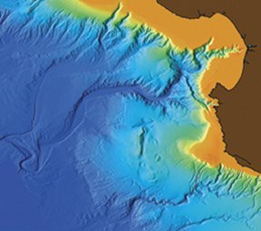
Hudson Canyon, one of the largest canyons on the Atlantic’s continental shelf, stretches about 500 km from shore. However, the entire edge of the shelf is serrated with networks of canyons that measure just several kilometers in length.
The networks share many characteristics with river systems on land, says Neil C. Mitchell, a marine geologist at Cardiff University in Wales, who analyzed sonar images of canyon networks off the coast of Virginia. He found that numerous small ravines begin at the edge of the continental shelf and then, like river tributaries, feed into larger canyons farther downslope. The smaller the area drained by a canyon, the steeper the downhill gradient of its floor. When tributaries meet, they generally do so at the same depth—a sign that turbidity currents are carving the two canyons at approximately the same rate.
The sharp ridges between adjacent canyons and ravines indicate that small but frequent turbidity currents throughout the networks are the dominant form of erosion, says Mitchell, who summarized his analyses in the September 2004 American Journal of Science.
Underwater canyons share other characteristics with canyons on land. Henry W. Posamentier, a petroleum geologist with Anadarko Canada in Calgary, Alberta, finds that, just as rivers can carve narrow channels within wide valleys on land, turbidity currents can chisel out channels on the broad floors of submarine canyons.
If the canyon floor’s slope is steep, the channels it contains are relatively straight, but when downhill gradients become gentler, the channels become more sinuous. When dense turbidity currents flow at high speeds through a meandering channel, their inertia can cause them to slosh over the sides as they round curves and drop loads of sediment as they slow down, says Posamentier. While river floods on land can create natural levees a few meters tall, the levees formed by turbidity currents can grow up to 100 m high.
Those sorts of features litter the floor of the Mississippi Canyon, which lies south of Louisiana in the Gulf of Mexico. When active during the last ice age, the floor of the 10-km-wide canyon was as much as 1,170 m deeper than the surrounding seafloor. Now, large amounts of sediment fill the channel, so that it’s only 450 m deep.
Seismic waves reflected from the ocean bottom indicate that most of the canyon-filling sediments are chaotically jumbled, not smoothly layered. That lack of well-defined structure, as well as large, scalloped features along the canyon rim, suggest that much of the material now in the channel got there via large landslides of material from the sides of the canyon.
Turbidity flows are like conveyor belts that careen along the canyon’s central channel, removing material as they go, says Posamentier. Later, when the walls of the canyon become too steep, landslides send more sediments into the center of the canyon to be carried away by the next turbidity flow.
Carbon cargo
There are prodigious signs of life in all this moving material. The chlorophyll found in sediments near the end of Monterey Canyon indicates that undersea canyons can funnel carbon-rich material from a continent’s flora to long-term reservoirs on the ocean floor. Evidence from other seafloor samples suggests that those conduits carry large quantities of organic material on a regular basis.
For instance, many sediment cores from Monterey Canyon contain traces of DDT. That pesticide, whose widespread use in the United States was banned more than 3 decades ago, was never sprayed over the ocean but was used heavily on agricultural lands in California, says Paull. The toxin hitched a ride on nutrient-rich soil that washed from those fields into the Salinas River and then directly into the head of Monterey Canyon. Because fine silt remains suspended in currents much longer than heavy grains of sand do, the tainted material reached even the canyon’s distant mouth.
Soon after carbon-bearing material is deposited, and long before it’s consolidated into rock, the organic compounds provide a source of food for sediment-dwelling microorganisms that can form the base of seafloor food chains. Over eons, and with the right conditions of heat and pressure, the sediments can end up providing energy of a different sort: petroleum.
That’s why petroleum geologists often look for signs of ancient undersea canyons by using sediment-probing sonar scans to examine the ocean floor, says Posamentier. Long-buried canyons can point the way to old deposits of carbon-rich material that may have been transformed into crude oil. Also, because the materials that now fill the old canyons often are more porous than the surrounding, intact rock, they’re excellent collectors of any petroleum that has seeped into them from nearby sediments.
Today, the carbon-rich material that flows through the recently discovered Cap Timiris Canyon probably is accumulating in vast quantities at least 450 km off the coast of northwestern Africa. So, petroleum geologists, mark your maps. Go drill there in a few million years, and you could strike it rich.


