
A fire burns on January 4 in Lake Tabourie, Australia, about 200 kilometers south of Sydney. This season’s massive bushfires, fueled by long-term drought and extreme heat, were exacerbated by a weather pattern known as the Indian Ocean dipole.
Brett Hemmings/Getty Images Plus
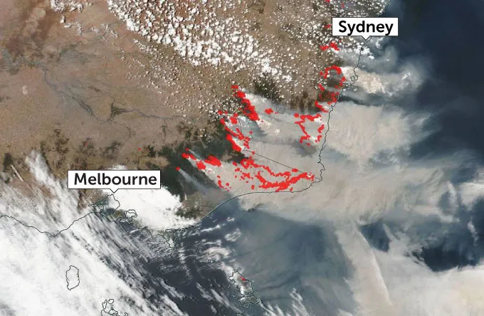
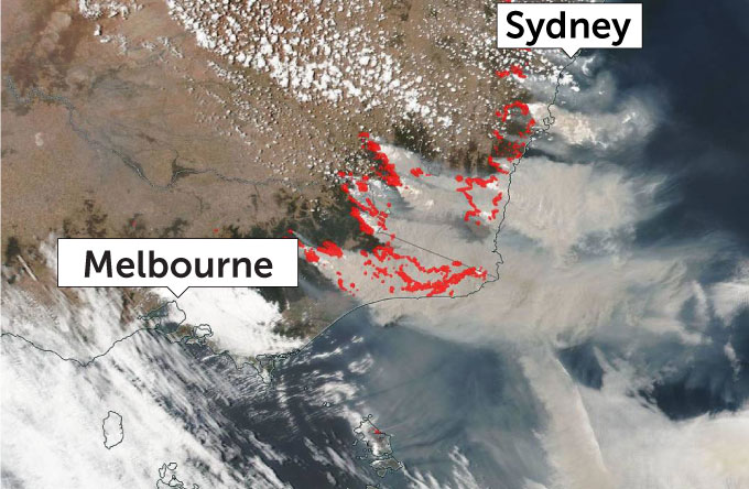
Australia’s fire season normally peaks in late January — but as of January 2020, wildfires have already been raging in the country for four months, especially in the east. So far, the fires have destroyed more than 1,300 homes, burned about 6 million hectares and killed at least 24 people.
Those wildfires are being fueled by a combination of record high temperatures, long-term drought, very low air and soil moisture going into the normal fire season, and human negligence. But climate change, scientists say, could make such extreme, deadly blazes three times as common by the end of the century.
It’s difficult to directly identify the fingerprints of climate change in the blazes. But for years, Australia’s fire managers have kept an eye on one culprit that’s behind particularly hot, dry years in eastern Australia and that may be affected by global warming: an oscillating El Niño–like ocean-atmosphere weather pattern that begins in the Indian Ocean.
Like El Niño, this “Indian Ocean dipole” pattern has positive, negative and neutral phases, depending on whether eastern or western Indian Ocean waters are warmer than average. The more extreme the temperature difference between the ocean’s eastern and western regions, the stronger the phase. When the Indian Ocean dipole is in a particularly strong positive phase — as it was in 2019 — it correlates to some of Australia’s worst fire seasons, says climate scientist Wenju Cai of CSIRO who is based in Melbourne, Australia.
Global warming is likely to make such extreme positive phases much more common, Cai says. In a 2014 study in Nature, he and colleagues simulated future sea-surface temperature changes in the Indian Ocean in a world where greenhouse gas emissions continue on a “business-as-usual” track (SN: 1/7/20). The team found that, under that scenario, the frequency of extreme positive-phase events could increase from about once every 17 years to about once every six years.
Science News talked with Cai about the historical link between the Indian Ocean dipole and Australian fires, and the outlook for the current fire season. His responses are edited for brevity and clarity.
SN: What exactly is a positive phase of the Indian Ocean dipole?
Cai: It’s when the eastern Indian Ocean is cooler than normal, and the west is warmer than normal. When you have [that], the rain moves toward the west. That’s why we’re seeing huge impacts in East African countries. This year, the rains, flooding and landslides have killed more than 300 people and affected hundreds of thousands.
On the eastern side, we tend to have drought and wildfires in Indonesia and Australia. In southeastern Australia, for example in Melbourne, the rainy season is normally June through November. That’s also when the Indian Ocean dipole normally develops.
So if there isn’t rain during those months, it will build up these dry conditions. Trees and vegetation die, and [wildfire] fuel builds up. The summer is the dry season anyway, and we often have bushfires. But [without spring rains], they become much more severe and damaging because it’s so much easier for vegetation to burn.
SN: Meanwhile, one of the worst droughts on record is also occurring in southeastern Australia.
Cai: Yes, we are in a dry season that is already suffering from the impacts of two previous dry seasons. We have this kind of three-year drought regularly in Australia. It’s a very dry continent anyway, particularly in the south. It’s one of the driest regions in the world.
But you have a cumulative effect now, because the soil moisture is very low, and then this dipole comes about, and we also accumulate a lot of [wildfire] fuel.
SN: Is there a link between the positive-phase dipole and wildfires in eastern Australia?
Cai: There’s a very good correlation: All the major bushfires in southeastern Australia are preceded by [a positive] Indian Ocean dipole. For example, in 2009, [such a dipole preceded] a bushfire called Black Saturday that killed 173 people in Melbourne in just a few hours, and destroyed more than 2,000 houses.
There was also a [positive] dipole before the 1997 bushfire in Indonesia, which lasted many months and created haze affecting tens of millions of people and really hit the economy there. The 2019 dipole is second [in strength] only to 1997 in the historical record going back to 1870.
SN: So what’s the link to climate change?
Cai: The big message of our 2014 paper is that, under global warming, that kind of huge Indian Ocean dipole will increase threefold by 2100.
In a subsequent paper in Nature Communications, we also looked at how the frequency of the dipole would change if temperatures are stabilized [at] 1.5 to 2 degrees Celsius [above preindustrial times]. The good news is that really cutting greenhouse gas emissions is actually very effective! Once you cut them, it stabilizes [the dipole].
SN: The peak of Australia’s fire season is still ahead. What’s likely to happen?
Cai: The dipole has subsided — it doesn’t survive into December. But the dry season normally lasts until March. What could really stop the fire is substantial rain. If we are lucky, we may have some autumn rain. But autumn rain [in southeastern Australia] has been decreasing over the last 40 years as well. That’s due to a different mechanism that’s also linked to greenhouse warming.
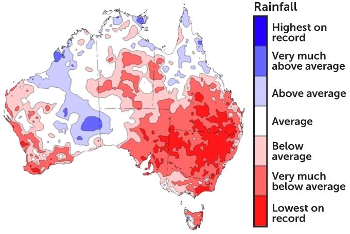
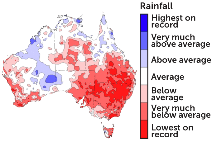
Rain deficit
The year 2019 was both the hottest and driest on record for all of Australia. Southeastern Australia was particularly primed for fire, thanks to a three-year-long drought: Many parts of the region saw record-low rainfall (dark red) from 2017 to 2019.
SN: What mechanism is that?
Cai: Air over the tropics, the tropical Pacific for example, rises and carries a lot of moisture and heat that gets transported to the mid-latitudes. When it’s dry and cold, the air sinks down. So [during the summer heat], where Melbourne sits, the air is very dry.
[Historically, that dry zone shifts northward during cooler months, bringing rain to southeastern Australia.] But [cold season] rainfall has been decreasing in the region. The long-term trend is that the dry zone has been expanding, from north to south, due to greenhouse warming. Basically, I’m hoping for autumn rain, but predicting it is very difficult.


