Katrina’s legacy: Refining hurricane forecasting

10 years later, lessons learned could save lives in next killer storm

helicopter

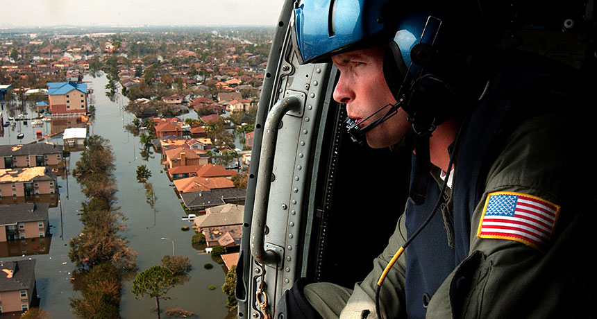
HOPEFUL FORECAST  A decade after Hurricane Katrina devastated the Gulf Coast, the storm’s legacy of destruction continues to spur life-saving storm forecasting improvements. Katrina killed nearly 2,000 people and flooded huge swaths of New Orleans (shown).

Petty Officer 2nd Class NyxoLyno Cangemi/Wikimedia Commons

Ten years ago, the sea and sky rallied to unleash one of the worst natural disasters in U.S. history. During the 2005 Atlantic hurricane season, the most active season on record, 27 named storms —from Arlene to Zeta — swirled into existence. By far the most destructive was Hurricane Katrina.

Katrina killed nearly 2,000 people and caused an unprecedented $108 billion in damage from the time of its formation over the Atlantic Ocean on August 23, 2005, to its final demise eight days later near the Great Lakes.

Yet the disaster also left an enduring — and far more positive — legacy. It has been a driving force for innovations in storm forecasting. Weather gurus say a Katrina-level hurricane will strike the U.S. coast once every 14 years on average. When the next one hits, advances in science and technology will allow earlier and more precise predictions of the storm’s path and its surging floodwaters. Forecasters are also working on ways to get a better handle on what triggers a storm’s often unpredictable intensification.

These improvements will ultimately save lives, says Kathryn Sullivan, administrator of the National Oceanic and Atmospheric Administration. “We know we still have work to do,” she says, but “we’re in a much better place now because of the investments we’ve made over the last decade.”

When Katrina was born out of the remnants of a previous storm over the Bahamas, no one suspected that it was just days away from causing massive devastation in New Orleans. The spiraling storm picked up strength and reached hurricane status less than two hours before making its first landfall in southeastern Florida, where it passed directly over the National Hurricane Center in Miami. After losing steam during its cross-Florida jaunt, Katrina revitalized over the warm waters of the Gulf of Mexico. It reached Category 5, the highest designation, a day before slamming into the Louisiana coast, but weakened to a Category 3 before making landfall.

The storm’s powerful winds, clocked at over 200 kilometers per hour, shoved seawater inland. This storm surge reached over 8 meters above mean sea level, the highest ever seen in the United States. A levee system constructed to divert storm waters away from New Orleans burst in multiple places, sending floodwaters pouring into residential neighborhoods. At the height of the disaster, about 80 percent of New Orleans was underwater, more than 4 meters deep in places.

Katrina’s devastating storm surge highlighted the ineffectiveness of the current hurricane category system to adequately convey hazards, says meteorologist Rick Knabb, director of the National Hurricane Center. The Saffir-Simpson Hurricane Wind Scale rates hurricanes based on their peak sustained wind speed. But a hurricane’s floods typically cause more damage than its winds do. The widespread destruction of the storm surges of relatively weaker storms, such as 2012’s Hurricane Sandy, was largely due to an onslaught of seawater. From 1963 through 2012, storm surges caused nearly half of all hurricane fatalities; winds caused about one in 10 deaths, Knabb says.

Story continues below map

In 2017, NOAA will launch a new supplemental warning system aimed at communicating the flood risks posed by incoming storms. The prototype mapping system combines multiple storm and flood simulations with detailed land elevation data to precisely predict where and how high above the ground floodwaters will rise. That information can help emergency managers determine which areas to evacuate. This system does not, however, account for breaches or the overflowing of levees, both of which occurred during Katrina.

While the new flood map is still two years out, other improvements are in place now. Over the last 10 years, hurricane path predictions have become more accurate on every timescale from hours to days in advance.

Advances in computer hurricane forecasting now allow meteorologists to simulate multiple storms simultaneously to account for interactions between weather systems. GOES-R, a new weather-watching satellite slated for launch next year, should take these advances even further. The satellite will collect data five times as frequently as current U.S. weather satellites do and provide 60 times the information, says Steve Goodman, senior scientist for the GOES-R program. In the coming years, NOAA hopes these improvements will extend forecasts from five to seven days and provide earlier warnings of gathering storms.

These accurate storm track predictions should result in tighter evacuation zones, easing traffic jams before a hurricane hits, says meteorologist Louis Uccellini, director of the National Weather Service in Silver Spring, Md. It also could help people take warnings more seriously — fewer would get false alarms to flee, he says.

Despite all these improvements, storm forecasters still have a major blind spot: storm strength.  Meteorologists can’t fully explain why storms occasionally strengthen suddenly (SN Online: 3/20/15). Huge cloud columns called hot towers appear near the center of some hurricanes just before they rapidly strengthen. With Hurricane Katrina, these hot towers appeared before the storm intensified to a Category 5. Scientists don’t know whether these hot towers were the result or cause of hurricane intensification. If they can figure that out, the information could improve intensity forecasts.

While some of these improvements have been used to track typhoons over the Pacific Ocean, major tests of hurricane forecasting improvements in the Atlantic are yet to come. No hurricanes have made landfall along the U.S. coast at Category 3 or above since Hurricane Wilma in 2005 (SN Online: 4/17/15). “When each one of these [hurricanes] comes, you find the vulnerabilities in the systems you’ve designed,” says Lt. Gen. Thomas Bostick, commanding general of the U.S. Army Corps of Engineers.

The hurricane drought probably won’t end during the current hurricane season, NOAA reported August 6. The agency’s Atlantic hurricane outlook calls for a 90 percent chance of a below-normal season — just two or fewer major hurricanes — and a 10 percent chance of an average season, with one to four major hurricanes. That’s the highest probability for a below-normal season given by NOAA since seasonal outlooks began in 1998.

Such a quiet season is largely due to the ongoing El Niño, an eastward shift in warm Pacific seawater that disrupts global weather patterns. The current El Niño is on track to be one of the strongest on record, scientists say (SN Online: 7/16/15).

Strong El Niño years often precede strong La Niña events, however, which can turbocharge Atlantic hurricane seasons. If the current El Niño gets a blockbuster La Niña sequel, the next big hurricane landfall could be just a year or two away. When it comes, forecasters say, they’ll be ready.

More Stories from Science News on Climate