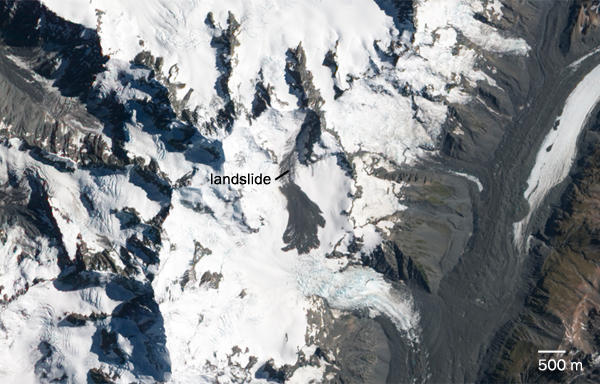
A computer and a comfortable chair may be all that’s necessary to investigate catastrophic landslides in the farthest reaches of the world. Researchers have developed a way to remotely detect the events using energy unleashed by landslides, just as geologists identify earthquakes using waves of energy.

The technique provides a three-dimensional look at a landslide’s trajectory down a slope. As a result, it may help scientists unravel the complicated physics governing these natural disasters, the researchers report March 21 in Science. The method also provides data that could inform landslide hazard assessments, says Steve Evans, a geomorphologist at Canada’s University of Waterloo, who wasn’t involved in the work.
A landslide strikes when erosion and other factors weaken a steep cliff. Once friction can no longer hold rocks in place, a mass of debris will fall down a slope, sometimes for many kilometers before stopping. Such rock avalanches can kill people, destroy villages, block valleys and dam up rivers.
Although these events can be destructive, officials may not realize for days that a landslide has occurred in a remote area, says study coauthor Colin Stark, a geophysicist at Columbia’s Lamont-Doherty Earth Observatory in Palisades, N.Y. Faster landslide detection could speed up rescue operations.
In the last several years, researchers have realized that, like an earthquake, a landslide creates seismic waves that travel through Earth’s crust. These waves have a distinct pattern because landslides occur steadily over a couple of minutes, rather than creating a burst of energy in a few seconds as an earthquake does.
When global sensors pick up a seismic event that doesn’t correspond to an earthquake, Stark and seismologist Göran Ekström, also of Lamont-Doherty, check whether it’s a landslide. From seismic data alone, the pair can calculate the landslide’s magnitude, its location to within 100 kilometers and the direction the landslide traveled. The researchers check satellite images to confirm the event was a landslide. By combining seismic and satellite data, the team can estimate the length of the landslide’s path and the mass of debris that fell. The process of identifying a landslide can take a day or two, Ekström says.
There’s still room for improvement. Right now, the method can only detect giant landslides that dislodge millions of metric tons of debris and unleash at least as much energy as a magnitude 4.5 earthquake. And without satellite images, it would identify 10 times as many false-positives as it would true landslides, David Petley of Durham University in England points out in a commentary published in the same issue of Science. Ekström hopes that he and Stark can develop a better way to distinguish a landslide without relying on satellite imagery.
In addition to detecting landslides, the method may help explain some of their mysteries. “They’re very complex and do rather strange things,” Stark says. With the seismic and satellite data, he and Ekström can calculate changes in a landslide’s acceleration and construct its trajectory — data that researchers need to build simulations of landslide motion. Since landslides are unpredictable and happen so quickly, Ekström says, this information is usually hard to get; scientists don’t have time to put instruments in place to collect real-time measurements.
Instead, they usually travel to the site after the rock avalanche and, like crime scene detectives, put clues together to reconstruct what happened. “These field approaches,” says geologist Randall Jibson of the U.S. Geological Survey in Golden, Colo., “can be long and painstaking.”
And that’s only for landslides that people know about. With seismic signals, the researchers’ technique can discover landslides that would otherwise go unnoticed. In 2010, for example, Stark and Ekström detected 11 landslides, only four of which were also identified by traditional means.


