Map yields new view of ancient city
An international team of scientists has assembled a map of the world’s largest preindustrial city, the sprawling settlement of Angkor in what’s now Cambodia. The new map shows that Angkor’s ruins cover more than 1,000 square kilometers, including areas outside boundaries that have been established to protect the archaeological site.
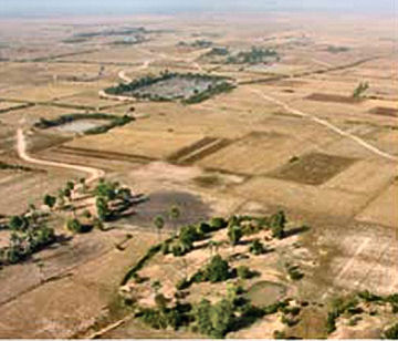
It’s now evident that an elaborate canal system once supplied water throughout Angkor, say Damian Evans of the University of Sydney in Australia and his colleagues. Although the city prospered for 6 centuries and reached a peak population of nearly 1 million residents, its reliance on canals for water led to its collapse in the 1500s, the researchers contend.
Overpopulation and massive clearing of forests for rice fields contributed to erosion that filled the canals with sediment. Attempts to revamp the canals proved unworkable, Evans’ team asserts in an upcoming Proceedings of the National Academy of Sciences.
Angkor has been studied for more than 100 years. It’s best known for Angkor Wat, a massive 12th-century temple.
Evans and his coworkers constructed the new map by combining information from maps drawn about 20 years ago, recent ground surveys, aerial photography, and ground-sensing radar deployed on the space shuttle in 2000. The effort identified at least 74 formerly undetected temples, each surrounded by a moat, and more than 1,000 artificial ponds that were used for water storage.