Ocean current simulations could narrow Flight 370 search

If recently found wing debris is from missing Malaysian plane, it probably came from north half of suspected crash zone

Aircraft debris

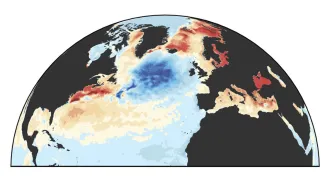
LOST AT SEA  Ocean current simulations show that aircraft debris found on Réunion Island east of Madagascar could have originated from the northern half of Malaysia Airlines Flight 370’s search area.

Lucas Marie/AP

Update: On September 3, French investigators confirmed that the airplane wing fragment discovered on an island in the southwestern Indian Ocean originated from the missing Malaysia Airlines Flight 370. While this confirmation provides clues about the lost flight’s fate, definitively pinpointing an exact crash site or other wreckage using ocean currents remains challenging.


A washed-up wing fragment near Madagascar could help narrow the search area for the Malaysia Airlines Flight 370 crash site, new ocean current simulations suggest.

Leads have been few and far between since Flight 370 vanished over the South China Sea in March 2014. On July 29, searchers got a potential break. A roughly 2-meter-long section of a Boeing 777 wing, the same type of aircraft as Flight 370, was found on Réunion Island in the southwestern Indian Ocean.

Aeronautic experts have yet to link the debris back to the missing aircraft. But simulating how Indian Ocean currents ferry debris, Fedor Baart and Maarten van Ormondt have traced how aircraft wreckage could float from the vast search area near Australia to Réunion. Both hydrodynamicists work for Deltares, a flood assessment research institution in Delft, the Netherlands. The simulations indicate that the wing fragment could have originated from the Australia-sized search area’s northern half. Debris from the southern half would more likely make landfall in Western Australia, the researchers found.

A large, swirling ocean current spins counterclockwise between Australia and Africa. This gyre acts like a roadway roundabout, with material circling and occasionally exiting the revolving current.

Simulating the gyre and nearby currents, Baart and van Ormondt dropped a thousand digital particles in both the southern and northern halves of Flight 370’s search area. As the particles drifted, the researchers noticed that particles from the northern half began arriving along the African coast within a year of release time. Particles from the southern half mostly meandered around a more sluggish part of the gyre. A handful drifted toward Africa, but didn’t hit land within the simulation’s 17-month timeframe.

The simulation can’t definitively determine where the debris came from, but “it’s plausible it came from somewhere in the search area,” van Ormondt says.

The search had been focused further south in the suspected crash zone, says Annalisa Bracco, an oceanographer at Georgia Tech in Atlanta. “Hopefully this will help people locate the remaining debris underwater.” 


FLOW CHART

Using a simulation of the Indian Ocean’s currents, researchers charted possible routes that debris from the northern (green dots) and southern (gray dots) halves of the Flight 370 search area could have taken. In the time since the plane went missing, only particles from the northern half could have reached the African coast, the simulation suggests.

Credit: F. Baart

More Stories from Science News on Oceans

From the Nature Index

Paid Content