At 5:12 a.m. on April 18, 1906, the residents of San Francisco awoke with a start as a massive temblor ripped along the San Andreas fault. The shifting earth turned liquid, and buildings shook from their foundations. Subterranean gas pipes fractured and fueled fires that in the following 3 days would consume more than 10 square kilometers of the city. The blazes couldn’t be extinguished because the city’s water pipes had been fractured too.

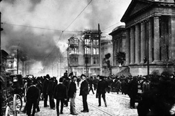
The quake and subsequent fires destroyed about 28,000 buildings, causing an estimated property loss of $524 million. At the time, the estimated death toll from the event was about 300, but subsequent interviews with survivors suggested that the actual number of fatalities might have been 10 times as high.
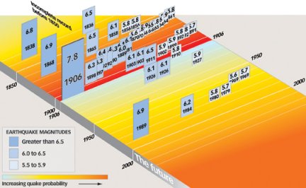
Using data gathered during and soon after the temblor, scientists estimated the quake’s magnitude at about 7.9. Since then, the Bay Area hasn’t experienced a seismic shock that large. The biggest was magnitude 6.9 in 1989 in the mountains south of San Francisco. Today, the area’s residents wonder about when and where the next “Big One” will occur.
The century long lull in major quakes will probably end sometime in the next 30 years, according to seismologists’ latest estimates.
A repeat of the 1906 quake would be as devastating to the Bay Area as Hurricane Katrina was to New Orleans. Insurers estimate that the costs of rebuilding would range between double and triple the amount of the annual California state budget. In an attempt to forestall some of that damage, billions are now being spent to seismically upgrade the region’s bridges, pipelines, and other infrastructure. However, relatively little of that money is being spent to strengthen homes and apartment buildings—a trend that will ensure demographic upheaval when the inevitable quake occurs.
New analyses of seismic data gathered during the 1906 quake, as well as field observations made soon thereafter, suggest that the San Andreas fault ruptured much more quickly than scientists had previously estimated. Analyses of ground motions indicate that as bad as the destruction was that day, it could have been much worse.
What happened?
In early 1906, San Francisco was the largest and richest city in the western United States. About 400,000 people, a quarter of all residents west of the Rockies, lived there. Banks in the city held deposits exceeding $1 billion, more than all other western banks combined.
Then came the quake.
Slippage along the San Andreas fault, the boundary between the North American and the Pacific tectonic plates, began offshore just west of San Francisco Bay. From that epicenter, the rupture spread along the fault to the southeast and the northwest, says Mary Lou Zoback, a geophysicist with the U.S. Geological Survey (USGS) in Menlo Park, Calif. Slippage occurred along almost 500 kilometers of the fault, the longest known rupture of any fault in the lower 48 states. In San Francisco, the ground shook for 45 seconds to a minute.
The temblor was one of the first to be studied scientifically, Zoback notes. Data gathered by researchers nearly a century ago are still yielding new insights. At the fall meeting of the American Geophysical Union in San Francisco last December, Zoback gave a new perspective on the quake and its aftermath.
Seismology was a fledgling science in 1906. There were only 96 seismometers operating worldwide at the time, five of them in and around San Francisco. However, ground motions generated by the rupturing fault were so large that measurements made by the local instruments were literally off the chart—and therefore useless. For scientists then and now, some of the most useful data about the quake were recorded by distant instruments in Japan, Puerto Rico, and Europe, says Gregory C. Beroza, a seismologist at Stanford University.
Different types of analyses produce different estimates for the quake’s magnitude and the length of fault rupture, says Beroza. Analyses conducted soon after the quake—ones that considered the size and duration of the ground motions recorded by remote seismometers—suggested that the quake measured a magnitude 7.7 and that slippage occurred along only 350 km of the fault. That distance estimate matched the length of disturbed earth that field geologists observed at the time—the San Andreas fault was ruptured from just northwest of San Juan Bautista, Calif., to Point Arena, where the San Andreas fault enters the ocean northwest of San Francisco.
Despite that concordance, the magnitude estimated by those methods didn’t match the magnitude calculated from precise surveys of the region after the quake. Those field data hinted that the quake measured a magnitude 7.9 and that rupture occurred along 500 km of the fault—from San Juan Bautista all the way to Cape Mendocino, where the San Andreas fault comes back on shore, farther northwest of Point Arena. Although field teams had noticed disturbed earth at Cape Mendocino after the 1906 quake, scientists at the time couldn’t agree whether that disturbance resulted from the rupture of the fault or an unrelated landslide.
Now, Beroza and his colleagues have developed a model for the quake that removes the discrepancies. The problem with previous seismic analyses is that the researchers assumed that the fault ruptured at a speed of about 2.7 km per second (km/s), a rate typical of small quakes. But Beroza’s team considered data gathered during some recent large quakes, including a magnitude 7.4 temblor in Izmit, Turkey, in 1999; a magnitude–8.1 quake that rocked Tibet in 2001; and a magnitude–7.9 quake in Alaska in 2002. Those data suggest that faults can rupture at speeds exceeding 3.5 km/s, says Beroza.
That velocity is so great that the seismic waves form an intense pressure pulse that’s analogous to a sonic boom in the air. Such pressure pulses can do a lot more damage than the seismic waves that travel at lower speeds can.
When Beroza and his team reanalyzed the seismic data and assumed the San Andreas fault ruptured at high speed, the magnitude of the quake and the rupture length of the fault matched the estimates obtained by analyzing the field-survey data. The researchers presented their findings last December at the American Geophysical Union meeting.
When the San Andreas fault let loose in 1906, the rupture started offshore near San Francisco and, for the most part, spread away from the city, says Beroza. Therefore, most of the seismic energy radiated away from the city, not toward it, and the subterranean pressure pulses didn’t strike San Francisco as forcefully as they would have if the waves had been crashing toward the city from a distant earthquake. The devastation “could have been much worse,” says Beroza. The 1906 quake was one of the least damaging earthquakes of that size that could have struck the region, he notes.
What’s the frequency?
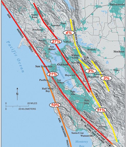
At least seven faults running through the Bay Area can accumulate enough seismic stress to generate quakes of magnitude 6.7 or higher. For such a seismically active region, earthquakes have been rare, at least in recent history. Temblors larger than the 1906 San Francisco quake are even rarer. In the past 3 centuries, there have been no such quakes in the Bay Area and only 30 or so anywhere on Earth.
Seismic instruments haven’t been around long enough to provide researchers with a good idea of how often damaging quakes strike a particular region over the ages. In a sense, though, the Bay Area has had an earthquake-reporting network since the United States was founded.
People in charge of the region’s Spanish missions—the first of which was founded in San Francisco in 1776—diligently kept records of all significant events within their jurisdictions, including natural phenomena such as droughts and earthquakes. Their observations show that the region’s seismic history can be divided into two periods, with the 1906 earthquake as the dividing line.
In the years before the 1906 quake, earthquakes occurred frequently throughout the region, says Zoback. Between 1858 and 1906, for instance, 13 quakes with an estimated magnitude of 6.0 or larger were generated by slippage along the area’s faults, a rate of one quake every 4 years. In the past century, only five quakes of that magnitude have occurred. Scientists speculate that the 1906 quake released a large amount of the seismic stress that had accumulated along the San Andreas fault, and they refer to the dearth of temblors since that event as the quake’s “seismic shadow.” The question is “How long is that shadow?”
To come up with an answer, scientists have scrutinized mission documents, but they’ve also looked for clues in the local geological record. For example, they’ve carbon-dated samples of sediments that were disturbed by quakes that predate those known from mission records. With these sources of information, scientists at the USGS have reconstructed the region’s seismic history since 1600.
A series of large temblors occurred throughout the Bay Area between 1680 and 1776, a cluster that ruptured nearly all of the region’s faults, says Zoback. The San Andreas fault let loose four times in the past 4 centuries—the massive quake of 1906 as well as smaller events in the mid-1600s, the mid-1700s, and in 1838. Big quakes have ruptured the Hayward fault, which runs through the eastern portions of the Bay Area, three times—in the early 1600s, the early 1700s, and in 1868.
The patterns found in these seismic data suggest that the probability of a magnitude 6.7-or-greater earthquake striking the Bay Area before 2032 is at least 62 percent, says Zoback.
It’s uncertain whether the next big quake in the region will mark the end of the 1906 quake’s seismic shadow. Indeed, that pall might have already lifted. The magnitude 6.9 quake of October 1989, which was centered in the Loma Prieta Mountains, might have been the first in a new series of seismic salvos to strike the region. Although that quake released just 3 percent as much energy as the 1906 San Francisco quake did, it killed 62 people and caused more than $5.6 billion in damage.
What’s the damage?
What would happen if a quake the size of the 1906 temblor happened today? Analyses suggest that the devastation would be widespread and even more costly than it was a century ago.
Building codes in San Francisco, as well as those in many other earthquake-prone regions, have evolved over the past century to require stronger construction and better seismic performance. The most recent such updates to San Francisco building codes were enacted in the 1970s, says Zoback. However, more than 84 percent of the residential structures in the city were built before that time.
A 2001 neighborhood-by-neighborhood study, conducted for the city of San Francisco, showed extensive vulnerability in the city’s privately owned buildings, says Zoback. About 70 percent of the damage in the city would be to homes, apartments, and other residential structures.
Neighborhoods in the western and southern areas of the city would bear the brunt of destruction, in large part because of the soft soils there. Citywide, about 45,000 buildings would be destroyed by the quake and subsequent fires, and more than 160,000 families would be left homeless, according to the city’s study.
A major quake would probably cause significant shifts in the city’s demographics, says Zoback. About 65 percent of the people who live in San Francisco are renters, and 71 percent of those residents live in rent-controlled apartments or buildings. Because in many cases those renters are paying much less than market rates for their apartments, owners might actually have an economic disincentive to perform seismic upgrades. If a building is destroyed by a quake and then rebuilt, its apartments would no longer be subject to rent control, and many of the current residents wouldn’t be able to afford to live there.
What’s the outlook?
Although the damages in San Francisco from a large quake would be devastating, scientists suggest that municipalities along the eastern shores of San Francisco Bay are at even greater risk than San Francisco itself.
To better survive such a temblor, the public and private sectors have spent, or will soon spend, about $30 billion to seismically upgrade Bay Area buildings and infrastructure, says David P. Schwartz, a research geologist at the USGS in Menlo Park. He noted at the December 2005 American Geophysical Union meeting that the largest portion of this pie, about one-third, is dedicated to transportation. The state department of transportation has already spent about $3.5 billion to retrofit or replace the region’s overpasses and toll bridges.
Public utilities have spent about $6.5 billion to upgrade the pipelines that bring water to San Francisco, a lifeline that tragically failed in 1906. Also, Pacific Gas & Electric, the main utility provider in northern California, has spent $2.4 billion since 1985 to replace or enhance gas pipelines and power lines with ones that are more resistant to quakes.
Because no one knows when the inevitable Big One will occur, it’s tough to tell whether the race to ameliorate its effects is going well. In many respects, however, efforts are lagging. For example, state legislators in 1994 gave hospitals 2 decades to upgrade their facilities to ensure they could remain open after a large earthquake. Data compiled by the USGS indicate that, so far, only $900,000 of the $5.7 billion needed to meet that target has been spent.
Because of the dearth of big earthquakes in the Bay Area since 1906, “people have a distorted view of the real earthquake hazard,” says Stanford’s Beroza. Sooner or later, one of the seven faults in and around San Francisco will let loose, he notes. It’s not a question of if, but of when.


