Robotic subs reveal thicker Antarctic sea ice

Improved measurements will boost understanding of Southern Ocean

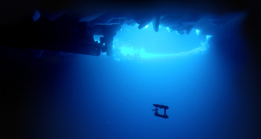
SUB ZERO  Measurements made by remote-controlled submarines suggest that scientists have underestimated the thickness of Antarctic sea ice.

Klaus Meiners/AAD, Post-processing: Peter Kimball/WHOI 

The sea ice surrounding Antarctica may be thicker than previously thought. Earlier estimates using shipboard observations and drill cores had suggested that the Southern Ocean ice pack was thinner than 1 meter on average. New measurements, reported November 24 in Nature Geoscience, show ice floes with thicknesses ranging from 1.4 to 5.5 meters, with some areas as thick as 16 meters.

“We have a fairly good sense that this ice may represent a significant portion of the pack,”says study coauthor Ted Maksym, an oceanographer at the Woods Hole Oceanographic Institution in Massachusetts.

Thicker ice is less prone to melting, Maksym says. So the improved measurements —made during the first extensive use of robotic submarines in the Antarctic —could help scientists better understand why the Antarctic ice pack has expanded overall since 1979 despite rising water and air temperatures (SN Online: 11/5/12).

Accurately gauging ice pack thickness poses a challenge because roughly 90 percent of the ice hides in the water. Satellites can measure the extent of sea ice, but can’t estimate the total volume without on-the-ground estimates for calibration.

Previous ground measurements relied on hand-cranked drills and tape measures as well as visual observations made from icebreaker ships. For safety reasons, ships avoid areas with denser ice, so most expeditions focused on the thinner ice further out to sea. This approach bypassed thick ice closer inland and ice that is deformed when strong winds force two ice floes to overlap and refreeze as one thicker chunk.

To get a more complete picture of the ice pack, Maksym and colleagues repurposed autonomous underwater vehicles, or AUVs, to look at the floes from below. Each remote-controlled vehicle weighs around 200 kilograms and has a double-decker design with two torpedo-shaped hulls. The AUVs were originally designed to map the seafloor, but the team reconfigured them to instead probe the underside of the ice above using sonar. By measuring how far the ice protruded below the surface, the team could calculate the total ice thickness.

Cruising in a grid pattern at around 1 kilometer per hour at a depth of 20 to 30 meters, the AUVs mapped 10 ice floes during two expeditions in 2010 and 2012. In total the robo-subs scoured 500,000 square meters of ice, about the size of 100 football fields.

On average, the ice floes were 1.48 meters thick, though the researchers say the limited area covered by the expeditions prevents them from making estimates for the Southern Ocean ice pack as a whole. Measuring the same ice floes using conventional methods would have underestimated the ice thickness by at least 20 to 25 percent, says oceanographer Guy Williams of the University of Tasmania in Hobart, Australia.

“This is a huge leap forward,”he says, “and I don’t think it’ll be possible to go back to those other methods.”

In addition to the ice thickness, the AUVs also recorded a surprising amount of deformed ice. In total, 76 percent of the ice pack was cobbled together from multiple hunks of ice that had broken and refrozen together. Deformed ice is important for the marine ecosystem, Williams says, because krill and other animals use fractures in the ice for shelter from strong currents and predators such as penguins.

An improved understanding of sea ice composition will help scientists running ocean and atmosphere simulations better understand Antarctic sea ice expansion, says geoscientist Hongjie Xie of the University of Texas at San Antonio. “If we don’t understand the physical process of sea ice, the modeling will give us results that are meaningless or misleading,”he says. No consensus exists on what is causing southern sea ice expansion, though proposed mechanisms include changing wind patterns caused by the ozone hole and increased melt water from shrinking Antarctic glaciers (SN: 5/4/13, p. 18).

NASA’s ICESat-2 satellite, slated for launch in October 2017, could provide answers, says climate scientist Claire Parkinson of the NASA Goddard Space Flight Center in Greenbelt, Md. The satellite will continually monitor ice extent around both poles and will estimate sea ice thickness by measuring how far ice extends above the waterline. Those estimates require precise on-the-ground measurements for calibration, Parkinson says, and will probably necessitate extensive AUV missions in tandem with the satellite mission.

More Stories from Science News on Oceans