POOF Most of the debris from the 2012 eruption of Havre (shown), a deep-sea volcano near New Zealand, ended up in a pumice raft that floated across the South Pacific.
Univ. of Tasmania in Australia, Woods Hole Oceanographic Institute
On July 31, 2012, Maggie de Grauw looked out the window of her flight back to New Zealand after a holiday in Samoa and glimpsed a mysterious mass floating below. That mass turned out to be a raft of lightweight pumice rock, the product of an erupting underwater volcano called Havre. The 2012 eruption turned out to be the largest of its kind in the last 100 years. And now, the pumice raft has become a crucial clue in revealing the eruption’s surprisingly complex nature.
Although underwater eruptions happen all the time, scientists have only recorded such events since the 1990s, and pumice rafts can often float under the radar. Typically, researchers use depth sensors aboard ships to examine the crime scene of an underwater eruption.
But “what we found on the seafloor was almost entirely different from what we expected,” says Rebecca Carey, a volcanologist at the University of Tasmania in Australia. Havre challenges the reliability of the geologic record when it comes to big deep-sea eruptions.
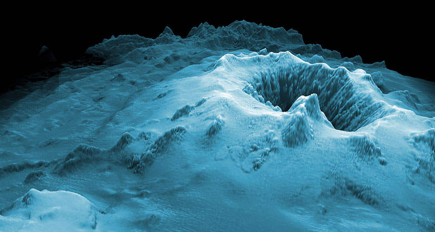
In 2015, Carey and her colleagues set out to get a more detailed view of Havre’s big outburst than what ship-based sensors could reveal. The researchers deployed a robot to measure the depth of the 4-kilometer-wide caldera. Another robot, operated remotely from a ship, allowed the team to get a closer look at specific features in and around the caldera, and to take rock and water samples. A bit of satellite-image detective work revealed the size and path of the pumice raft, which formed no more than 21 1/2 hours after the eruption ended.
The robotic diving duo provided a high-resolution topographic map of the underwater posteruption landscape. The map shows a massive rupture, lava from 14 different vents ranging from 900 to 1,220 meters below the surface, chunks of pumice, landslide deposits and a blanket of ash. This diversity of volcanic material was unexpected, the researchers write January 10 in Science Advances.
Although the Havre event was larger than the 1980 eruption of Mount St. Helens, a similar type of volcano that shot a huge column of debris into the air, the seafloor data weren’t indicative of such a large eruption. “When you shoot a lot of material up into water, there’s resistance,” Carey says. “So you expect to see a lot of it deposited on the seafloor.” But using an old seafloor map of Havre and satellite data, Carey and her colleagues calculated that more than 75 percent of the material produced by Havre ended up in the 400-square-kilometer pumice raft. That raft eventually broke apart and washed up on Australian and other South Pacific beaches. Volcanic gases might have pushed debris to the surface, Carey speculates, but it’s impossible to pinpoint a cause.
Many submarine eruptions go unnoticed, and few have been mapped in this manner. Frequently, researchers rely only on clues on the seafloor surface to determine an eruption’s size. And, if Carey’s team had just done that, the researchers would have never known the true size and nature of the eruption.
“That is a real eye-opener from this study,” says Bill Chadwick, a volcanologist at the National Oceanic and Atmospheric Administration’s Pacific Marine Environmental Laboratory in Newport, Ore. “What they found tells us a lot about how submarine eruptions behave differently than those on land.”
And if the Havre data are any guide, previous estimates of underwater eruption size may be off. “Now we know that the geological rock record is unfaithful to these very large magnitude powerful events,” Carey says.
ROUGH TERRAIN Underwater robots helped map Havre’s 2012 eruption, creating elevation maps of the site and allowing researchers to figure out the volume of volcanic debris deposited there. |


