Tsunamis circled the globe after a magnitude 9.3 earthquake struck the Indian Ocean last Dec. 26 (see “Earthshaking Event,” in this week’s issue). However, those waves didn’t spread evenly, says Vasily Titov of the National Oceanic and Atmospheric Administration in Seattle. Computer models suggest that the largest waves (orange zones) initially moved perpendicular to the rupturing fault (black boxes in inset). Then, the deep-reaching waves were guided by midocean ridges, Titov and his colleagues report in an upcoming Science.
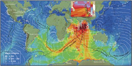
Tide data show that tsunami heights in Nova Scotia, Mexico, Peru, and Chile—all more than 20,000 kilometers from the earthquake’s epicenter—topped 50 centimeters, even though the wave height at Cocos Island, just 1,700 km south of the epicenter, measured only 30 cm.


