Seeing Past the Dirt
Using ground-penetrating radar to focus archaeological digs
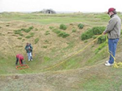
Behold the modern archaeologist in the field: no pick, no shovel, no whisk broom. On this day, the only equipment that’s apparent is a cart full of electronics, which the researcher is pushing back and forth over the ground. The activity recalls a homeowner mowing a lawn, but this is instead high-tech prospecting with ground-penetrating radar. A flickering screen on the cart reveals echoes of buried objects, reflections that may represent artifacts, structures, or other signs of civilizations long ago.
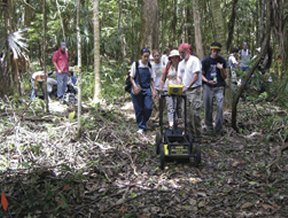
Mapping out subsurface features with radar enables scientists to focus their excavations more narrowly than they ever could before. No more cursory, wide-ranging digs based on hunches that something interesting might turn up. Besides saving archaeologists a lot of digging, time, and money, ground-penetrating radar permits them to study sites that are considered off-limits to physical disturbances.
Where radar turns up objects worth digging for, archaeologists can apply their shovels precisely and spare landscapes from much of the scarring that less-directed digging brings.
The radar equipment, like most electronics, is growing ever more capable and affordable. Radar reveals buried objects by comparing their density or electrical differences with those of surrounding material. In some cases, it detects fist-size objects a meter into the soil.
As some archaeologists turn to this modern equipment to study sites that date back thousands of years, others are using it to fill in the blank pages of more-recent history. By studying a World War II battleground, for one, researchers have uncovered previously unrecognized military innovations that the Nazis used during their occupation of France.
Seek, and ye shall find
For teasing out the details of everyday life for long-gone peoples, it’s often the small artifacts that say the most. Large structures such as Maya buildings or Egyptian pyramids, though easy to spot and study, don’t tell the whole story. Many clues about life at such sites are found at smaller scales, such as within the living quarters, storage sheds, and garbage pits of ancient civilizations.
Typically, the environment has reclaimed small, everyday objects. They lie buried under a leaf-littered forest floor, a sand dune, or layers of sediment. With ground-penetrating radar and other so-called geophysical technologies, such as gradiometers that can detect small variations within a magnetic field, researchers can limit their excavations, says Armin Schmidt of the University of Bradford in England. When digs are less invasive, researchers can leave large portions of a site undisturbed and therefore in their original context, he notes.
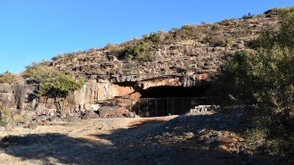
Take, for example, the Iron Age site of Muweilah in the United Arab Emirates. The sand-covered site was discovered in 1988, but scientists didn’t begin extensive excavations there until 1994. Over the next 7 years, teams of archaeologists primarily from the University of Sydney in Australia excavated the foundation of an approximately 100-square-meter, multiroom structure that probably served as living quarters for members of the community. Researchers also excavated, from beneath about a meter of sand, remnants of a large columned building that may have been the political and economic center of the community, says Ryz Evangelista, a geophysicist who studied the site and now works for the resource-exploration company WMC Resources in Belmont, Western Australia.
After these big digs, the researchers in 2001 turned to radar to investigate two unexcavated 20-m-by-50-m plots near the uncovered buildings. Tests suggested that the radar could reveal sections of mud-brick walls as much as 5 m down into the sand.
Without turning a shovel, the scientists discovered large structures and small artifacts. In one of the areas, Evangelista and her colleagues took about a month to collect radar data along paths spaced 25 centimeters apart. Across the eastern portion of this plot, about 1 m beneath the surface, the radar showed two walls made of stones and mud bricks. Those walls probably marked the outer rim of the community, the researchers say. The radar scans also revealed fragments of some other sort of walls near the center of the grid.
Excavation of a single hole just a couple of meters across revealed that one of those walls was made solely of mud bricks, like those of the presumed living quarters previously excavated. A large, horizontal and hard-packed layer that showed up on radar probably denotes the surface of an ancient courtyard. Small radar blips just above the dense layer suggest that the now-buried courtyard may be littered with artifacts, such as fragments of locally produced pottery, or with discarded stones from construction projects, such as the rocks found in the large excavations at Muweilah.
In the second plot, radar scanning detected no walls but revealed a sloping surface of hard-packed sand, possibly another courtyard. One large rectangular object—buried at a depth of about 30 cm, which is well above the level of the courtyard—probably dates from a more-recent era. Because the item might be refuse from a previously undocumented expedition, the researchers haven’t yet decided whether to dig down to it.
Without ground-penetrating radar and other geophysical technologies, Evangelista says that it probably would have taken much longer to find areas of possible archaeological interest beneath the sand at the Muweilah site. The techniques obviate the need to fully excavate the site to unearth its major features, a process that could take as many as 20 years, she adds.
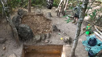
Radar has proved its worth in the jungle as well. Julie A. Aitken of the University of Calgary in Alberta and her colleagues have used radar carts to probe beneath the forest floor at the ancient Maya site of Maax Na, discovered in Belize in 1995. The site was probably occupied from about 350 B.C to A.D. 300, says Aitken. Large aboveground structures, including stone temples, administrative buildings, and pyramids, surround a 100-m-by-150-m plaza, some of which has been thoroughly overgrown by the jungle.
Early excavations at the plaza revealed several layers of buried stonework, each of which served as a pavement for the open area during a different time of the settlement’s history. After proving that radar could detect these features, Aitken in 2004 conducted scans of two other areas of the plaza. The surveys showed blips of various sizes that could represent broken pottery, altars, and caches of ceremonial objects. Archaeologists plan to excavate those areas in future digs, Aitken said in May at the American Geophysical Union meeting in New Orleans.
Treading lightly
In some instances, the nondestructive nature of radar and other geophysical technologies makes archaeology possible at sites that must remain untouched.
Consider the Kolomoki Mounds archaeological site near Blakely, Ga. Many researchers regard that locale as one of the most important in the southeastern United States of the woodland period, a stage in the cultural evolution of Native Americans of that area from 1000 B.C. to A.D. 900, says Nina Serman of the University of Georgia in Athens. The site once held at least eight large burial mounds and is well known for its exquisite ceramics.
Despite its archaeological importance, the site and its previous occupants aren’t well understood. The site was placed on the National Register of Historic Places in 1966, a U.S.-government designation that restricts archaeological excavations. Nevertheless, radar and other techniques that avoid digging are uncovering some of the site’s story.
Along a tree line, radar has identified buried features that may be signs of habitation, including the postholes of long-deteriorated structures and pits that may have been used for holding food, fires, or trash. Within the same area, sensitive gradiometers detected magnetic signs of cooking hearths and pot fragments. Fire baking often changes or eliminates the magnetic field within a material, a characteristic that can distinguish it from surrounding sediments.
Together, these findings suggest that this patch of ground was once a densely populated, permanent settlement, Serman reported at the American Geophysical Union meeting in New Orleans. Her colleagues may perform limited excavations to further investigate the evidence as soon as this fall, she told Science News.
Minimally invasive archaeology can come in handy in areas typically considered off limits, such as battlefields where countries commemorate fallen soldiers. Some of the most sacred battlegrounds of World War II are those along the beaches of Normandy in France, where Allied forces stormed German fortifications on D-day, June 6, 1944.
At Pointe du Hoc, on cliffs overlooking two of the D-day beaches, the Germans constructed a forward command post and numerous bunkers, says Mark E. Everett, an archaeologist at Texas A&M University in College Station. Historians haven’t found any German documentation that shows exactly what was built at the site, how it was built, or what materials were used. Recollections of the site provided by U.S. and British soldiers during and after the war are sketchy, Everett notes.
“Nobody really knows what’s [buried] down there,” says Everett. That’s why he and his colleagues sought permission from the American Battle Monuments Commission to investigate the site with radar carts, metal detectors, and gradiometers.
Many of the results aren’t surprising. Radar has detected fragments of ordnance in some bomb craters as well as the buried remains of a line of machine-gun emplacements and a steel-reinforced concrete trench. However, one of the most enigmatic features at Pointe du Hoc is a cliff-top circle of dead grass that measures 7 m across. It’s probably too large to be a gun emplacement, says Everett. Instruments have indicated long, metallic objects stretching away from the hub of the circle, which has led the researchers to speculate that it marks the buried remains of a railway turntable. Such a turntable could have been the hub of a narrow-gauge railway used to shuttle ammunition, guns, or heavy equipment around the site, says Everett. He presented his team’s results at the New Orleans meeting.
The researchers’ findings may be used to guide a limited number of future excavations. Moreover, in areas that won’t be disturbed by digging, the scanning results could be shared with tour guides who would pass along the site’s hidden history to visitors, says Everett.
Holes in history
In another example of archaeological techniques revealing World War II history, Lawrence E. Babits of East Carolina University in Greenville, N.C., and his colleagues are exploring the prisoner of war camp made famous in the 1963 film The Great Escape.
Stalag Luft III was built by the Germans during World War II in what is now western Poland. The Nazis thought the prison to be escape-proof, but on the night of March 26, 1944, Allied soldiers proved that notion wrong.
As part of their escape plan, over a period of months, prisoners had dug three tunnels, which they code-named Tom, Dick, and Harry. Having three tunnels provided a measure of redundancy: If guards discovered one, prisoners could continue digging in the other two. Indeed, guards eventually stumbled upon the entrance to the Tom tunnel, which was located in a darkened corner of one of the camp’s buildings. The prisoners rushed to finish another tunnel before it, too, was discovered.
The main constraint on the prisoners’ digging rate was how fast they could get rid of dirt removed from the tunnel without being discovered, not by how fast they could dig. Once the Germans discovered Tom, the prisoners decided to excavate only in the Harry tunnel and to use Dick as a disposal site for dirt from that digging, says Babits. Seventy-six men escaped through Harry, although only three made their way through the surrounding hostile territory to freedom.
Although the Germans discovered Harry after the escape, they never found Dick’s remains. The Soviet soldiers who occupied the camp after the war in Europe also found no trace of the tunnel, nor did the looters who ransacked the camp soon after the Soviets left.
In 2003, Babits and his colleagues rediscovered Dick when they applied ground-penetrating radar. Their scans showed the tunnel just where some of the surviving prisoners suggested it might be—about 9 m below ground level and stretching to and beyond the old fence line from a vertical shaft beneath one of the now-demolished huts. Although Dick had been mostly refilled, the disturbed dirt contrasted with the surrounding soil and therefore showed up clearly in the radar echoes.
Babits and his fellow archaeologists subsequently excavated more than 30,000 cubic meters of sand to reach Dick. At tunnel level, the researchers found lamps used during excavations, remains of the powdered-milk cans that prisoners had spliced together to create air ducts, and signs of the wooden beams—formerly bed slats—that had been used to support the ceiling of the tunnel. Although the beams had rotted long ago, the archaeologists could still see discoloration that the beams had produced in the soil. The color even revealed where the wood pieces had been notched to fit together.
Another relic found by the archaeologists opens new and unexpected questions about the camp. Current residents of the area long thought that no Poles worked at the camp or aided the prisoners. However, when the 2003 excavations unearthed the trap-door that hid the mouth of the Dick tunnel, it turned out to have been made from crash debris of an aircraft flown by members of the Polish resistance movement. How that material got into the camp and to the tunnel’s entrance is, for now, a mystery, says Babits.