Many Alaskans will never forget where they were at 1:12 p.m. on Nov. 3, 2002. That’s when a magnitude 7.9 earthquake, one of the most powerful recorded on U.S. land, shook south-central Alaska. Shelves fell, cars bounced, people tumbled off their feet, trees split open.
The earthquake might elucidate the murky relation between the 400-mile-long Denali fault and other Alaskan faults, according to scientists who’ve begun analyzing the event and its aftershocks. Visible from space, the Denali fault rivals California’s San Andreas fault in size but, during at least the past century, has been far less active.
Most Alaska earthquakes occur offshore or tens of miles beneath Earth’s surface, but the epicenter of this whopper lay inland–90 miles south of Fairbanks–and the actual depth of the quake was only 3 miles. A magnitude 6.7 temblor on Oct. 23 is now considered a foreshock.
“These earthquakes are the first significant events on the Denali fault since 1912,” says Jeffrey T. Freymueller, a geophysicist at the University of Alaska in Fairbanks.
The Nov. 3 Denali earthquake shook so long and hard that it reportedly moved a viaduct by a half-inch in Seattle. It triggered tremors in Wyoming’s Yellowstone National Park and sloshed water in ponds in Texas and Louisiana.
The earthquake was blamed for muddied tap water the next day in several states including Pennsylvania, where water tables dropped as much as 6 inches.
Remarkably, few injuries and no deaths were reported in the vicinity of the 186 miles of ruptured fault line. And the Trans-Alaska Pipeline, designed to withstand a magnitude 8.0 earthquake, held its own despite some damage to its structural supports. However, the Tok Cutoff Highway, which crosses the fault, shifted 22 feet.
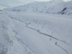
Scientists reported massive avalanches, including one that crossed a 1.5-mile-wide glacial valley and then flowed up the slope of the next mountain.
Patricia A. Craw of Alaska’s Department of Natural Resources in Fairbanks describes places as looking “like the snow pack had exploded off the mountainsides.”
The quake also cracked glaciers in two along the fault, a phenomenon not observed since the Lituya Bay earthquake in 1958. “It’s very surprising how clearly you can see the fault trace as it cuts up glaciers,” says Peter J. Haeussler of the U.S. Geological Survey in Anchorage.
The quake provided information hinting that two remote, poorly studied Alaskan fault systems may align with the San Andreas fault. The Nov. 3 event moved not only the Denali fault but also an ice-hidden portion of the nearby Totschunda fault. Geologists say that the recent temblor might have originated as a thrusting movement along the western Denali, then moved eastward as a slipping motion before turning southeasterly into the Totschunda.
The newly confirmed Denali-Totschunda connection has excited geologists because the visible parts of the Totschunda are in line with the larger Fairweather-Queen Charlotte fault system. This system is the northern continuation of the San Andreas fault.
The Denali fault’s movement also might confirm a motion previously detected with global positioning systems (GPSs). A huge wedged block of Earth’s crust in southern Alaska is rotating counterclockwise, grinding and colliding with other landmasses, Freymueller says.
Geologists are scrambling to install seismometers and portable GPS instruments in the still-trembling Denali area before winter kicks in. “We’re going to have an extremely rich data set,” promises Freymueller. “There’s a lot more to come.”
****************
If you have a comment on this article that you would like considered for publication in Science News, please send it to editors@sciencenews.org.


