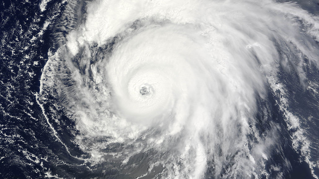
In August 2009, Hurricane Bill (shown) tracked northwest from Puerto Rico toward Newfoundland. As it passed offshore of New England, the winds churned up the ocean, which interacted with the seafloor to create stormquakes.
Jeff Schmaltz/MODIS Rapid Response Team/NASA Goddard Space Flight Center
Powerful hurricanes can whip the ocean into a frenzy — and that wave energy can be strong enough to hammer the seafloor, producing a novel kind of quake.
These stormquakes, as described online October 14 in Geophysical Research Letters, are a newly identified type of interaction between Earth’s atmosphere, ocean and crust. Unlike earthquakes, which are triggered by subsurface shifting within the solid Earth, the driving force behind these seismic signals are ocean waves that have been whipped into deep swells by a hurricane or nor’easter. Stormquakes can be as powerful as a magnitude 3.5 earthquake, a level barely noticeable to people but detectable by seismometers, seismologist Wenyuan Fan and colleagues report.
The work is “a really great first start” at understanding a little-studied part of the seismic record, says physical oceanographer Fabrice Ardhuin of the Ocean Physics and Satellite Oceanography laboratory in Brest, France. “It brings something really new.”
Scientists have long known that the constant sloshing of ocean waves produces seismic signals at frequencies of about once every few minutes, a phenomenon known as “Earth’s hum” (SN: 9/29/04). Waves can also produces high-frequency signals called microseisms, occurring every five seconds or so.
But in between that seismic noise is another band of signals generated in the ocean that occur once every 20 to 50 seconds or so, or at a frequency of between 0.02 and 0.05 hertz. What produces seismic signals within that band hasn’t been so well understood.
Initially, Fan, of Florida State University in Tallahassee, and his colleagues set out to look for possible triggers for these signals coming from within the Earth. They analyzed seismic data collected from 2006 to 2015 by a network of moveable seismometers that marched across the country from west to east as part of the USArray. Fan started out by focusing on the data from the Pacific Northwest. He became excited, he says, when he found what he thought were previously undetected offshore earthquakes occurring in that mysterious seismic band.
But then he noticed something weird about those data.
“They were seasonal,” Fan says; the signals occurred only during winter months. “Earthquakes do not have seasonality. But weather does.” The driving force behind the mysterious quakes came into clearer focus once he began looking at seismic data from the U.S. East Coast — prone to experiencing powerful storms such as hurricanes and winter nor’easters.
To be a stormquake, the team determined, the source of the seismic data had to meet several criteria. It had to occur during a stormy day; not be part of a known earthquake event; and belong to a swarm of similar quakes on the same day. In all, the team identified more than 14,000 stormquakes along the eastern coasts of Canada and the United States, as well as the U.S. Gulf Coast, from September 2006 to February 2015.
Oddly, not every powerful storm that pounded along that eastern seaboard produced stormquakes. Instead, stormquakes were confined to certain regions along the coast where seafloor topography maps indicated that there were small raised regions called ocean banks.
Hurricane Sandy, for example, produced no stormquakes as it roared toward land from off the coast of New Jersey in 2012. Off New Jersey, Fan says, the seafloor descends in a gentle grade along the continental shelf toward deeper ocean.
But storms such as 2009’s Hurricane Bill, which moved farther north and ultimately made landfall in Newfoundland as a tropical storm, triggered abundant stormquakes. That indicates that seafloor topography also plays a role in generating the quakes, Fan says. The team suggests that deep swells that form as storm-swept ocean waves interact and transfer energy may in turn interact with these elevated parts of the seafloor, essentially pounding at them like a hammer.
Potential uses for stormquake data are still coming into focus, Fan says. “It’s still very new. We didn’t know such things exist in nature,” he says. But, he adds, these seismic data originate in parts of the planet that are relatively tectonically inactive and therefore have been invisible seismically. That means that stormquakes may be able to “illuminate crustal structures in the continent that have never been lit up before.”
In addition to the U.S. East Coast, Fan notes, other parts of the world have the right kind of seafloor topography and storm activity to produce stormquakes, including the west coasts of Europe and India.
It’s interesting that the researchers were able to track the sources of some of the seismic signals back in time to the storms, says geophysicist Lucia Gualtieri of Stanford University. But, she says, large, moving storms impact a large portion of the seafloor. So it’s hard to see how those impacts might be considered to be point sources like the hypocenter of an earthquake – the location in the subsurface where a rupture takes place. “More work is likely needed to precisely understand the mechanisms behind these seismic records,” she says.
How big the “source” of a seismic signal is — whether a tiny slip of a fault line or an ocean swell hammering at an ocean bank hundreds of kilometers across — matters when it comes to using such signals to create high-resolution 3-D images of the seafloor, a technique called seismic tomography.
Ardhuin agrees that the size of the source of the signals remains an open question. “Is it still useful for tomography applications if the size of it is 100 or 400 kilometers?” he asks. But, he adds, in this case, it is possible that the shape of the seafloor in these locations might be creating an effective point source.
In other words, a very particular combination of hurricane, ocean waves and seafloor shape may be required to produce a perfect stormquake.


