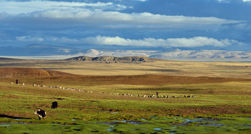
WINDSWEPT PLATEAU Today the central Tibetan Plateau, at an average of 4,500 meters above sea level, is known as the roof of the world. New fossil and geochemical studies suggest the uplift of the plateau may have happened more recently than once thought.
Tao Su
Plant fossils discovered in rocks from the Tibetan Plateau and a new analysis of the area’s geochemistry are rewriting the uplift history of the region dubbed the “roof of the world.” This new research suggests that the story of the rise to its current dizzying height is far more complicated than just raising the roof.
Previous research has suggested that the plateau reached its current height — about 4.5 kilometers above sea level, on average — by at least 40 million years ago. But chemical evidence left in the region’s rocks suggest that couldn’t have happened before about 40 million years ago, researchers report in the March 1 Science.
Meanwhile, another team of researchers suggests that, as recently as 25 million years ago, the region wasn’t yet a flat, windswept plateau. Instead, it was a diverse landscape of steep mountains surrounding a deep valley where palm trees grew, the team reports online March 6 in Science Advances.
The uplift of the Tibetan Plateau altered atmospheric patterns in the region, causing the onset of monsoons in South Asia as well as the drying out of Asia’s interior, says Svetlana Botsyun, a paleoclimatologist at the University of Tübingen in Germany. In fact, the plateau is so tall that it also affects the atmosphere around the globe, altering temperature, precipitation, humidity and cloud cover, Botsyun says.
Yet when exactly that all began to happen isn’t clear.
Traces of rain hold clues to elevation
About 55 million years ago, the Indian subcontinent rammed northward into the Asia plate, and the land between them buckled. The Himalaya mountain range was born, and the Tibetan Plateau north of the mountains was pushed upward.
Previous techniques to estimate changes in the region’s elevation over time have given varying answers on how long this took. One, called paleoaltimetry, uses oxygen isotopes, forms of the element with the same number of protons but different masses. At higher elevations, the ratio of oxygen-16 to oxygen-18 in rainfall is higher than it is at lower elevations. Previous analyses of the ratio of those isotopes preserved in the minerals of carbonate rocks, along with the dates of those rocks, have suggested the plateau must have been more than 4 kilometers high by at least 40 million years ago.
Another way to figure out the timeline is to use plant fossils from species with a limited range of temperature or altitude tolerance. That fossil evidence has tended to suggest the plateau was much lower 40 million years ago, Botsyun says.
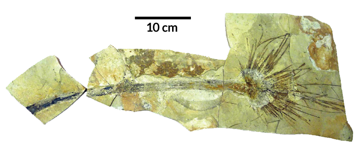
Fossil frond
The discovery of this fossilized palm frond in what’s now the central Tibetan Plateau suggests the region was neither as high nor as flat 25 million years ago as it is today. Based on the palm’s likely cold tolerance, researchers suggest the tree grew in a deep, ancient valley that was no higher than 2.3 kilometers above sea level at the time; the uplift to a flat plateau must have happened sometime after that, the researchers say.
In the new study, Botsyun and her colleagues called the previous paleoaltimetry estimates into question. Factors other than elevation can affect oxygen isotope ratios in rainfall, she notes. Changes in concentrations of atmospheric carbon dioxide and different sources of the water that becomes the precipitation can affect those ratios, throwing a wrench in the works.
Those factors were at play during the Eocene Epoch, about 56 million to 34 million years ago: The epoch was marked by much higher atmospheric CO₂ than today; a wide, shallow sea covered parts of what is now central China; and the Indian subcontinent wasn’t quite where it is now. All of those things may have altered the hydrologic cycle, and consequently the oxygen isotope ratios in the rain.
Botsyun and her team took these factors into account in a series of computer simulations to re-create atmospheric circulation during the Eocene, and then recalculated the oxygen isotope ratios. “We can’t tell when the uplift [did] happen,” Botsyun says, but her team’s results suggested that, by 40 million years ago, the plateau was still no higher than 3 kilometers above sea level.
Palm in a paleovalley
That the uplift happened later than once thought gels not only with past fossil evidence, but also with the new discovery of fossils of a kind of palm tree found in the central Tibetan Plateau. Paleobotanist Tao Su of the Chinese Academy of Sciences in Mengla and colleagues date the palm fossils to about 25 million years ago. Based on the ability of the plant’s living relatives — all tropical and subtropical species — to tolerate cold, the researchers concluded that, at the time, the region could not have been more than about 2.3 kilometers above sea level.
Su and colleagues also suggested that the region wasn’t a high, flat plateau at the time, either. Instead, the palm lived in a deep valley surrounded by high mountain ranges to the north and south, the team suggests. Their findings are based on computer simulations of past climate that varied the topography of the region and incorporated previous estimates of temperature based on leaf fossils at nearby sites.
What we think of as the Tibetan Plateau was actually a jigsaw of tectonic blocks of land, each with its own elevation history, notes Robert Spicer, a coauthor on the palm fossil study. That history began around 200 million years ago, during a previous tectonic collision with the Asian plate. By the time the Indian subcontinent began its collision, parts of what is now the plateau were already as high as 4.5 kilometers above sea level, says Spicer, an earth scientist at the Open University in Milton Keynes, England.
The valley in which the palm lived existed from about 60 million to at least 20 million years ago, Spicer says, and contains many more fossil finds “much older than the palms.” Those fossils suggest the valley floor was home to a fascinating, diverse subtropical ecosystem. But as the collision of the Indian plate with Asia continued, the land continued to rise, and sediment eroded from the mountain ranges eventually filled in the valley, forming a high flat plateau, he says.
The plant and isotope-derived elevations agree on a key point: that the central part of what’s now the Tibetan Plateau rose to its current height much later than once thought, Spicer says. But to really understand the history of the Tibetan Plateau, the paleoaltimetry method needs to incorporate the geologic history of the region, he adds. “You need to get the topography right. If you have the wrong Tibetan geometry, you cannot produce realistic results.”
Botsyun doesn’t disagree. “Based on our current research, we were able to reconcile existing paleoaltimetry data and paleobotanic evidence,” she says. But adding in a deep valley landscape to her simulations “would be really interesting.”


