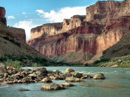
Studies of mineral formations found in caves in the walls of the Grand Canyon and nearby may provide fresh insight into the chasm’s history, including its age and the rate at which it was carved.
Many of these caves contain mammillaries, mound-shaped lumps of carbonate minerals that typically form just below the surface of mineral-rich pools. Thus such deposits mark the level of the local water table, says Carol Hill, a geologist at the University of New Mexico in Albuquerque. If the water table drops—due, say, to changes in climate or tectonic movements of Earth’s crust—the formation will be left high and dry. By measuring the concentrations of uranium and lead in a deposit’s outer layers, researchers can estimate when its pool dried up.
Hill and her colleagues analyzed mammillary formations from nine caves near the Grand Canyon. Most of the caves lie within a few kilometers of the Colorado River, the waterway that now flows through the chasm. Also, the deposits that the researchers sampled came from elevations no more than 1.2 km above the modern river level, says Hill. The researchers presume that ancient changes in the region’s water table are linked to drops in the river level as it scoured deeper into the region’s rocks.
Analyses of one mammillary from the western Grand Canyon region suggest that when the deposit stopped growing some 17 million years ago, the water table stood about 1,160 meters above today’s river level. Other analyses from that region indicate that by 7.6 million years ago, the water table had dropped to 930 m above the modern river level. About 2 million years ago, the water table was only 120 m higher than it is now, leading researchers to infer that during that interval the Colorado has scoured the western reaches of the canyon downward by that amount. Overall, rates of downward erosion in this region have averaged between 55 and 123 m per million years during the past 17 million years, Hill and her colleagues report in the March 7 Science.
Analyses of cave mammillaries in the eastern Grand Canyon region suggest that the Colorado’s downward scouring there began much later but has occurred at dramatically faster rates. In that area, the water table—and, presumably, the river level—has dropped about 920 m in the past 3.7 million years, at average rates between 166 and 411 m per million years.
Together, the cave-formation data suggest that erosion of the Grand Canyon began at its western end and proceeded upstream, says Hill.
Hill and her team “have compiled an excellent record of local water tables dropping” but their assumptions about the region’s geology may be incorrect, says Joel L. Pederson, a geomorphologist at Utah State University in Logan. Water tables aren’t always flat over large regions of complicated topography, he notes. Moreover, decreases in the water table inferred for the oldest of the cave formations might have been linked to the carving of canyons that predate the Grand Canyon.