The above-average number of major hurricanes in the North Atlantic during the past 6 years may signal a weather trend that could threaten Central America, the Caribbean, and the eastern United States for decades to come.
Hurricane activity in the Atlantic Ocean north of the equator was generally quiet between 1971 and 1994, says Stanley B. Goldenberg, a meteorologist at NOAA’s Hurricane Research Division in Miami. Then, between 1995 and 2000, the overall annual hurricane activity doubled. Activity is a measure that includes the number, duration, and strength of storms. More disturbingly, the proportion of the storms that grew into major hurricanes—those with wind speeds greater than 112 miles per hour—was higher in those years than in the previous quiet spell.
The recent spate of North Atlantic hurricanes may be more than a stretch of bad luck; it could be a preview of coming events.
Goldenberg and his colleagues report in the July 20 Science that the frequency and intensity of hurricanes in the region seem to follow a pattern. The trends observed in the past 30 years echo those seen early in the century. A quiet period with relatively few major hurricanes stretched from the 1900s to the mid-1920s and then was followed by more intense activity that lasted through the 1960s.
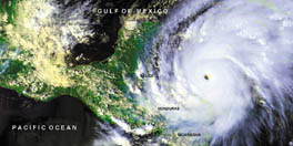
More specifically, the team found that the long-term variation in North Atlantic hurricane activity generally follows sea and climate conditions between the latitudes of 10°N and 20°N, where most such storms begin to form. The higher the average sea-surface temperature there rises above 27°C, the more often atmospheric low-pressure areas develop into hurricanes. The western edge of this band of ocean stretches from the northern coast of South America to Cuba’s southern tip.
Also, when vertical wind shear—the difference in speed and direction between low- and high-altitude winds—is great, those low-pressure areas don’t tend to develop into hurricanes. That’s because strong wind shear usually rips the tops off clouds in a gathering storm before they can gain strength and coalesce, Goldenberg says.
Lennart Bengtsson, a meteorologist at the Max Planck Institute for Meteorology in Hamburg, Germany, notes that there’s only about 60 years of what he considers reliable hurricane observations in the North Atlantic. That’s not nearly enough data to determine either long-term trends or short-term variations in hurricane activity, he contends in a commentary also appearing in the July 20 Science.
Goldenberg disagrees. He notes that even though reliable records for storms at sea extend only to 1944, when scientists began to routinely monitor them with aircraft, good records of hurricane landfalls stretch back to the early 1900s. Measurements of ocean temperatures in the region date back even further, to the 1870s.
If Goldenberg’s analysis is correct, meteorological data over the past 6 years mark a clear shift toward more frequent and stronger hurricanes in the North Atlantic and Caribbean. Goldenberg warns that such a pattern could last for another 10 to 40 years.


