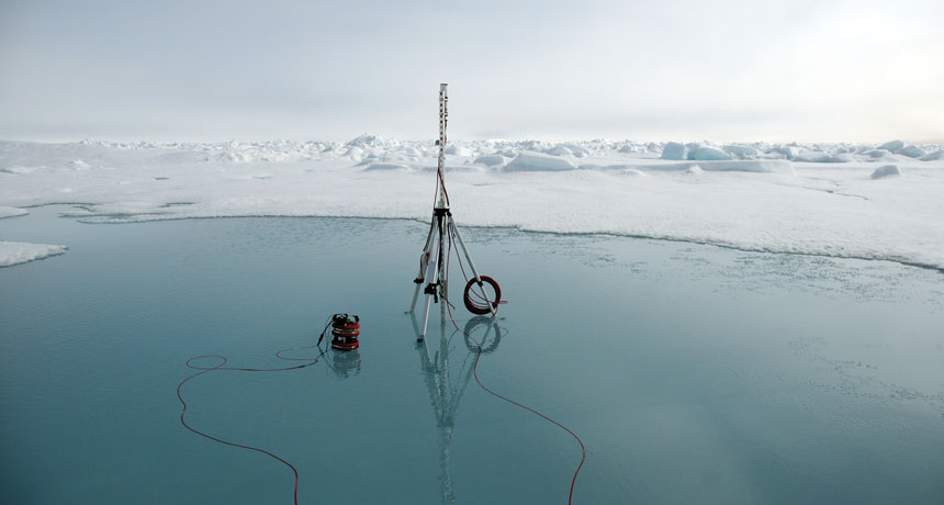
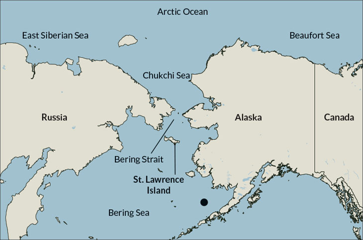
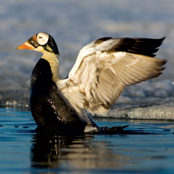
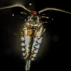
MISSING ICE Cameras, like this one, set up in the Chukchi and Bering seas, record how much light reaches through the melt ponds that sit atop sea ice. More light means more algal blooms grow below the surface.
K. Frey
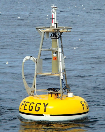
Peggy’s data were a bit of a shock.
From an anchored vantage point in an expanse of the southeastern Bering Sea west of Alaska, Peggy, or mooring M2, had monitored conditions in the water for 25 years. A line of sensors extended down more than 70 meters to where Peggy was tethered to the seafloor, collecting information on temperature, salinity and other properties of the water.
Most years, the waxing and waning of floating sea ice follows a consistent seasonal pattern that is reflected in Peggy’s data. By November, sea ice migrates in through the Bering Strait or forms in some parts of the Bering Sea. As a by-product of the sea ice formation, a large mass of cold, salty water begins to pool near the seafloor. In the spring, phytoplankton bloom, and by early summer, the sea ice begins to melt away. The cold pool, however, lingers through the summer.
With an average temperature just below zero degrees Celsius — a few degrees colder than the surrounding water — that deep, cold pool is central to the Bering Sea ecosystem. The cold pool is where Arctic cod take refuge, hiding from predators such as Pacific cod and pollock, which are less tolerant of the cold. The Arctic cod get fat on large, shrimp-like copepods and spawn their young. In turn, the fish keep polar bears and seals well-fed.
But in the winter of 2017–2018, the sea ice never appeared. And Peggy’s data, along with that of other moorings, revealed that the cold pool was AWOL too. Alarm trickled through the ocean science community, researchers who study everything from the physics of the Bering Sea to the small creatures that live on the seafloor and the larger marine mammals at the top of the food chain. In December in Washington, D.C., at the American Geophysical Union’s annual meeting, these researchers gathered to present their data, trade stories and ponder what it all means.
Were these findings a fluke? “We don’t yet have enough data” to say whether the Bering Sea is increasingly likely to be ice-free, says Jacqueline Grebmeier, a biological oceanographer at the University of Maryland’s Center for Environmental Science in Solomons. But Grebmeier, who has studied seafloor life in the Arctic for more than 30 years, has “a gut feeling,” she says, that it’s not a one-off incident. “I think it’s the beginning of change.”
If last year’s events represent a new normal for the Bering Sea (and the very low sea ice extent as of February this year signals they might), then a cascade of changes are in store for the complicated ecosystem that has long thrived in those waters — and for the fishing and tourism industries that rely on the area’s bounty.
Open waters
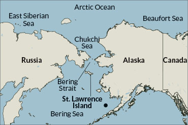
At their closest point, Alaska and Russia are separated by the 82-kilometer-wide Bering Strait. To the north of the strait lies the Chukchi Sea, on the edge of the Arctic Ocean; to the south is the Bering Sea, extending down to Alaska’s outflung arm of islands, the Aleutians.
In the summer, the Bering Sea is largely ice-free, but in winter, ice forms in the northern Bering Sea, or migrates southward through the strait from the Chukchi. The waters reach “freeze-up” when there is at least 20 percent ice cover, scientists say.
There were early signs that conditions in 2017 and 2018 were going to be different. By November 2017, the sea ice was already late. The air above the waves wasn’t especially warm. In fact, the air temperature was typical for that time of year, Phyllis Stabeno, a physical oceanographer at the National Oceanic and Atmospheric Administration’s Pacific Marine Environmental Laboratory in Seattle, reported at the December meeting. But an unusually persistent wind was blowing from the south, she said, preventing the ice from drifting down from the Chukchi Sea as it would normally.
The wind tapered off by December and January, but by then air temperatures were higher than normal. The Chukchi Sea, normally at least 80 percent covered by thick, tough, icebreaker-testing pack ice by January, still had large open swaths of water. That meant less ice was available to migrate southward through the Bering Strait.
Deep warming
Temperatures near the seafloor in the northern Bering Sea tend to hover around −1.5° Celsius in July, forming a “cold pool.” But in 2018, the average bottom water temperature was about 1.5°, signaling the absence of a cold pool that year. No data were collected in July 2009.
Summer temperatures near the northern Bering Sea floor
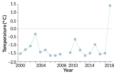
Mooring M8, about 800 kilometers northwest of Peggy, had never recorded so little ice in the winter. M8, taking measurements since 2008, registered temperatures just above the seafloor that were more than 3 degrees C above normal. And Peggy, down by the Aleutians, had never recorded higher summertime water temperatures near the seafloor. That summer, the water never dropped below freezing.
Then, in February, the strong southerly winds began again, and the unusual wind direction persisted through March; scientists suspect those winds kept the Chukchi Sea unusually warm, by pushing warmer waters from the Bering Sea northward. The warmer waters also prevented the formation of sea ice. The ice that did form in the Chukchi and Bering seas was thin and easily pushed back northward by the prevailing winds.
Sea ice, whether migrating in or forming in place, is an anchoring part of the Bering Sea ecosystem. The ice helps determine when and where food becomes available to creatures living in the water or on the seafloor. As the migrating sea ice travels south, it melts. That meltwater is relatively fresh and less dense than the surrounding water. As a result, the waters become stratified, with the layer of fresher water staying on top. That freshwater, full of nutrients, helps give rise to the southern Bering Sea’s springtime phytoplankton blooms, which in turn feed copepods and other small floating creatures. When the phytoplankton eventually die and sink to the seafloor, they provide an important food source for creatures living on the bottom.
But the absence of sea ice means that the water doesn’t stratify until later in the spring, and so the phytoplankton blooms happen later in the spring. Not every Bering Sea dweller will be quick to adjust to those delays in the ecosystem’s food web.
“The timing is important,” Grebmeier says. “It’s a question of how fast [the animals] can adapt.”
And thanks to the winds and warmth, little sea ice managed to form within the Bering Sea, which meant no deep, cold pool near the seafloor. Normally, the cold pool forms as a by-product of sea ice formation, especially in a region just south of St. Lawrence Island. Prevailing winds blowing south from the island create a space of open water called a polynya that freezes quickly in winter. As quickly as the ice forms, the winds blow it away from the island, opening up the water again to more freezing, creating a sea ice production line. All of that ice forming at that one spot pulls a lot of freshwater out of the sea; the water that’s left behind is salty and dense and sinks down to the seafloor, forming that pond of cold water that lingers throughout the summer.
Arctic in transition
Although the dramatic absence of sea ice last winter was startling, waters in the Arctic have actually been on a decades-long warming trend. In the southern Chukchi Sea, freeze-up has happened about half a day later each year since 1981, Stabeno and colleagues reported in November in Deep-Sea Research. And in the northern Bering Sea, mooring M8’s data show particularly stark changes over the last four years. From 1981 to 2014, freeze-up happened on average by the end of December. But since 2014, freeze-up hasn’t occurred until January or February — or, in 2018, not at all.

This warming trend has had trickle-down effects on the seafloor dwellers. Species such as bivalves that once carpeted the seafloor surrounding St. Lawrence Island, to the south of the strait, have shifted northward, Grebmeier says.
In 2010, Grebmeier helped establish the Distributed Biological Observatory, an international effort to monitor long-term ecosystem changes in the Arctic by visiting designated “hot spots” year after year in the region, including the Bering and Chukchi seas. Those sites include the region just south of St. Lawrence Island, where the cold pool usually forms.
Bivalves on the seafloor there used to provide a nutritious, fatty food for walruses and seals. And spectacled eiders — a kind of sea duck — dove for the mollusks, using the sea ice as a safe, stable launch pad. But over time, those bivalve patches have given way to marine worms, a far less nourishing food, Grebmeier says. For spectacled eiders, which are considered at risk of extinction in the near future, the food shift and the loss of sea ice is a one-two punch. “It takes less energy to sit on the ice and feed on underlying prey than to swim,” she says. “So the impact on these organisms is dramatic.”
Other creatures in the Arctic have taken a hit as well. Researchers have measured an increase in the populations of small copepods that tiny larval pollock eat. But populations of fattier and more nourishing large copepods are in decline, which is bad news for juvenile fish that need the larger copepods to survive through the winter.
The prey changes have had cascading impacts on the food web: Changes in the distribution and types of fish populations have spelled doom for thousands of seabirds. Last summer was the third year in a row with a massive seabird die-off, Calvin Mordy, a biological oceanographer with NOAA’s Pacific Marine Environmental Laboratory, reported at the December meeting. The seabirds showed evidence of starvation, he said, not disease.
Ups and downs
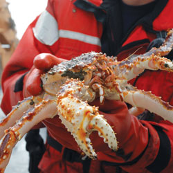
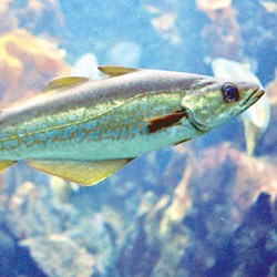
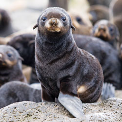
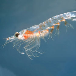
2018’s record-setting low sea ice in the northern Bering Sea and a missing cold pool in the southern Bering took a toll on some species. Blue king crabs, ribbon seals and krill have decreased. Small copepods and urchins fared better.
| Species decreasing | |||
 |
 |
 |
 |
| Spectacled eider | Pacific cod | Ribbon seal | Thick billed murre |
 |
 |
 |
 |
| Blue king crab | Pollock | Northern fur seal | Krill |
| Species increasing | |||
 |
 |
||
| Small copepod | Urchin | ||
| Species decreasing | |||
|
|
|
|
| Spectacled eider | Pacific cod | Ribbon seal | |
|
|
|
|
| Thick billed murre | Blue king crab | Pollock | |
|
|
||
| Northern fur seal | Krill | ||
| Species increasing | |||
|
|
||
| Small copepod | Urchin | ||
The heat is on
The combination of wind and warmth that led to the record-low sea ice in the Bering Sea, scientists say, was unusual based on past records. The question is how typical these conditions will be in the future, Stabeno says.
The Arctic is warming twice as fast as the rest of the planet, with an average temperature about 1.7 degrees C above the long-term average during 1981 to 2000, according to the 2018 Arctic Report Card, NOAA’s annual report on the state of the Arctic. In fact, the five years since 2014 are the five warmest scientists have ever measured, says Emily Osborne, the lead editor of the 2018 report card and a climate scientist with NOAA’s Arctic Research Program in Silver Spring, Md. Last year was the second-warmest year on record, exceeded only by 2016, she says. One visible effect of the temperature rise is a sharp decline in summer sea ice cover, with the last 12 years being the 12 lowest on record.
Rising air and ocean temperatures aren’t the only sign of change in the Arctic Ocean. The runoff from local rivers is having an impact. “It’s the most land-dominated ocean in the world,” says Karen Frey, a polar scientist at Clark University in Worcester, Mass. “It’s a dumping ground for everything,” she adds, from sediment loads carried by rivers to dissolved organic matter to phytoplankton. “All roads lead to the Arctic.”
In 2018, the volume of discharge of the eight largest rivers emptying into the Arctic Ocean was about 20 percent higher than it was in the 1980s, due to some combination of factors related to global warming, including increasing degradation of permafrost and increasing rainfall in the High Arctic.
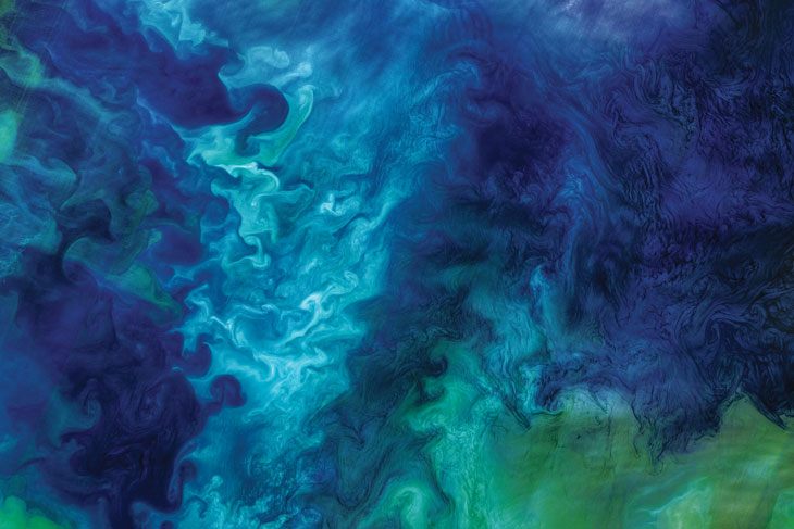
All of that material pouring into the ocean has resulted in a heightened supply of nutrients. The extra nutrients plus the warmer waters and more sunlight shining through — thanks to the missing or thinner sea ice — add up to larger phytoplankton blooms, Frey says. Some of that algal biomass — scientists don’t yet know how much — is toxic, akin to the deadly red tides blossoming along Florida’s coasts in recent years (SN: 9/29/18, p. 14). Such toxins can kill fish, as well as produce neurological damage in humans.
Paralytic shellfish poisoning has increased seven-fold among Alaskans over the last 40 years, with the rise possibly caused by an increase in harmful algal blooms, Frey says. The state now has one of the highest incidences of shellfish poisoning in the world. The frequency and distribution of harmful algal blooms have both increased dramatically in recent years, prompting the first special section on harmful algal blooms included in the 2018 Arctic Report Card.
The culprit algae may have “been present in many areas at low levels that wouldn’t be harmful. But the minute you start warming seawater … and removing sea ice, they adjust,” Frey says. “We are just starting to make measurements of harmful algal blooms and starting to understand how those species in the Arctic respond to light. It’s a very new question that has yet to be answered.”
Frey, as part of the Distributed Biological Observatory program, visited the Bering Sea last July to measure how less sea ice, as well as thinner sea ice, changes the amount of light that reaches the waters to encourage blooms. Even the thinner ice — often covered with small melt ponds — could have a big effect on how much light penetrates, she found.
The melt ponds “are basically skylights” for the waters below, she says. Having melt ponds on the surface of the sea ice can increase transmission of light into the water from perhaps 10 percent to as much as 60 or even 70 percent, Frey reported at the December meeting.
The increase in phytoplankton blooms was particularly dramatic in 2018, the report card notes. Less sea ice and more melt ponds meant more light penetrated the Arctic’s waters earlier in the year, prompting blooms in the northern Bering Sea even as the south bloomed later. The northern waters, which normally see blooms in May, bloomed as early as March. The amount of algal biomass in March was about 275 percent higher than the average March biomass for 2003 to 2017.
Scientists are still studying how much the harmful algal blooms may have contributed to excess seabird deaths. Bloom-related toxins have been implicated in other wildlife mass mortality events in the last few years, from walrus to seals to whales — animals that probably ate contaminated fish and shellfish, just like humans, the Arctic Report Card notes. As warming waters and decreasing ice cover create ever more favorable conditions for all algal blooms, the threat of harmful toxins will almost certainly contribute to economic losses for two of the region’s biggest industries: fishing and tourism.
“Historically we shouldn’t be seeing another year like [2018], but under that argument, this year shouldn’t have happened,” Stabeno said in December. “What we saw this year was predicted to happen in 2050,” she added. “This gives us a view of the future.”