When a set of instruments monitoring an underwater volcano got trapped in an eruption in early 1998, the scientists who had deployed the sensors ended up with considerably more data than they bargained for.
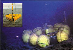
The sensors were deployed on the ocean bottom in October 1997 to monitor the slow heavings of Axial volcano, which breaches the Juan de Fuca undersea ridge and rises to an ocean depth of 1,500 meters about 400 kilometers off the coast of Oregon. By measuring the water pressure every 15 seconds, scientists could monitor long-term changes in ocean depth and thereby the rise and fall of the volcano’s summit, says Christopher G. Fox, a marine geophysicist at NOAA’s Pacific Marine Environmental Laboratory in Newport, Ore.
But in January 1998, the instruments were caught in an unforeseen submarine eruption (SN: 2/28/98, p. 133). As chance–and physics–would have it, the sensors survived.
As the 1,200C lava spilled from the undersea ridge, it spread in a thin layer beneath the sensors, which were mounted on a stand about 0.5 meter above the ocean floor. The water, 2C or so at that depth, immediately chilled the surface of the lava into a thin, hard veneer that trapped the instruments yet insulated them from the molten rock still flowing beneath the newly cured layer. Temperatures just a few centimeters above the lava never reached more than 7.5C, says Fox.
For about 2 hours, the package of instruments–which the researchers dubbed a rumbleometer–rafted atop the lava’s hardened surface in response to the eruption’s ebb and flow. In the first 72 minutes of the volcano’s eruption, the sensors indicated that the lava rose about 3.5 m. Then over the next 81 minutes, the rumbleometer chronicled a drop of about 2.5 m as the molten lava flowed away and left the structure to deflate “like a soufflé collapsing,” notes Fox. He and his colleagues report their sensors’ wild ride in the Aug. 16 Nature.
Even though undersea volcanic eruptions are commonplace, no one had ever seen one in progress, says Jonathan Fink, a volcanologist at Arizona State University in Tempe. “Having these instruments there at just the right time was a remarkable accident,” he notes.
“You could never design an experiment that could do this
intentionally–and even if you could, you’d probably never get it funded,” agrees H. Paul Johnson, an oceanographer at the University of Washington in Seattle.
The seafloor off the Pacific Northwest coast is one of the most heavily instrumented areas of ocean bottom, says Fox. It’s close to several ports, and there’s also a network of military sensors established during the Cold War that scientists now use to monitor underwater seismic activity and whale migrations.
Still, he admits, it was “incredible luck” that his research team’s instruments were in the right place at the right time and had a design that could survive a lava flow and still collect data.
Scientists plan to use the detailed characteristics of Axial volcano’s 1998 eruption, including the flow rate and the volume of the lava that was generated, to refine their models of submarine volcanic activity and verify laboratory simulations. These models, in turn, will guide researchers as they design the next generation of seafloor instruments, Fox notes.