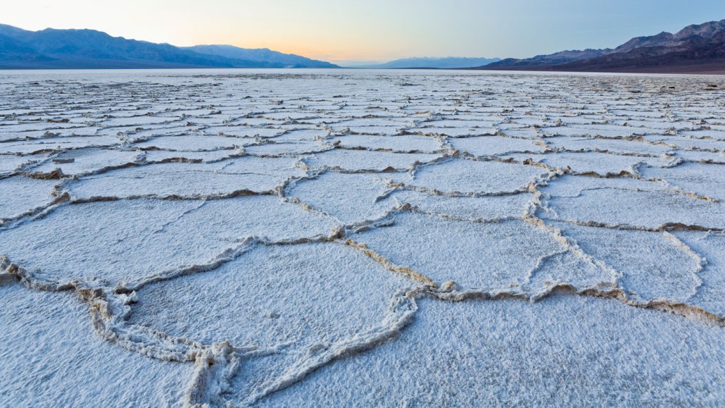
Salt flats around the world — such as these in Badwater Basin in Death Valley, Calif. — form polygons of similar size.
Rudy Sulgan/The Image Bank/Getty Images Plus
- More than 2 years ago
From Death Valley to Chile to Iran, similarly sized polygons of salt form in playas all over the world — and subterranean fluid flows might be the key to solving the long-standing puzzle of why.
Geometric shapes such as pentagons and hexagons spontaneously form in a wide range of geologic settings. Dried mud, ice and rock often crack into polygons, but these patterns tend to vary dramatically in size.
So why are all playas so persistently similar? The answer lies underground, physicist Jana Lasser and colleagues propose February 24 in Physical Review X. With sophisticated mathematical models, computer simulations and experiments performed at Owens Lake in California, the team connected what they saw on the surface with what is going on beneath.
“Fluid flows and convection underground are uniquely able to explain why the patterns form,” says Lasser, of the Graz University of Technology in Austria.
This 3-D approach was key to explaining the universality of salty polygons.
Salt flats form in places where rainfall is scarce and there’s a lot of evaporation (SN: 12/5/07). Groundwater seeping up to the surface evaporates, leaving a crust of salts and other minerals that had been dissolved in the water. Most striking, this process results in low ridges of concentrated salt that divide the playa into polygons: mostly hexagons with a smattering of pentagons and other geometric shapes.
The type of salt varies from one playa to another. Table salt, or sodium chloride, dominates in some playas, but others have more sulfite salts. And the salt crusts themselves range in thickness from a few millimeters to several meters. That variation seems to be why previous attempts to describe the playas’ patterns failed.
Whether the crusts are meter- or millimeter-thick, salt pans feature polygons that are 1 to 2 meters across. Previous models based on cracking, expansion and other phenomena that describe how mud and rock fracture instead produce polygons with sizes that vary according to crust thickness.
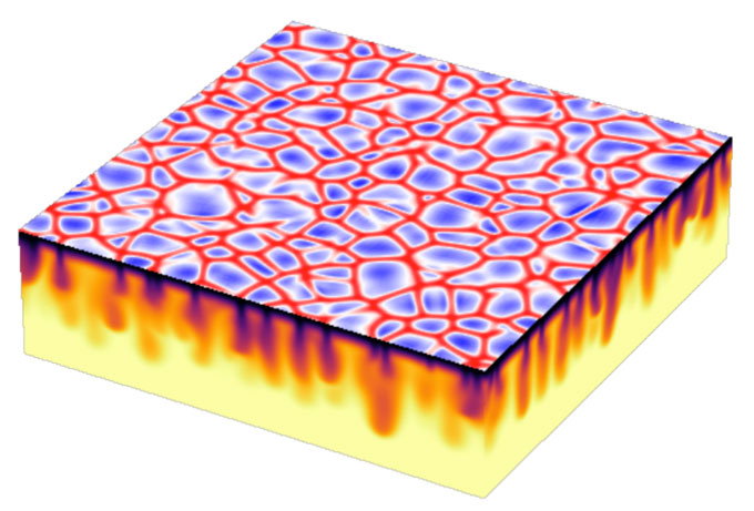
As groundwater evaporates from the surface, it concentrates salt in the remaining groundwater. That salty water, now denser and heavier, sinks, forcing other less dense water upward. Lasser and colleagues showed that over time, the circulation, known as convection, tends to push the descending plumes of saltier water into a network of vertical sheets. The surface above these sheets accrues more salt, so thick salt ridges grow there. Thinner crusts of salt form between, where less salty water upwells, spontaneously making the characteristic polygons shared by playas around the world.

The equations the researchers used describe the relative salinity of the groundwater, the pressure within the fluid and the speed at which the water circulates. Computer simulations that embraced the full complexity of the 3-D problem started with no salt crust or polygons and produced something that looks very much like real playas.
“This fluid dynamical model makes much more sense than a model that ignores what’s happening beneath the surface,” says physicist Julyan Cartwright of the Spanish National Research Council, who is based in Granada and was not involved in the research.
Tests at Owens Lake helped the team verify and refine the model. “Physics is so much more than just sitting in front of a computer,” Lasser says, “and I wanted to do something that involves experiments.”
The lake dried up in the 1920s as water was diverted to Los Angeles. The deposited minerals on the remaining salt flat include large natural concentrations of arsenic, which blows away with the dust kicked up by wind — creating serious health hazards. Among other remediation efforts, brine has been pumped onto the lake bed to try to create a more stable salt crust (SN: 11/28/01). That human intervention gave the researchers the opportunity to test their ideas in a controlled way.
“The whole area is destroyed,” Lasser says, “but for us it was the perfect research environment.”


