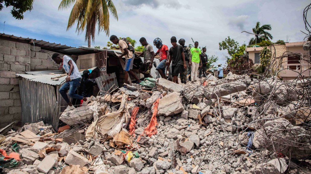
The magnitude 7.2 earthquake that struck Haiti on August 14 has killed at least 1,900 people and caused widespread damage in the country’s southern peninsula, including in Les Cayes (shown).
Richard Pierrin/Getty Images
On August 14, a powerful magnitude 7.2 earthquake struck Haiti, triggering landslides, toppling buildings and killing at least 1,900 people, with over 9,000 people injured. Rescue workers are racing against time to find survivors in the rubble, hampered by heavy rains from Tropical Storm Grace that battered and flooded the country’s southern peninsula on August 16.
Scientists, too, are rushing to the region to learn what they can from the devastation the quake left behind, in hopes of gaining a better understanding of the seismic hazards faced by the country.
The epicenter of the quake was near Petit Trou de Nippes, a town on Haiti’s southern peninsula about 125 kilometers west of Port-au-Prince. The Enriquillo-Plantain Garden fault zone passes straight through that peninsula, marking where the Caribbean tectonic plate to the south grinds against the small Gonâve tectonic plate to the north. Scientists often eye this fault zone as the likely source when a deadly quake strikes Haiti, such as the 2010 earthquake that killed at least 200,000 people (SN: 1/16/10).
But several months after that quake, scientists discovered that its origin was on a previously unknown fault, near but not part of the well-known Enriquillo zone (SN: 8/11/10). The fault was within a region of faults not mapped before, in part due to a dearth of seismometers in Haiti. Since then, researchers have worked to increase seismic measurements and understanding of the country’s seismic hazards, including through the creation of a network of volunteer “citizen seismologists.” Data collected by those volunteers have already proved invaluable to tracking the most recent quake and its aftershocks, says geologist Dominique Boisson of the University of Haiti in Port-au-Prince.
Science News talked with Boisson and geophysicist Eric Calais of the École Normale Supérieure in Paris about what we know about the new earthquake, scientists’ rapid-response efforts to map its impacts and how citizen seismologists can help. The conversation has been edited for clarity and brevity.
SN: What do we know about where exactly this earthquake occurred?
Boisson: Just after an earthquake, we have preliminary results that give you a sense of where the epicenter was. But we don’t have precise information — was it on this fault or another fault? That’s why we are doing the measurements we are doing right now.
Calais: We should keep in mind what happened in 2010. Right after the earthquake, it was the same thing: The Enriquillo fault is the main feature there, it’s got to be that fault. Then the data started coming in, and it became more and more clear that it was not that fault that had ruptured. And in the end, it was demonstrated that it was a small, secondary fault nearby. From a geologic standpoint, that’s very common. A good example is the 1989 Loma Prieta earthquake [in California] — that was not caused by the San Andreas Fault, it was triggered by a fault right next to it (SN: 4/21/90).
So are we in this situation from the earthquake of last week? The jury is still out. [This quake] seems to be shallower than the 2010 earthquake, and there’s a gap of about 50 kilometers between [where that quake and the August 14 quake occurred].
A question that a lot of seismologists have is what about this gap — will there be an earthquake [there]? Well, probably, but when, we don’t know. But it’s going to be an area of intense research in future years.
SN: What can we learn from the just-launched seismology fieldwork that researchers at the University of Haiti are doing?
Calais: It’s essential after any earthquake anywhere to be able to go to the field as quickly as possible to make a scientific assessment, of course without putting the emergency response into any difficulty. What it involves in practice is sending people to the field with instruments like seismometers and geodetic instruments [such as GPS receivers that can provide 3-D coordinates].
Boisson: Right now, with GPS, they are going to make a survey of the position of the ground, and where it was displaced. We are going to compare these measurements with measurements [from these areas] in the past, and we will track how this movement evolves in the next weeks and months. [We’re] also sending in teams to study landslides [triggered by the quake]. So there is a lot of work to do right now.
Calais: In the case of this earthquake, it’s particularly difficult to reach the field, but we are glad to be able to report that two of the researchers are safe in the field … [and] are deploying instruments to better understand the mechanism of the earthquake. That will be very important to assess what might be coming next, and in particular to better understand what the aftershocks are telling us.
SN: How well are the faults of this area mapped? And how might measurements of microseisms — abundant tiny earthquakes difficult to distinguish from background noise — help to image Haiti’s subsurface?
Boisson: The big [Enriquillo] fault is well-known. But we are very far from having detailed maps of the active faults of the southern peninsula or other parts of the country. There’s a lot of work to be done to have a good map of the active faults and what is the real shape of the structures underneath.
With data on microseisms, including from citizen seismologists, it will be very helpful to get this kind of information for imaging the structures in the subsurface (SN: 4/18/19). Even though the data [from the citizen seismologists] is not of the same quality as the professional networks, it’s very important for helping to image the structures.
SN: How important has the citizen seismology project been to tracking the recent earthquake and its aftershocks?
Calais: It has been essential. It’s just amazing how proactive the seismic station hosts have been. We call them hosts, because they host a tiny little box, about 10 centimeters by 5 centimeters by 5 centimeters. And you just connect it to power and the internet, and it provides data in real time. And then we have built a system that analyzes the data in real time and provides aftershock locations. So within 30 seconds of an aftershock, we know exactly where it happened, what was the magnitude and the depth and so on.
SN: How many citizen seismologists are working with you?
Calais: We have 15 stations throughout the country, and in the epicenter area, we have six stations. And we’re deploying more as we speak. We have a new project that’s just been approved to augment the network with an additional 50 stations.
SN: So who are these volunteers? What are some of the challenges they face in doing this work?
Calais: Their backgrounds vary — we have a public notary, we have a hotel owner, we have a civil engineer. It’s all over the map really. It’s not easy to have internet and power available all the time in Haiti — there’s no place, almost, where that’s possible. So everybody has a power generator of some kind; you buy your internet plan by the day. We had one station, the station closest to the epicenter … the host was so sorry because he had not renewed his internet plan when the earthquake happened. And right away he contacted us and said, “Well, I just ran to the internet provider and I just bought a new plan!” And his station came back online right away.
So it’s an amazing effort. It shows that there is really an interesting bridge to build between citizens who want to participate and want to be informed, and scientists. The data are very, very useful to us, and the interaction we’re having with the hosts is teaching us a lot also about how the risk is perceived and what kind of message [about potential seismic hazards] is useful.
The message of a seismologist is a very technical one, and so how do we convey a message that is actionable, that makes sense to the people who receive it? We’re not trained for that, and we need to learn from our audience what they need.
SN: In 2020, you (Calais and Boisson) and your colleagues published a preliminary report on the citizen seismology project, calling it a socio-seismology experiment. How might this work improve earthquake awareness and potentially reduce risks from these hazards?
Calais: It’s a very interesting endeavor because it’s not only seismology that we’re interested in. It’s a project that we’re conducting with sociologists and anthropologists. The project is too young to be able to tell whether it has made any difference in the level of preparedness. But right now are we are trying to organize a team of sociologists to send into the field to interview people and build a baseline of information about how risk is perceived. We don’t have that. It’s a shame that we tend to send emergency response, seismologists and so on, [but] we don’t think so much about sending sociologists.
After the 2010 earthquake, which was really a dramatic experience for a lot of people, there was no baseline study that was done right after. So you come back 10 years later, and you can’t tell a difference between how the risk is perceived. So we’re trying to change that.


