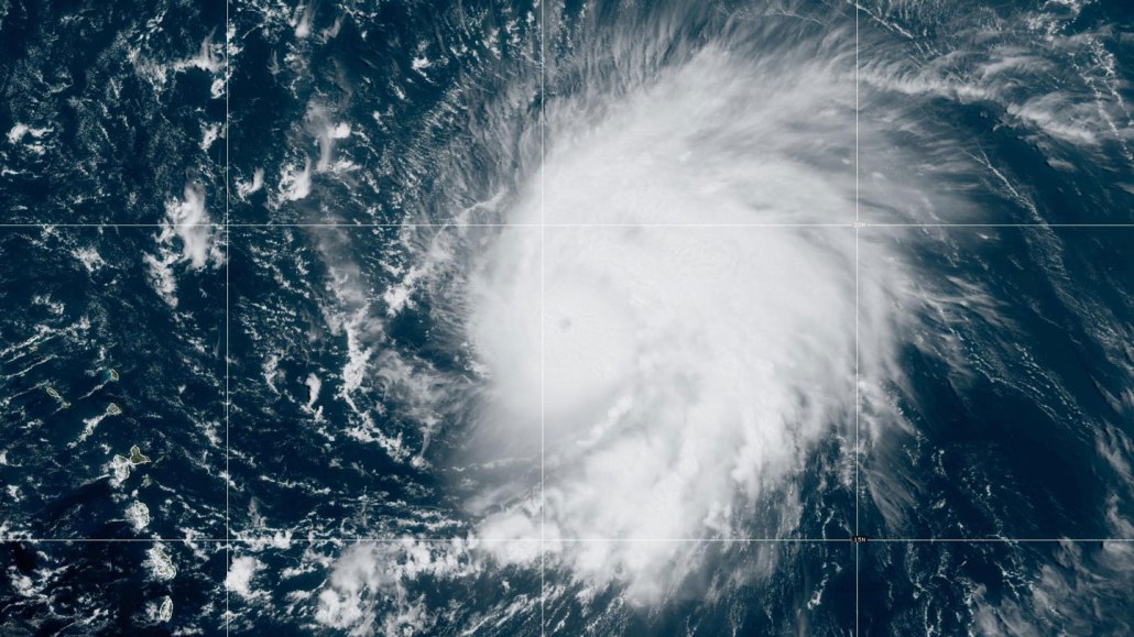
In just 24 hours, Hurricane Lee intensified explosively from a Category 1 to a major Category 5 hurricane (shown here as a Category 5 on September 8).
NOAA/NESDIS/STAR
- More than 2 years ago
Read another version of this article at Science News Explores
On the morning of September 5, a loosely swirling system of thunderstorms formed off the western coast of Africa. By September 6, the system had become a Category 1 storm, with maximum winds at least 130 kilometers per hour (80 miles per hour).
Just 24 hours later, fueled by the record-warm waters of the North Atlantic Ocean, Hurricane Lee whipped itself into a Category 5 monster. In that short time span, its wind speeds doubled, to 260 kilometers per hour (160 miles per hour).
As the world’s oceans continue to stockpile heat from global warming, stories of such rapid intensification of tropical cyclones are becoming more commonplace, and not just in the Atlantic.
“While all eyes are on [Hurricane Lee], [Hurricane Jova] is bombing out in the eastern Pacific,” wrote Miami-based U.S. National Hurricane Center meteorologist Eric Blake on X, formerly called Twitter, on September 6. “This was just named 36 hours ago and has exploded into a Category 4 hurricane.”
These storms formed just weeks after Hurricane Idalia, which also rapidly intensified. Its wind speeds cranked up from about 120 kph to 209 kph (or 75 mph to 130 mph) in 24 hours. Shortly afterward, Idalia slammed into Florida’s Gulf Coast.
All of these hurricanes easily met — and some greatly exceeded — the National Hurricane Center’s definition of rapid intensification, in which a storm’s maximum sustained winds jump by at least 56 kph (35 mph) in less than a day. Such storms can leave people little time to prepare, making the hurricanes particularly dangerous to lives and property.
Here ‘s what to know about such rapidly intensifying storms.
A warmer ocean and atmosphere can supercharge storms
The key ingredients to boost a storm’s power quickly are very warm ocean waters, a lot of moisture in the atmosphere and low vertical wind shear, says atmospheric scientist Philip Klotzbach of Colorado State University in Fort Collins (SN: 9/28/18; SN: 9/13/18).
Vertical wind shear is what happens when winds at different heights in the atmosphere are moving at different speeds and in different directions. Those winds can chip away at a storm as it tries to organize into a tight swirl by pulling heat and moisture away from the storm’s center and sweeping away the upper structure of the storm.
This year saw the onset of an El Niño phase of the El Niño-Southern Oscillation ocean-climate pattern, a phase that tends to bring more vertical wind shear conditions to the North Atlantic. That means that El Niño years tend to feature fewer Atlantic tropical storms (SN: 5/26/23).
But so far in 2023, El Niño hasn’t done much to minimize hurricane formation, or dampen the storms’ power. “The first half of the season has not seen the unfavorable upper-level wind conditions in the western Atlantic that are typically observed in an El Niño year,” says Ryan Truchelut, president and chief meteorologist of WeatherTiger, a weather consulting firm based in Tallahassee, Fla. That’s true even in the Caribbean Sea, where El Niño’s shearing power tends to be strongest, Truchelut adds.
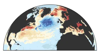
Generally, there’s more of a contrast in temperature between the Atlantic and Pacific ocean basins during an El Niño year — the weather pattern heats up the eastern tropical Pacific while the Atlantic stays relatively cool. But 2023 has seen record-breaking ocean temperatures in the North Atlantic Ocean and in the Gulf of Mexico (SN: 6/15/23). While the El Niño-warmed Pacific is about 1.5 degrees Celsius above normal, parts of the Atlantic are 1 to 3 degrees C above normal.
“Temperature contrasts drive jets,” Truchelut says, “and the lack of this contrast is likely responsible for the missing shear.”
The extremely warm waters of the Atlantic and the Gulf of Mexico set the stage — all the storms needed was a window of time with favorable wind conditions, says John Kaplan, a hurricane modeler with the U.S. National Oceanographic and Atmospheric Administration’s Atlantic Oceanographic and Meteorological Laboratory, based in Miami. “What it really comes down to is whether the conditions for rapid intensification are favorable for even a short period of time,” he says. “If there’s a window — even if not a very long one — the system can take advantage of it. That was the case for both Lee and Idalia.”
More storms are rapidly intensifying as Earth warms
It certainly feels like most of the hurricanes in recent years are rapidly intensifying (SN: 8/27/20). But is that a true trend? And if it is, is it linked to climate change?
Studies suggest that it’s not just anecdotal. In August, researchers reported that the yearly number of tropical storms around the globe that rapidly intensified just offshore (within 400 kilometers of land) increased by about three a decade over the last 40 years, from fewer than five per year in the 1980s to about 15 per year by 2020.
Open-ocean storms, spinning far out in the big blue, showed no discernible trend, the team found. But that’s perhaps not wholly reassuring, as it’s the storms closer to shore that are most threatening to coastal populations. And a 2021 study reported that tropical cyclones have been migrating closer to the coasts since 1982.
In 2019, another team focused on observational records of wind-speed changes over 24-hour increments. Based on those data, the researchers found that episodes of rapid intensification in tropical storms tripled from 1982 to 2009. Using climate simulations, the team researchers determined that the rapid intensification trend was strongly linked to anthropogenic human-caused climate change.
Truchelut notes that the same team authored a 2022 study that further supported an upward trend over the last few decades, determining that a larger proportion of tropical cyclones are now undergoing rapid intensification at some point in their life cycle.
Regional and local weather patterns — such as more frequent La Niña events (the flipside of the El Niño-Southern Oscillation pattern) — “could dampen rapid intensification trends locally,” Truchelut says. “But there is strong objective evidence that anthropogenic global warming is driving increased proportions of tropical cyclones to undergo rapid intensification worldwide.”
Klotzbach and colleagues, meanwhile, found another fingerprint of climate change in the rapid intensification of cyclones. The researchers reported in 2022 that the increase in global sea surface temperatures correlate well with an increase in the potential intensity of tropical cyclones around the world — essentially, just how strong the winds are capable of becoming — over the last 30 years. That observed increase was particularly apparent for the most monstrous storms — those whose wind speeds increased by a whopping 93 kph (57 mph) in a single day.
Despite the fury of Lee and Jova, their threat has largely fizzled. Hurricane Lee downgraded to a Category 3 by September 12 and curved northward; however, it’s also tripled in size, threatening Bermuda with tropical storm force winds. Hurricane Jova, meanwhile, ultimately spun harmlessly in the Pacific before weakening.
But with the hurricane season only half over, there’s still time for all that hot water to fuel the next big ones.